Mappa catalogata
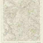
Aberystwyth, Sheet 16 - Bartholomew's "Half Inch to the Mile Maps" of England & Wales

Titolo completo:Aberystwyth, Sheet 16 - Bartholomew's "Half Inch to the Mile Maps" of England & Wales
Anno di illustrazione:1905
Data di pubblicazione:1905
Editore:John Bartholomew & Co
Dimensione fisica:20 x 30 cm
Scala della mappa:1:126 720
An accurate map of Radnor Shire
1754
Kitchin; Tinney
Radnoria comitatvs
1646
Blaeu
An accurate map of Brecknock Shire
1754
Kitchin; Tinney
Comitatvs Brechiniæ
1646
Blaeu
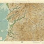
Montgomery and Llandrindod Wells - OS One-Inch Map
1948
Ordnance Survey
1:63k
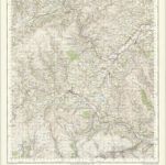
Brecon - OS One-Inch Map
1959
Ordnance Survey
1:63k
Aberystwyth, Sheet 16 - Bartholomew's "Half Inch to the Mile Maps" of England & Wales
1905
Bartholomew, John George
1:127k
A New and accurate map of Radnor Shire
1766
1:238k
Montgomeria comitatus et comitatus Mervinia
1646
Blaeu
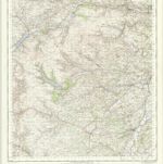
Bala and Welshpool - OS One-Inch Map
1949
Ordnance Survey
1:63k