Maps of Carpathian Mountains
Hungaria. [Karte], in: Gerardi Mercatoris Atlas, sive, Cosmographicae meditationes de fabrica mundi et fabricati figura, S. 412.
1 Karte aus Atlas Mercator, Gerhard Montanus, Petrus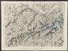
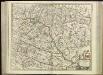
Hungaria Regnum. [Karte], in: Theatrum orbis terrarum, sive, Atlas novus, Bd. 1, S. 105.
1 Karte aus Atlas Blaeu, Joan Blaeu, Willem Janszoon
HVNGARIA | REGNVM
Amsterdami | Apud Guiljelmum et Johannem Blaeu
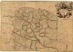
Hungaria Regnum. [Karte], in: Le théâtre du monde, ou, Nouvel atlas contenant les chartes et descriptions de tous les païs de la terre, Bd. 1, S. 227.
1 Karte aus Atlas Blaeu, Willem Janszoon und Blaeu, Joan Blaeu, Willem Janszoon
Le Royaume d'Hongrie - Hungaria
Ungarn, Slowakei Briet, Philippe
Hungariae Regnum. [Karte], in: Novus atlas absolutissimus, Bd. 2, S. 285.
1 Karte aus Atlas Janssonius Offizin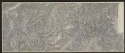
Hungaria Regnum. [Karte], in: Gerardi Mercatoris et I. Hondii Newer Atlas, oder, Grosses Weltbuch, Bd. 1, S. 346.
1 Karte aus Atlas Mercator, Gerhard und Hondius, Jodocus Jansson, Jan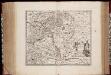
Novissima et accuratissima totius Hungariae tabula / par P. Du Val, geographe du Roij
1 : 1350000 Annotatie: Titel in het Latijn, auteursvermelding in het Frans, impressum en schaalaanduiding in het Nederlands; Origineel is Blad 131 in atlas factice; Annotatie geografische gegevens: Schaalvermelding boven schaalstok: Gemeene Duijtsche Mijlen van 15 in een graedt Pierre Du Val 1618-1683 't Amsterdam : gedruckt by Justus Danckers
Regnum Hungariae
1 : 2200000 Mollova mapová sbírka Bruggen, Johann van der Brugge, Johannes van der
Regnum Hungariae
1 : 2200000 Mollova mapová sbírka Pfeffel, Johann Andreas Pfeffel, Johann Andreas
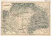
Hungaria in Partes II et Comitatus LII divisa
1 : 4300000 Mollova mapová sbírka Tomka Szászky, János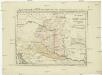
Postkarte von Nieder Ungarn, Kroatien und Sklavonien
Chorvatsko Kühn, Ignaz im von Reillyschen Landkarten und Kunstwerke Verschleiss Komptoir
Hungaria Regnum
[80][80] Regnum Hungaria ..., uit: Atlas sive Descriptio terrarum orbis
Annotatie: Gedigitaliseerde versie. Amsterdam. Heiloo : Picturae (vervaardiger), 2015. tiff-bestand. Gedigitaliseerd: 07-01-2015; Origineel: Universiteitsbibliotheek Vrije Universiteit (XL.05127.-) ; Netherlands; Titelpagina ontbreekt Wit, Frederik de Amsterdam : Frederick de Wit
Regnum Hungaria in Omnes suos Comitatus

Carte Particuliere De La Hongrie De La Transilvanie De La Croatie Et De La Sclavonie
1 : 1400000 Mollova mapová sbírka Delisle, Guillaume Schenk, Peter II
Carte Particuliere De La Hongrie De La Transilvanie De La Croatie Et De La Sclavonie
1 : 1400000 Mollova mapová sbírka Delisle, Guillaume L'Isle, Guillaume de

Hungary
1 : 860000 Mollova mapová sbírka Senex, John Senex, John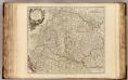
Hongrie, Transilvanie, Sclavonie, Croatie, Valaquie, Bosnie, Bulgarie.
1 : 1450000 Robert de Vaugondy, Gilles, 1688-1766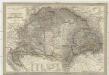
Magyar-ország
1 : 1400000 Chorvatsko Fried, Franz List, Joseph bei Artaria &. Comp.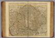
Hongrie, Transilvanie, Croatie, Sclavonie.
1 : 1390000 L'Isle, Guillaume de, 1675-1726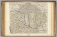
Hongrie, Transilvanie, Croatie, Sclavonie.
1 : 1390000 L'Isle, Guillaume de, 1675-1726
Magyarország és a' Hozzá kapcsolt tartományok Földabrosza
1 : 970000 Chorvatsko Raffelsperger, Franz Raffelsperger F.
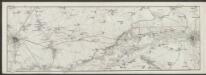
Uibersichts Karte des Kriegsschauplatzes von Ungarn und Siebenbürgen
1 : 1470000 Maďarsko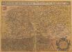
Hungariae Descriptio [Karte], in: Theatrum orbis terrarum, S. 99.
1 Karte aus Atlas Ortelius, Abraham
Ungarn und seine Nachbarländer 1919-1938
Ungarn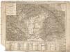
Tabula generalis regni Hungariae Croatiae et Slavoniae, nec non magni principatus Transylvaniae conspectum mappae generalis in IX. sectiones moduli majoris distributae civitates, oppida, stationes et vias postales singillatim accurateque exhibens
1 : 1396000 Chorvatsko Lipský, Ján Karacs, Ferenc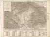
![Hungaria. [Karte], in: Gerardi Mercatoris Atlas, sive, Cosmographicae meditationes de fabrica mundi et fabricati figura, S. 412.](https://images-2.georeferencer.com/images/iiif/712001670018/full/,300/0/native.jpg)

