Maps of Carpathian Mountains

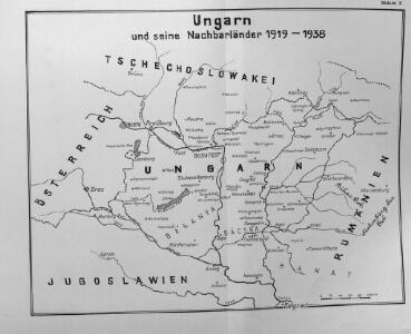
Ungarn und seine Nachbarländer 1919-1938
Ungarn
Hungary
1 : 1000000 Hongrie. S.G.A. le 20/12/19. In: Treaty Series No. 10.1920. Treaty of Peace between the Allied and Associated Powers and Hungary. June 4, 1920. War Office
Postkarte des Königreichs Ung.Übersciht von Wien über Ofen bis Kronstadt ; und von Venedig, Triest, Fiume bis Lemberg und Brody
Ungarn Kroatien Postroute Verkehrsweg
Hongrie
1 : 1000000 Maďarsko Senát Národního shromáždění
Hungary.
1 : 3800000 Darton, William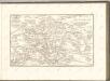
Das Königreich Ungarn nach seiner natürlichen und politischen Ansicht. Übersicht der Komitate
Ungarn Kroatien Verwaltungsbezirk Komitat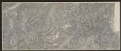
Hungaria Regnum. [Karte], in: Gerardi Mercatoris et I. Hondii Newer Atlas, oder, Grosses Weltbuch, Bd. 1, S. 346.
1 Karte aus Atlas Mercator, Gerhard und Hondius, Jodocus Jansson, Jan
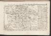
Karte der Königreiche Ungarn, Croatien, Slavonien und Militärgrenzen
Karte von Ungarn
Maďarsko Torsch, Franz
Hungariae Regnum. [Karte], in: Novus atlas absolutissimus, Bd. 2, S. 285.
1 Karte aus Atlas Janssonius Offizin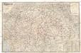
Magyarország és Horvát-Szlavonország
1 : 900000 Evropa východní Eggenberger-féle könyvkereskedés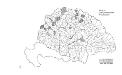
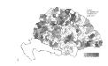
Die konservativen Wahlbezirke
Ungarn Wahlbezirk, Wahlverhalten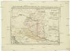
Postkarte von Nieder Ungarn, Kroatien und Sklavonien
Chorvatsko Kühn, Ignaz im von Reillyschen Landkarten und Kunstwerke Verschleiss Komptoir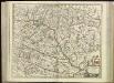
[80][80] Regnum Hungaria ..., uit: Atlas sive Descriptio terrarum orbis
Annotatie: Gedigitaliseerde versie. Amsterdam. Heiloo : Picturae (vervaardiger), 2015. tiff-bestand. Gedigitaliseerd: 07-01-2015; Origineel: Universiteitsbibliotheek Vrije Universiteit (XL.05127.-) ; Netherlands; Titelpagina ontbreekt Wit, Frederik de Amsterdam : Frederick de Wit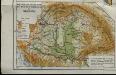
Mountains and plains of the old kingdom of Hungary [Nebenkarte]
Ungarn Topografie Teleki, Pál Teleki, Pál
Regnum Hungariae
1 : 2200000 Mollova mapová sbírka Bruggen, Johann van der Brugge, Johannes van der
Regnum Hungariae
1 : 2200000 Mollova mapová sbírka Pfeffel, Johann Andreas Pfeffel, Johann Andreas
Die kaiserl. oesterreichischen ungarischen Erbstaaten
1 : 2276000 Maďarsko Weiland, Karl Ferdinand Jungmann, Carl im Verlage des Geograph. Instituts
Magyarország és a' Hozzá kapcsolt tartományok Földabrosza
1 : 970000 Chorvatsko Raffelsperger, Franz Raffelsperger F.
Tabula generalis regni Hungariae, Croatiae et Slavoniae nec non magni principatus Tranylvaniae
1 : 1400000 Chorvatsko Lipský, Ján Marcum Berra
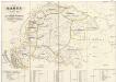
Magyarország hegy- és vizrajzi térképe
1 : 3500000 Karpaty (pohoří : oblast) Homolka, Josef Posner Károly Lajos és Fia
Hungary.
1 : 3041280 Tallis, J. & F.
Strassen-Karte des Koenigreiches Ungarn
1 : 430000 Uhersko A. Floder
Regnum Hungaria in Omnes suos Comitatus
Karte von Königreich Ungarn und den zugehörigen Nebenländern
1 : 1887000 Maďarsko Schmitfeldt, Georg Lipský, Ján Florian Mollo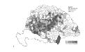
Die Bezirke der Tendenz "C" nach 1875
Ungarn Wahlbezirk, Wahlverhalten