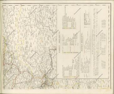
Maps of Carpathian Mountains


Hungaria Regnum

HVNGARIA | REGNVM
Amsterdami | Apud Guiljelmum et Johannem Blaeu
Hungaria. [Karte], in: Gerardi Mercatoris Atlas, sive, Cosmographicae meditationes de fabrica mundi et fabricati figura, S. 412.
1 Karte aus Atlas Mercator, Gerhard Montanus, Petrus
Hongrie.
1 : 4500000 Delamarche, Charles Francois; Lattre, Jean
Hungary
1 : 860000 Mollova mapová sbírka Senex, John Senex, John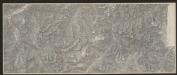
Hungaria Regnum. [Karte], in: Gerardi Mercatoris et I. Hondii Newer Atlas, oder, Grosses Weltbuch, Bd. 1, S. 346.
1 Karte aus Atlas Mercator, Gerhard und Hondius, Jodocus Jansson, Jan
Postkarte von Nieder Ungarn, Kroatien und Sklavonien
Chorvatsko Kühn, Ignaz im von Reillyschen Landkarten und Kunstwerke Verschleiss Komptoir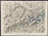
Hungaria Regnum. [Karte], in: Theatrum orbis terrarum, sive, Atlas novus, Bd. 1, S. 105.
1 Karte aus Atlas Blaeu, Joan Blaeu, Willem Janszoon
Uhry a Sedmihradsko
1 : 3700000 Maďarsko nákladem u Marka Berri
Hungaria Regnum. [Karte], in: Le théâtre du monde, ou, Nouvel atlas contenant les chartes et descriptions de tous les païs de la terre, Bd. 1, S. 227.
1 Karte aus Atlas Blaeu, Willem Janszoon und Blaeu, Joan Blaeu, Willem Janszoon
Novissima et accuratissima totius Hungariae tabula / par P. Du Val, geographe du Roij
1 : 1350000 Annotatie: Titel in het Latijn, auteursvermelding in het Frans, impressum en schaalaanduiding in het Nederlands; Origineel is Blad 131 in atlas factice; Annotatie geografische gegevens: Schaalvermelding boven schaalstok: Gemeene Duijtsche Mijlen van 15 in een graedt Pierre Du Val 1618-1683 't Amsterdam : gedruckt by Justus Danckers
Karte der Königreiche Ungarn und Galizien
1 : 2000000 Halič (Polsko a Ukrajina) Artaria & Comp.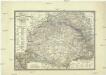
Karte der Königreiche Ungarn und Galizien
1 : 2000000 Sedmihradsko (Rumunsko) Artaria & comp.
Karte der Königreiche Ungarn und Galizien
1 : 2000000 Halič (Polsko a Ukrajina) Artaria & Comp.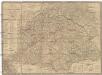
Karte von Ungarn und Galizien
1 : 2000000 Halič (Polsko a Ukrajina) Fried, Franz Artaria & Comp.
Ungarn Galizien und Siebenbürgen
1 : 2551000 Halič (Polsko a Ukrajina) Theinert, A.
Ungern, Siebenbürgen und Galizien
1 : 2551000 Halič (Polsko a Ukrajina) Theinert, A. Flemming, C. C. Flemming
Le Royaume d'Hongrie - Hungaria
Ungarn, Slowakei Briet, Philippe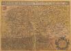
Hungariae Descriptio [Karte], in: Theatrum orbis terrarum, S. 99.
1 Karte aus Atlas Ortelius, Abraham
Hungaria Regnum. [Karte], in: Novus Atlas, das ist, Weltbeschreibung, Bd. 1, S. 196.
1 Karte aus Atlas Blaeu, Joan Blaeu, Willem Janszoon

Hungariae Regnum. [Karte], in: Novus atlas absolutissimus, Bd. 2, S. 285.
1 Karte aus Atlas Janssonius Offizin
Serenissimo ac Potentissimo Hungariae Regi Josepho Primo
1 : 680000 Mollova mapová sbírka Colloredo, Fabius Antonius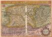
Hungariae Descriptio [Karte], in: Theatrum orbis terrarum, S. 265.
1 Karte aus Atlas Ortelius, Abraham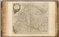
Hongrie, Transilvanie, Sclavonie, Croatie, Valaquie, Bosnie, Bulgarie.
1 : 1450000 Robert de Vaugondy, Gilles, 1688-1766
Hungaria in Partes II et Comitatus LII divisa
1 : 4300000 Mollova mapová sbírka Tomka Szászky, János
[Ungarn, Siebenbürgen, Woivodina und Slavonien]
Hand-Atlas über alle Theile der Erde und über das Weltgebäude Stieler, Adolf Justus Perthes
Regnum Hungariae
1 : 2200000 Mollova mapová sbírka Bruggen, Johann van der Brugge, Johannes van der