Maps of Saxony
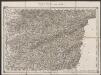
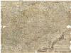
Saxoniae superioris Lusatiae Misniaeque descriptio [Karte], in: Gerardi Mercatoris Atlas, sive, Cosmographicae meditationes de fabrica mundi et fabricati figura, S. 391.
1 Karte aus Atlas Mercator, Gerhard Montanus, Petrus
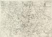
Saxonia Superior, Cum Lusatia Et Misnia. [Karte], in: Le théâtre du monde, ou, Nouvel atlas contenant les chartes et descriptions de tous les païs de la terre, Bd. 1, S. 196.
1 Karte aus Atlas Blaeu, Willem Janszoon und Blaeu, Joan Blaeu, Willem Janszoon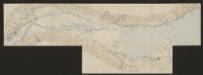
Saxoniae superioris Lusatiae Misniaeque descriptio [Karte], in: Gerardi Mercatoris et I. Hondii Newer Atlas, oder, Grosses Weltbuch, Bd. 1, S. 313.
1 Karte aus Atlas Mercator, Gerhard und Hondius, Jodocus Jansson, Jan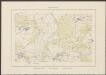
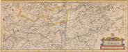
Saxonia Superior, Cum Lusatia Et Misnia. [Karte], in: Theatrum orbis terrarum, sive, Atlas novus, Bd. 1, S. 153.
1 Karte aus Atlas Blaeu, Joan Blaeu, Willem Janszoon
Saxonia Superior, Cum Lusatia Et Misnia. [Karte], in: Novus Atlas, das ist, Weltbeschreibung, Bd. 1, S. 165.
1 Karte aus Atlas Blaeu, Joan Blaeu, Willem Janszoon
SAXONIA SVPERIOR, CVM LVSATIA ET MISNIA.
[Amsterdam : Joan Blaeu]
Feldzug von 1756
[Preuß. Generalstab]
Operations-Karte, zum Feldzuge in Sachsen und Schlesien gehoerig
Neue und accurate Landkarte des Mittägig- Ober- Sächsischen R. Reichs- Creyß
1 : 700000 Bavorsko (Německo) Lidl, Johann Jakob Johann Jacob Lidl
Carte Itineraire par le Pays de l'Electorat de Saxe
1 : 800000 Mollova mapová sbírka Homann, Johann Baptist Homann, Johann Baptista - dědici
A new and accurate map of Saxony, part of Brandenburg, Silesia, Poland and Bohemia
1 : 1235000 Braniborsko (Německo) Hinton, J. J. Hinton
Operationen des Corps des Prinzen Heinrich, der Oestreichschen Haupt-Armee, und der Reichs-Truppen vom 13ten August bis 3ten November 1759
Saxonia Svperiore
1 : 800000 Mollova mapová sbírka Cosmerovius, Matthäus Cosmerovius, Matthäus
Karte über die Circulation der böhmischer Braunkohle während des Jähres 1869
Evropa střední Pechar, Johann C.H. Hunger
Saxoniae superioris Lvsatiae Misniaeqve descriptio
1 : 785000 Lužice (Německo) Mercator, Gerhard
Ietziges Kriegs Theatrum in Sachsen, Böhmen, u. Schlesien
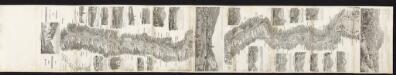
Albis. Fluvius Germaniae celebris A Fontibus Ad Ostia, Cum fluminibus ab utroque latere in illum fluentibus, descriptus. [Karte, Teil 2], in: Novus atlas absolutissimus, Bd. 2, S. 30.
1 Karte aus Atlas Janssonius Offizin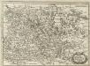
Ober Sachsen, Laussnitz und Meissen
1 : 1200000 Mollova mapová sbírka Merian, Matthaeus Merian, Matthäus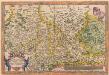
Saxoniae, Misniae, Thuringiae, Nova Exactissimaque Descriptio. [Karte], in: Theatrum orbis terrarum, S. 127.
1 Karte aus Atlas Ortelius, Abraham
Saxonia Svperior, Cvm Lvsatia et Misnia
1 : 780000 Mollova mapová sbírka Blaeu, Joan Blaeu, Joan I.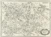
Ober Sachsen Laußnitz vnd Meissen
1 : 1200000 Mollova mapová sbírka Merian, Matthaeus Merian, Matthäus
Circulus Saxoniae Superioris
1 : 480000 Mollova mapová sbírka Valk, Gerhard Valck, Gerard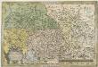
Saxoniae Misniae, Thvringiae, Nova Exactissimaque Descriptio
1 : 900000 Mollova mapová sbírka Ortelius, Abraham Plantin, Christoph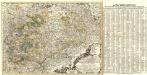
Neue und accurate Landkarte des Mittägig- Ober- Sächsischen K. Reichs- Creyß
1 : 675000 Mollova mapová sbírka Lidl, Johann Jakob Lidl, Johann Jacob

Geologická mapa Československé republiky

Tabella conventuum alma reformata provincia Bohemia S. Wenceslai D. et M. inquibus sub r.mo pre Ioanne a Soto totius ord. S.P. Francisci, ministro generali, et r.mo pre Iosepho Maria ab Ebora Cismont. familia comissario grli, ac A.R.P. ; Severino Wrbczanskij mnro proali. religio seraphica pro Deo, et proxima voex voto laborat
1 : 4000000 Česko Mansfelt, A.
Misniae Et Lusatiae Tabula [Karte], in: Theatrum orbis terrarum, S. 230.
1 Karte aus Atlas Ortelius, Abraham Vrients, Jan Baptista
![Saxoniae superioris Lusatiae Misniaeque descriptio [Karte], in: Gerardi Mercatoris Atlas, sive, Cosmographicae meditationes de fabrica mundi et fabricati figura, S. 391.](https://images-2.georeferencer.com/images/iiif/621525870579/full/,300/0/native.jpg)

