Maps of Saxony


Saxoniae superioris Lusatiae Misniaeque descriptio [Karte], in: Gerardi Mercatoris Atlas, sive, Cosmographicae meditationes de fabrica mundi et fabricati figura, S. 391.
1 Karte aus Atlas Mercator, Gerhard Montanus, Petrus
Saxonia Svperiore
1 : 800000 Mollova mapová sbírka Cosmerovius, Matthäus Cosmerovius, Matthäus
Circulus Saxoniae Superioris
1 : 480000 Mollova mapová sbírka Valk, Gerhard Valck, Gerard
Saxoniae superioris Lvsatiae Misniaeqve descriptio
1 : 785000 Lužice (Německo) Mercator, Gerhard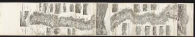
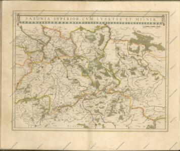
Saxonia Superior, Cum Lusatia Et Misnia. [Karte], in: Le théâtre du monde, ou, Nouvel atlas contenant les chartes et descriptions de tous les païs de la terre, Bd. 1, S. 196.
1 Karte aus Atlas Blaeu, Willem Janszoon und Blaeu, Joan Blaeu, Willem Janszoon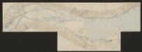
Saxoniae superioris Lusatiae Misniaeque descriptio [Karte], in: Gerardi Mercatoris et I. Hondii Newer Atlas, oder, Grosses Weltbuch, Bd. 1, S. 313.
1 Karte aus Atlas Mercator, Gerhard und Hondius, Jodocus Jansson, Jan
Saxonia Superior, Cum Lusatia Et Misnia. [Karte], in: Theatrum orbis terrarum, sive, Atlas novus, Bd. 1, S. 153.
1 Karte aus Atlas Blaeu, Joan Blaeu, Willem Janszoon
Saxonia Superior, Cum Lusatia Et Misnia. [Karte], in: Novus Atlas, das ist, Weltbeschreibung, Bd. 1, S. 165.
1 Karte aus Atlas Blaeu, Joan Blaeu, Willem Janszoon
SAXONIA SVPERIOR, CVM LVSATIA ET MISNIA.
[Amsterdam : Joan Blaeu]
Carte Itineraire par le Pays de l'Electorat de Saxe
1 : 800000 Mollova mapová sbírka Homann, Johann Baptist Homann, Johann Baptista - dědici
Operationum bellicarum in Germania ulterior Repraesentatio
1 : 700000 Mollova mapová sbírka Rizzi Zannoni, Giovanni Antonio Homann, Johann Baptista - dědici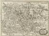
Ober Sachsen, Laussnitz und Meissen
1 : 1200000 Mollova mapová sbírka Merian, Matthaeus Merian, Matthäus
A new and accurate map of Saxony, part of Brandenburg, Silesia, Poland and Bohemia
1 : 1235000 Braniborsko (Německo) Hinton, J. J. Hinton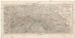
Schlesien, Königreich Sachsen und nördliches Böhmen
1 : 740000 Sasko (Německo) Justus Perthes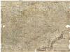
Neue und accurate Landkarte des Mittägig- Ober- Sächsischen R. Reichs- Creyß
1 : 700000 Bavorsko (Německo) Lidl, Johann Jakob Johann Jacob Lidl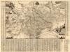
Neue Chur Saechsische Post Carte
1 : 330000 Mollova mapová sbírka Zürner, Adam Friedrich Bodenehr, Moritz
Misniae et Lvsatiae tabvla
1 Karte : Kupferdruck ; 28 x 20 cm Scultetus; Ortelius s.n.
Misniae et Lvsatiae tabvla
1 Karte : Kupferdruck ; 28 x 20 cm Scultetus; Ortelius s.n.
Norddeutsche Staaten

Haupt-Kriegs-Plan in Sachsen und den angränzenden Ländern
Sasko (Německo) Verlage des Thadé Weigl am Graben
Saxoniae, Misniae, Thvringiae, nova exactissimaq[ue] descriptio
1 Karte : Kupferdruck ; 31 x 47 cm Ortelius s.n.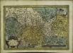
Saxoniae, Misniae, Thvringiae, nova exactissimaq[ue] descriptio
1 Karte : Kupferdruck ; 32 x 48 cm Ortelius s.n.
Marchionatus Misniae in qua sunt Territorium Misniense, Lipsiense, Voitlandiae, Osterlandiae, Ertzgeburgi et Dominium Naumburgense Mersoburgense. Episcopatus Hallensis
1 : 380000 Mollova mapová sbírka Danckerts, Justus Danckerts, Justus
Misniae Et Lusatiae Tabula [Karte], in: Theatrum orbis terrarum, S. 138.
1 Karte aus Atlas Ortelius, Abraham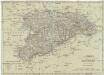
Königreich Sachsen
1 : 632000 Sasko (Německo) Mollo, Tranquillo T. Mollo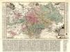
Aller Neueste Chur Saechsische Post Charte
1 : 340000 Mollova mapová sbírka Zürner, Adam Friedrich Lotter, Tobias Conrad
Carte de la Haute Saxe et de la Lusace
1 : 900000 Lužice (Německo) Mentelle, Edme Tardieu, Pierre François