Maps of Switzerland

Neue Karte von der Schweiz in XIII Cantone eingetheilt, nebst ihren Bundsverwandten und Unterthanen
1 : 750000 1 Karte se vend vis-à-vis de la poste chez S. Schropp et Comp., Berlin
Randegger's Reisekarte der Schweiz
1 : 600000 1 Karte [Kartogr.:] Topogr. Anstalt v. Wurster, Randegger & Co. in Winterthur J. Wurster & Co., Zürich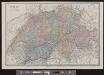
Suisse
1 : 487000 1 Karte E. Andriveau-Goujon ; gravé: le trait par Smith, la topographie par Gérin, les écritures par P. Rousset, les eaux par Mme Fontaine Andriveau-Goujon, Paris
Helvetia
1 : 1700000 1 Karte [excusum in aedibus Iudoci Hondij], [Amsterodami]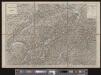
Randegger's Reisekarte der Schweiz
1 : 600000 1 Karte [Kartogr.:] Topogr. Anstalt v. Wurster, Randegger & Co. in Winterthur J. Wurster & Co., Zürich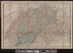
Suisse
1 : 487000 1 Karte E. Andriveau-Goujon ; gravé: le trait par Smith, la topographie par Gérin, les écritures par P. Rousset, les eaux par Mme Fontaine Andriveau-Goujon, Paris
[Recto], uit: Suisse : carte du touriste / Orell Füssli
1 : 750000 Orell Füssli, Zürich Berne : Chemins de Fer Fédéraux
General Charte von der Schweiz
1 : 577000 1 Karte auf 18 Blättern auf 1 Leinwand aufgezogen von C. F. Weiland Verlage des Geograph. Instituts, Weimar
Geologische Karte der Schweiz
Originaltitel: Carte géologique de la Suisse. Mit Legende der Farben. Studer, Bernhard (1794-1887), Theologe und Naturwissenschafter, von Bern; Escher von der Linth, Arnold (1807-1872), Geologe, von Zürich Zeichnung: Ziegler, Jakob Melchior (1801-1883), Kartograf Verlag: Joh. Wurster und Comp., in Winterthur
Karte der Schweiz für Schulen
1 : 800000 1 Karte von R. Leuzinger Verlag der J. Dalp'schen Buch & Kunsthandlung (Carl Schmid), Bern
Helvetia cum subditis & sociis Helvet. ad usum temporis nostri
1 : 1000000 1 Karte Christ. Weigel excudente ; Michael Kauffer sculp. Weigel, Noribergae
Geologische Übersichtskarte der Schweiz
1 : 760000 Escher von der Linth, Arnold ; Studer, Bernhard Verlag d. topogr. Anstalt v. J. Wurster u. Comp.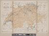
Karte der Schweiz
1 : 800000 1 Karte R. Leuzinger J. Dalp'sche Buch & Kunsthandlung (C. Schmid), Bern
Potentissimae Helvetiorum reipublicae cantones tredecim cum foederatis et subjectis provinciis
1 : 580000 1 Karte exhibiti a Joh. Baptista Homanno [Homännische Erben], Noribergae
Neue Schweizerkarte von 1847 : als Wand- und Reisekarte topisch und politisch dargestellt
Winckelmann, Eduard Tannheimer
Carte physique et routière de la Suisse
1 : 490000 1 Karte publiée par J. Andriveau-Goujon J. Andriveau-Goujon, Paris
Charte von der Schweiz nach ihrer jezigen Eintheilung
1 : 880000 1 Karte im Verlage des Geograph. Instituts, Weimar
Officielle Uebersichtskarte der Schweiz. Eisenbahnen
1 : 800000 1 Karte J. Dalp'sche Buch & Kunsthandlung (Carl Schmid), Bern
Mineral-Quellen der Schweiz und ihrer nächsten Umgebungen
1 : 1200000 Topographische Anstalt von Joh. Wurster u. Comp. (Winterthur) [Naturforschende Gesellschaft?]
Karte der schweizerischen Telegraphenlinien und Bureaux
1 : 600000 1 Karte zusammengestellt von der schweizerischen Telegraphen-Direction = Carte des lignes et bureaux des télégraphes suisses / dressée par la Direction des télégraphes suisses Wurster, Winterthur
Reise-Charte von der Schweitz
1 : 450000 1 Karte in 2 Teilen [William Coxe, Heinrich August Ottokar Reichard] ; [J. Rausch sc. Nürnb.] Institut géographique, Weimar
<<Les>> Suisses et les Grisons avec leurs alliés et leurs sujets
1 : 1000000 1 Karte par [Gilles et Didier] Robert de Vaugondy ; gravé par E. Dussy ; Arrivet inv. & sculp. [chés le S. Robert], [Paris]
<<La>> Suisse
1 : 800000 1 Karte Keller, Zürich
Carte de la Suisse avec des noms en marge
1 : 850000 1 Karte gezeichnet und herausgegeben von Heinrich Keller ; Lith. von Schweizer Heinrich Keller, untre Zäune No. 367, Zürich
Novissima et accuratissima Helvetiae, Rhaetiae, Valesiae et partis Sabaudiae tabula
1 Karte Tobias Conrad Lotter, Chalcogr. apud Tobiam Conr. Lotter, Augustae Vindelicorum
Carte de la Suisse, ou l'on a marqué les routes suivies par Wil. Coxe dans ses quatre voyages en 1776, 1779, 1785 et 1786
1 : 450000 1 Karte Picquet direx.t. [chez Letellier, quai des Augustins No. 50], [Paris]
Hypsometrische Karte der Schweiz
1 : 380000 1 Karte auf 4 Blättern von J.M. Ziegler = Carte hypsométrique de la Suisse / par J.M. Ziegler Verlag von Joh. Wurster u. Comp., Winterthur
<<La>> Suisse
1 : 800000 1 Karte Keller, Zürich
Reise-Karte durch die XXII Cantone der Schweiz
1 : 600000 1 Karte lithgr. v. A. Haas ; Terrain v. C. Wenng Jos. Lindauer'sche Buchhandlung, München


