Maps of Switzerland

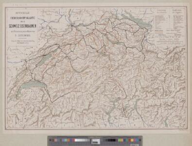
Officielle Uebersichtskarte der Schweiz. Eisenbahnen
1 : 800000 1 Karte J. Dalp'sche Buch & Kunsthandlung (Carl Schmid), Bern
Karte der Schweiz für Schulen
1 : 800000 1 Karte von R. Leuzinger Verlag der J. Dalp'schen Buch & Kunsthandlung (Carl Schmid), Bern
Karte der Schweiz
1 : 800000 1 Karte R. Leuzinger J. Dalp'sche Buch & Kunsthandlung (C. Schmid), Bern
Karte der Schweiz mit Bezeichnung der Föhngebiete
1 : 800000 1 Karte [Verlag nicht ermittelbar], [Erscheinungsort nicht ermittelbar]
<<Les>> Suisses, leurs sujets et leurs alliéz
1 Karte corrigée et augmentée d'après les nouvelles observations de Ms. de l'Académie Royale des Sciences ; P. Starckman sculpsit chez Desnos, Rue St. Jacques au Globe, Paris
Karte der Schweiz
1 : 600000 1 Karte bearb. unter Mitwirkung hervorragender Schulmänner von J. Randegger Topogr. Anst. v. Wurster, Randegger u. Co., Winterthur
Reise-Charte von der Schweitz
1 : 450000 1 Karte in 2 Teilen [William Coxe, Heinrich August Ottokar Reichard] ; [J. Rausch sc. Nürnb.] Institut géographique, Weimar
Charte von der Schweiz nach ihrer jezigen Eintheilung
1 : 880000 1 Karte im Verlage des Geograph. Instituts, Weimar
Petite carte de la Suisse pour les écoles
1 : 800000 1 Karte gezeichnet und herausgegeben von Heinrich Keller Keller, [Zürich]
Karte der Schweiz
1 : 600000 1 Karte bearb. unter Mitwirkung hervorragender Schulmänner von J. Randegger Topogr. Anst. v. Wurster, Randegger u. Co., Winterthur
Helvetia
1 : 1700000 1 Karte [excusum in aedibus Iudoci Hondij], [Amsterodami]
Karte der Schweiz
1 : 600000 1 Karte bearb. unter Mitwirkung hervorragender Schulmänner von J. Randegger Topogr. Anstalt Winterthur J. Schlumpf, vorm. Wurster, Randegger u. Co., Winterthur
Helvetia cum finitimis regionibus confoederatis
1 : 800000 1 Karte per Gerardum Mercatorem [Mercator], [Duisburg]
[Schweiz]
1 : 520000 1 Karte [Keller?], [Zürich?]
Reise-Karte durch die XXII Cantone der Schweiz
1 : 600000 1 Karte lithgr. v. A. Haas ; Terrain v. C. Wenng Jos. Lindauer'sche Buchhandlung, München
[Schweiz]
1 : 760000 1 Karte [Verlag nicht ermittelbar], [Erscheinungsort nicht ermittelbar]
Potentissimae Helvetiorum reipublicae cantones tredecim cum foederatis et subjectis provinciis
1 : 580000 1 Karte exhibiti a Joh. Baptista Homanno [Homännische Erben], Noribergae
Keller's lithographirte Reisekarte der Schweiz
1 : 500000 1 Karte gez. v. H. Keller ; G. Frauenfelder lith. [Keller], [Zürich]
Carte de la Suisse
1 : 600000 1 Karte dressée avec le concours de professeurs éminents par J. Randegger Wurster, Winterthur
Karte der Schweiz
1 : 800000 1 Karte R. Leuzinger J. Dalp'sche Buch & Kunsthandlung (C. Schmid), Bern
Oro-hydrographische Karte der Schweiz
1 : 600000 1 Karte bearb. von J. Randegger Wurster, Randegger & Cel. Winterthur, Winterthur
Novissima et accuratissima Helvetiae, Rhaetiae, Valesiae et partis Sabaudiae tabula
1 : 550000 1 Karte [Jeremias Wolf] ex officina Ierem. Wolfii, Aug. Vind.
Karte der Fundorte von Rohproducten in der Schweiz
1 : 520000 1 Karte von Julius Weber und A. Brosi ; veröffentlicht auf Veranlassung des Schweizerischen Handels u. Landwirthschafts-Departements ; [Kartogr.:] Topogr. Anstalt v. Wurster, Randegger & Co. J. Wurster & Cie., Zürich
Helvetia foederata cum ea region
1 : 1400000 1 Karte Georg Christoph Kilian excudit ; T. Majer del. Georg Christoph Kilian, Aug. Vind.
Oro-hydrographische Karte der Schweiz
1 : 600000 1 Karte Wurster, Randegger & Co., Winterthur
Karte der Schweiz
1 : 800000 1 Karte R. Leuzinger J. Dalp'sche Buch & Kunsthandlung (C. Schmid), Bern
Carte routière de la Suisse
1 : 570000 1 Karte par [Henri] Keller ; gravée par Pierre Tardieu ; écrit par J.D. Lale [Hipte. Souverain?], Paris
Novissima et accuratissima Helvetiae, Rhaetiae, Valesiae et partis Sabaudiae tabula
1 : 550000 1 Karte R. & J. Ottens ex officina R. & I. Ottens, Amst.
Helvetia cum subditis & sociis Helvet. ad usum temporis nostri
1 : 1000000 1 Karte Christ. Weigel excudente ; Michael Kauffer sculp. Weigel, Noribergae