Maps of Switzerland

Novissima et accuratissima Helvetiae, Rhaetiae, Valesiae et partis Sabaudiae tabula
1 : 550000 1 Karte [Jeremias Wolf] ex officina Ierem. Wolfii, Aug. Vind.
[Schweiz]
1 : 520000 1 Karte [Keller?], [Zürich?]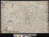
Helvetiae, Rhaetiae et Valesiae caeterorumque confoederatorum ut & finitimorum populorum tabula geographica et hydrographica nova & exacta
1 : 470000 1 Karte operâ & studio Ioh. Conradi Gygeri delineata & à Conrado Meyero in aes incisa, anno Christi 1657 [Verlag nicht ermittelbar], [Zürich]
Novissima et accuratissima Helvetiae, Rhaetiae, Valesiae et partis Sabaudiae tabula
1 : 550000 1 Karte R. & J. Ottens ex officina R. & I. Ottens, Amst.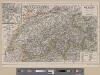
<<Die>> Schweiz
1 : 1200000 1 Karte Kartogr. lith. Anst. v. G. Freytag & Berndt A. Hartleben's Verlag, [Erscheinungsort nicht ermittelbar]
Novissima et accuratissima Helvetiae, Rhaetiae, Valesiae et partis Sabaudiae tabula
1 : 550000 1 Karte [Justus Danckerts der Ältere] ex officina Iusti Danckerts, Amst.
Novissima et accuratissima Helvetiae, Rhaetiae, Valesiae et partis Sabaudiae tabula
1 Karte Tobias Conrad Lotter, Chalcogr. apud Tobiam Conr. Lotter, Augustae Vindelicorum
Carte des lignes et bureaux des télégraphes suisses
1 : 600000 1 Karte dressée par la Direction des Télégraphes Suisses = Karte der schweizerischen Telegraphenlinien u. Bureaux / zusammengestellt von der Schweizerischen Telegraphen Direction Wurster, Winterthur
Potentissimae Helvetiorum reipublicae cantones tredecim cum foederatis et subjectis provinciis
1 : 580000 1 Karte exhibiti a Joh. Baptista Homanno Homann, Noribergae
Novissima et accuratissima Helvetiae, Rhaetiae, Valesiae et partis Sabaudiae tabula
1 : 550000 1 Karte [Justus Danckerts der Ältere] ex officina Iusti Danckerts, Amst.
Karte der Fundorte von Rohproducten in der Schweiz
1 : 520000 1 Karte von Julius Weber und A. Brosi ; veröffentlicht auf Veranlassung des Schweizerischen Handels u. Landwirthschafts-Departements ; [Kartogr.:] Topogr. Anstalt v. Wurster, Randegger & Co. J. Wurster & Cie., Zürich
[Schweiz]
1 : 1100000 1 Karte [Homann], [Nürnberg]
Carte générale de l'Atlas Suisse
1 : 500000 1 Karte au depens de J.R. Meyer ; levé et dessiné par J.H. Weiss ; gravé par Guérin et Scheurmann Meyer, Aarau
Helvetia cum subditis & sociis Helvet. ad usum temporis nostri
1 : 1000000 1 Karte Christ. Weigel excudente ; Michael Kauffer sculpsit Weigel, Noribergae
Potentissimae Helvetiorum reipublicae cantones tredecim cum foederatis et subjectis provinciis
1 : 580000 1 Karte exhibiti a Joh. Baptista Homanno [Homännische Erben], Noribergae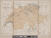
Karte der Schweiz
1 : 800000 1 Karte R. Leuzinger J. Dalp'sche Buch & Kunsthandlung (C. Schmid), Bern
<<Les>> Suisses, leurs sujets et leurs alliéz
1 Karte corrigée et augmentée d'après les nouvelles observations de Ms. de l'Académie Royale des Sciences ; P. Starckman sculpsit chez Desnos, Rue St. Jacques au Globe, Paris
Helvetia cum subditis & sociis Helvet. ad usum temporis nostri
1 : 1000000 1 Karte Christ. Weigel excudente ; Michael Kauffer sculp. Weigel, Noribergae
Uebersichtskarte aller am "Arbeiter-Secretariat" interessirten Vereine
1 : 500000 1 Karte gezeichnet und zu beziehen von G.M. Bay R. Müller-Tobler, Zürich
Karte der Schweiz
1 : 800000 1 Karte R. Leuzinger J. Dalp'sche Buch & Kunsthandlung (Carl Schmid), Bern
[Carte de la Suisse à l'usage des écoles Suisses]
1 : 850000 1 Karte [dessinée et publiée par H. Keller] = Charte der Schweiz für Schweizer Schulen [H. Keller], [Zürich]
Charte von Helvetien unter den Römern
1 : 845000 1 Karte gestochen von J.J. Scheurmann ; hrsg. von F.L. von Haller bey der Typograph. Buchhandlung, Bern
Officielle Uebersichtskarte der Schweiz. Eisenbahnen vom Monat Januar 1878
1 : 700000 1 Karte R. Leuzinger Schweiz. Eisenbahn- & Handelsdepartement, [Bern]
General-Charte der Schweiz in XXII Cantone abgetheilt
1 : 1200000 1 Karte gez. u. gest. v. J. Scheurman Orell, Füssli und Compagnie, Zürich
<<Die>> Viehzucht und Milchwirthschaft [i.e. Milchwirtschaft] der Schweiz
1 : 600000 6 Karten dargestellt auf Grundlage [von] Randegger's Karte der Schweiz von F. Anderegg u. W. Mengold ; Topogr. Anstalt von Wurster, Randegger & Cie. Winterthur [Verlag nicht ermittelbar], Chur
Officielle Uebersichtskarte der Schweiz. Eisenbahnen
1 : 800000 1 Karte Schweiz. Eisenbahn- & Handelsdepartement Rieder & Simmen, Bern
Relief-Reisekarte der Schweiz
1 : 530000 1 Karte gez. u. gest. von R. Leuzinger ; Schrift C. v. Hoven Verlag von Schmid, Francke & Co., Bern
Karte der Schweiz für Schulen
1 : 800000 1 Karte von R. Leuzinger Verlag von Schmid, Francke, Bern
<<Die>> Viehzucht und Milchwirthschaft [i.e. Milchwirtschaft] der Schweiz
1 : 600000 6 Karten dargestellt auf Grundlage [von] Randegger's Karte der Schweiz von F. Anderegg u. W. Mengold ; Topogr. Anstalt von Wurster, Randegger & Cie. Winterthur [Verlag nicht ermittelbar], Chur


