Maps of Switzerland

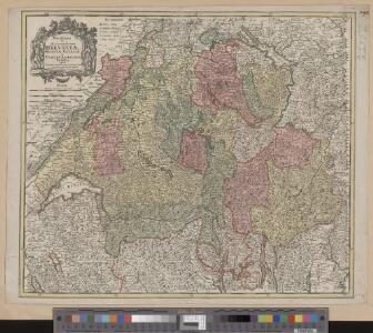
Novissima et accuratissima Helvetiae, Rhaetiae, Valesiae et partis Sabaudiae tabula
1 Karte Tobias Conrad Lotter, Chalcogr. apud Tobiam Conr. Lotter, Augustae Vindelicorum
Novissima et accuratissima Helvetiae, Rhaetiae, Valesiae et partis Sabaudiae tabula
1 : 550000 1 Karte [Jeremias Wolf] ex officina Ierem. Wolfii, Aug. Vind.
Helvetia cum subditis & sociis Helvet. ad usum temporis nostri
1 : 1000000 1 Karte Christ. Weigel excudente ; Michael Kauffer sculp. Weigel, Noribergae
Novissima et accuratissima Helvetiae, Rhaetiae, Valesiae et partis Sabaudiae tabula
1 : 550000 1 Karte R. & J. Ottens ex officina R. & I. Ottens, Amst.
Potentissimae Helvetiorum reipublicae cantones tredecim cum foederatis et subjectis provinciis
1 : 580000 1 Karte exhibiti a Joh. Baptista Homanno [Homännische Erben], Noribergae
Novissima et accuratissima Helvetiae, Rhaetiae, Valesiae et partis Sabaudiae tabula
1 : 550000 1 Karte [Justus Danckerts der Ältere] ex officina Iusti Danckerts, Amst.
[Schweiz]
1 : 520000 1 Karte [Keller?], [Zürich?]
Carte de la Suisse avec des noms en marge
1 : 860000 1 Karte gezeichnet und herausgegeben von Heinrich Keller Heinrich Keller, untere Zäune No. 367, Zürich
Novissima et accuratissima Helvetiae, Rhaetiae, Valesiae et partis Sabaudiae tabula
1 : 550000 1 Karte [Justus Danckerts der Ältere] ex officina Iusti Danckerts, Amst.
<<Die>> Schweiz
1 : 1200000 1 Karte Kartogr. lith. Anst. v. G. Freytag & Berndt A. Hartleben's Verlag, [Erscheinungsort nicht ermittelbar]
Helvetiae, Rhaetiae et Valesiae caeterorumque confoederatorum ut & finitimorum populorum tabula geographica et hydrographica nova & exacta
1 : 470000 1 Karte operâ & studio Ioh. Conradi Gygeri delineata & à Conrado Meyero in aes incisa, anno Christi 1657 [Verlag nicht ermittelbar], [Zürich]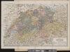
Carte de la Suisse
1 : 700000 1 Karte par W. Rosier ; Fernique, Ph. sc. Delachaux & Niestlé, Neuchâtel
<<La>> Suisse divisée en ses XIII cantons et ses alliés
1 Karte projettés et assujetié aux observat.ons astronomiques par Bonne chés Lattré, Rue S. Jacques à la ville de Bordeaux, Paris
Karte der Fundorte von Rohproducten in der Schweiz
1 : 520000 1 Karte von Julius Weber und A. Brosi ; veröffentlicht auf Veranlassung des Schweizerischen Handels u. Landwirthschafts-Departements ; [Kartogr.:] Topogr. Anstalt v. Wurster, Randegger & Co. J. Wurster & Cie., Zürich
<<L'>>Elvezia divisa ne suoi tredici cantoni e suoi alleati
1 : 900000 1 Karte G. Zuliani inc. ; G. Pitteri scri. presso Antonio Zatta, Venezia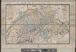
Carte de la Suisse avec des noms en marge
1 : 850000 1 Karte gezeichnet und herausgegeben von Heinrich Keller ; Lith. von Schweizer Heinrich Keller, untre Zäune No. 367, Zürich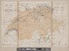
Karte der Schweiz
1 : 800000 1 Karte R. Leuzinger J. Dalp'sche Buch & Kunsthandlung (C. Schmid), Bern
Potentissimae Helvetiorum reipublicae cantones tredecim cum foederatis et subjectis provinciis
1 : 580000 1 Karte exhibiti a Joh. Baptista Homanno Homann, Noribergae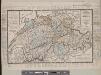
Carte de la Suisse avec des noms en marge
1 : 850000 1 Karte gezeichnet und herausgegeben von Heinrich Keller ; [Lith. von Schweizer] Heinrich Keller, untre Zäune No. 367, Zürich
Kleine officielle Eisenbahnkarte der Schweiz
1 : 500000 1 Karte gest. von R. Leuzinger ; Schweizer. Post- und Eisenbahndepartement = Petite carte officielle des chemins de fer de la Suisse Kümmerly, Bern
Helvetia
1 : 1700000 1 Karte [excusum in aedibus Iudoci Hondij], [Amsterodami]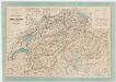
Schweizerische Eisenbahnen; offizielle Übersichtskarte
Mit Legenden in deutscher und französischer Sprache. Leuzinger, Rudolf (1826-1896), Kartograf und Lithograf, von Netstal GL und Mollis GL Herausgeber: Schweizerisches Post- und Eisenbahndepartement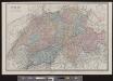
Suisse
1 : 487000 1 Karte E. Andriveau-Goujon ; gravé: le trait par Smith, la topographie par Gérin, les écritures par P. Rousset, les eaux par Mme Fontaine Andriveau-Goujon, Paris
Officielle Eisenbahnkarte der Schweiz
1 : 500000 1 Karte Schweiz. Post- & Eisenbahndepartement = Carte officielle des chemins de fer de la Suisse Kümmerly & Frey, Bern
Officielle Eisenbahnkarte der Schweiz
1 : 500000 1 Karte Schweizer. Post- und Eisenbahndepartement = Carte officielle des chemins de fer de la Suisse Kümmerly, Bern
[Recto], uit: Suisse : carte du touriste / Orell Füssli
1 : 750000 Orell Füssli, Zürich Berne : Chemins de Fer Fédéraux
[Schweiz]
1 : 1100000 1 Karte [Homann], [Nürnberg]
Carte générale des trèze cantons de Suisse, Vallay, ligues Grise, Maison-Dieu & Valteline
1 : 725000 1 Karte [par Nicolas Berey] 1654 chez N. Langlois, rue S. Jacques à la Victoire, Paris
Carte des lignes et bureaux des télégraphes suisses
1 : 600000 1 Karte dressée par la Direction des Télégraphes Suisses = Karte der schweizerischen Telegraphenlinien u. Bureaux / zusammengestellt von der Schweizerischen Telegraphen Direction Wurster, Winterthur