Maps of Switzerland

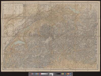
Dritte Karte der Schweiz
1 : 380000 1 Karte J.M. Ziegler Geographisches Institut von J. Meier, Zürich
Helvetia foederata cum ea region
1 : 1400000 1 Karte Georg Christoph Kilian excudit ; T. Majer del. Georg Christoph Kilian, Aug. Vind.
<<Les>> Suisses, leurs sujets et leurs alliéz
1 Karte corrigée et augmentée d'après les nouvelles observations de Ms. de l'Académie Royale des Sciences ; P. Starckman sculpsit chez Desnos, Rue St. Jacques au Globe, Paris
General Charte von der Schweiz
1 : 577000 1 Karte auf 18 Blättern auf 1 Leinwand aufgezogen von C. F. Weiland Verlage des Geograph. Instituts, Weimar
Carte topographique et routière de la Suisse et des contrées limitrophes
1 : 400000 1 Karte dressée et dessinée par Jean Frédéric d'Osterwald ; gravée à Paris par Delsol ; écrit par Hacq Chardon aîné, Paris
<<La>> Suisse
1 : 800000 1 Karte Keller, Zürich
Carte routière de la Suisse
1 : 570000 1 Karte par [Henri] Keller ; gravée par Pierre Tardieu ; écrit par J.D. Lale [Hipte. Souverain?], Paris
Charte von der Schweiz nach ihrer jezigen Eintheilung
1 : 880000 1 Karte im Verlage des Geograph. Instituts, Weimar
Karte der Schweiz
1 : 800000 1 Karte R. Leuzinger J. Dalp'sche Buch & Kunsthandlung (Carl Schmid), Bern
<<Die>> Schweiz
1 : 1200000 1 Karte Kartogr. lith. Anst. v. G. Freytag & Berndt A. Hartleben's Verlag, [Erscheinungsort nicht ermittelbar]
[Karte der Schweiz]
1 : 380000 1 Karte auf 4 Bl. J.M. Ziegler Topogr. Anstalt v. J. Wurster u. Comp., Winterthur
Dritte Karte der Schweiz
1 : 380000 1 Karte J.M. Ziegler J. Wurster & Co., Winterthur
<<La>> Suisse
1 : 800000 1 Karte Keller, Zürich
Reise-Karte durch die XXII Cantone der Schweiz
1 : 600000 1 Karte lithgr. v. A. Haas ; Terrain v. C. Wenng Jos. Lindauer'sche Buchhandlung, München
<<La>> Suisse
1 : 800000 1 Karte Keller, Zürich
<<La>> Suisse
1 : 800000 1 Karte Hch. Keller's geogr. Verlag, Zürich
Karte der Schweiz für Schulen
1 : 800000 1 Karte von R. Leuzinger Verlag der Dalp'schen Buch- & Kunsthandlung, Bern
Karte der Schweiz
1 : 600000 1 Karte bearb. unter Mitwirkung hervorragender Schulmänner von J. Randegger Topogr. Anst. v. Wurster, Randegger u. Co., Winterthur
[Karte der Schweiz]
1 : 380000 1 Karte auf 4 Bl. J.M. Ziegler Topogr. Anstalt v. J. Wurster u. Comp., Winterthur
Neue Karte der Schweiz
1 : 380000 1 Karte von J.M. Ziegler Topogr. Anstalt v. J. Wurster u. Comp., Winterthur
Petite carte de la Suisse pour les écoles
1 : 800000 1 Karte gezeichnet und herausgegeben von Heinrich Keller Keller, [Zürich]
Dritte Karte der Schweiz
1 : 380000 1 Karte von J.M. Ziegler J. Wurster & Co., Winterthur
Karte der Schweiz
1 : 800000 1 Karte R. Leuzinger J. Dalp'sche Buch & Kunsthandlung (C. Schmid), Bern
<<Die>> Schweiz
1 : 1000000 1 Karte Geograph. Anstalt Wagner & Debes Epprecht, Affoltern a.A.
Karte der Schweiz für Schulen
1 : 800000 1 Karte von R. Leuzinger Verlag von Schmid, Francke, Bern
Karte der Schweiz
1 : 800000 1 Karte R. Leuzinger J. Dalp'sche Buch & Kunsthandlung (C. Schmid), Bern
Relief-Reisekarte der Schweiz
1 : 530000 1 Karte gez. u. gest. von R. Leuzinger ; Schrift C. v. Hoven Verlag von Schmid, Francke & Co., Bern
Karte der Schweiz mit Bezeichnung der Föhngebiete
1 : 800000 1 Karte [Verlag nicht ermittelbar], [Erscheinungsort nicht ermittelbar]
Carte de la Suisse à l'usage des écoles Suisses
1 : 850000 1 Karte dessinée et publiée par H. Keller = Charte der Schweiz für Schweizer Schulen / gezeichnet und herausgegeben von H. Keller bey Heinrich Keller, Zürich