Maps of Zurich

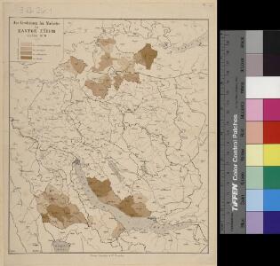
<<Das>> Erscheinen der Maikäfer im Kanton Zürich im Jahre 1876
1 : 270000 1 Karte
Canton Zürich
1 : 230000 1 Karte gezeichnet und herausgegeben von Hch. Keller ; gest. v. J. Scheurmann
<<Der>> Canton Zürich
1 : 230000 1 Karte
Canton Zürich
1 : 240000 1 Karte gezeichnet und herausgegeben von Hch. Keller
<<Der>> Canton Zürich
1 : 230000 1 Karte
Karte des Kantons Zürich
1 : 250000 1 Karte
Wegekarte vom Canton Zürich
1 : 240000 1 Karte gezeichnet und herausgegeben von Hch. Keller ; gest. v. J. Scheurmann
Karte des Kantons Zürich
1 : 250000 1 Karte
Bodenverbesserungen im Kanton Zürich
1 : 280000 1 Karte zusammengestellt von J. Girsberger
Carte des Cantons Zürich
1 : 275000 1 Karte gezeichnet und gestochen von J.H. Bachofen ; hrsg. und im Verlag von J.H. Locher
Karte des Kantons Zürich
1 : 250000 1 Karte
Canton Zürich
1 : 230000 1 Karte gezeichnet und herausgegeben von Hch. Keller ; gest. v. J. Scheurmann
<<Der>> Canton Zürich
1 : 230000 1 Karte Orell Füssli & Cp., Zürich
Canton de Zurich
1 : 291000 1 Karte dressé par Th. Duvotenay ; gravé par C. Dyonnet ; Bénard sc.
Karte des Zürichgebiets nach Murdochs Entwerfungsart
Mit Distriktseinteilung (15 Distrikte) und Erklärung der Zeichen. Orell Füssli und Cie., in Zürich Stich: Senn
Canton Zürich sive illustris Helvetiorum respublica Tigurina cum subditis suis et confinibus
1 : 135000 1 Karte recenter delineata à Gabriele Walsero
Canton Zürich
1 : 230000 1 Karte gezeichnet und herausgegeben von Hch. Keller ; gest. v. J. Scheurmann
[Geologische Karte des Kantons Zürich]
1 : 250000 1 Karte
Canton Zürich
1 : 240000 1 Karte gezeichnet und herausgegeben von Hch. Keller
<<Der>> Kanton Zürich
1 : 180000 1 Karte als Lehrmaterial der Erziehungsanstalt im Seefeld auf Stein gezeichnet von F. Beust
<<Der>> Canton Zürich
1 : 230000 1 Karte
<<Der>> Canton Zürich mit seinen nähern Angränzungen
1 : 118000 1 Karte gezeichnet und herausgegeben von Heinrich Keller ; gest. v. J. Scheurmann
Fischenthal bis Rorbas: Tössgebiet; Übersichtsplan
1 : 200000 Mit Flächenangaben zu den Gemeinden. Ohne Datumsangabe.
<<Der>> Canton Zürich
1 : 230000 1 Karte H. Keller del. ; J.J. Scheurmann sc.
<<Der>> Canton Zürich
1 : 230000 1 Karte
Karte des Kantons Zürich
1 : 125000 1 Karte J.M. Ziegler ; [gestochen von R. Leuzinger ; Schrift v. P. Steiner]
Karte des Zürichgebiets nach Murdochs Entwerfungsart
Aktualisierte Ausgabe der ersten Auflage von 1803. Mit Distriktseinteilung (5 Distrikte) und Erklärung der Zeichen. Orell Füssli und Cie., in Zürich
Karte des Kantons Zürich
1 : 125000 1 Karte J.M. Ziegler ; gestochen von R. Leuzinger ; Schrift v. P. Steiner
Atlas novus Reipublicae Helveticae
1 Atlas ([40] Bl., 97 S.) bey Orell, Gessner und Compagnie, Zürich