Maps of Zurich

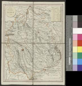
<<Der>> Canton Zürich
1 : 230000 1 Karte Orell Füssli & Cp., Zürich
Wegekarte vom Canton Zürich
1 : 240000 1 Karte gezeichnet und herausgegeben von Hch. Keller ; gest. v. J. Scheurmann
<<Der>> Canton Zürich
1 : 230000 1 Karte
<<Das>> Erscheinen der Maikäfer im Kanton Zürich im Jahre 1876
1 : 270000 1 Karte
<<Der>> Canton Zürich
1 : 230000 1 Karte
Canton Zürich
1 : 230000 1 Karte gezeichnet und herausgegeben von Hch. Keller ; gest. v. J. Scheurmann
Canton Zürich
1 : 230000 1 Karte gezeichnet und herausgegeben von Hch. Keller ; gest. v. J. Scheurmann
Canton Zürich
1 : 240000 1 Karte gezeichnet und herausgegeben von Hch. Keller
<<Der>> Canton Zürich
1 : 230000 1 Karte
Karte des Zürichgebiets nach Murdochs Entwerfungsart
Mit Distriktseinteilung (15 Distrikte) und Erklärung der Zeichen. Orell Füssli und Cie., in Zürich Stich: Senn
Canton Zürich sive illustris Helvetiorum respublica Tigurina cum subditis suis et confinibus
1 : 135000 1 Karte recenter delineata à Gabriele Walsero
Karte des Kantons Zürich
1 : 250000 1 Karte
Das Zürichgebiet nach Murdochs Entwerfungsart
1 : 300000 [Orell Füssli & Comp.]
Karte des Kantons Zürich mit seinen Untertanengebieten und Grenzen: Originalkarte
1 : 120000 Walser, Gabriel (1695-1776), reformierter Pfarrer, von Teufen AR Herausgeber: Homännische Erben, in Nürnberg (Deutschland)
Das Zürichgebiet
1 : 512000 Curych-oblast (Švýcarsko) Murdoch
Karte des Kantons Zürich
1 : 250000 1 Karte
Karte des Kantons Zürich mit seinen Untertanengebieten und Grenzen: Karte mit zusätzlichen Eintragungen
1 : 120000 Walser, Gabriel (1695-1776), reformierter Pfarrer, von Teufen AR Herausgeber: Homännische Erben, in Nürnberg (Deutschland)
Canton Zürich
1 : 230000 1 Karte gezeichnet und herausgegeben von Hch. Keller ; gest. v. J. Scheurmann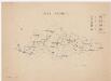
Fischenthal bis Rorbas: Tössgebiet; Übersichtsplan
1 : 200000 Mit Flächenangaben zu den Gemeinden. Ohne Datumsangabe.
Bodenverbesserungen im Kanton Zürich
1 : 280000 1 Karte zusammengestellt von J. Girsberger
Carte des Cantons Zürich
1 : 275000 1 Karte gezeichnet und gestochen von J.H. Bachofen ; hrsg. und im Verlag von J.H. Locher
Karte des Kantons Zürich
1 : 250000 1 Karte
Karte des Zürichgebiets nach Murdochs Entwerfungsart
Aktualisierte Ausgabe der ersten Auflage von 1803. Mit Distriktseinteilung (5 Distrikte) und Erklärung der Zeichen. Orell Füssli und Cie., in Zürich
Karte des Kantons Zürich mit seinen Untertanengebieten und Grenzen von 1765
1 : 240000 Originaltitel: Canton Zürich sive Illustris Helvetiorum Respublica Tigurina cum subditis suis et confinibus. Verkleinerung der von Gabriel Walser verfertigten Originalkarte. Mit Erklärung der Zeichen und Nebenkarte der Herrschaft Sax-Forstegg. Vermutlich: Walser, Gabriel (1695-1776), reformierter Pfarrer, von Teufen AR Herausgeber: Homännische Erben, in Nürnberg (Deutschland)
Canton Zürich sive illustris helvetiorum respublica Tigurina cum subditis suis et confinibus
1 Karte : Kupferdruck ; 23 x 26 cm Walser Homännische Erben
Schulkarte des Kantons Zürich
1 : 125000 1 Karte von J. Randegger
Canton de Zurich
1 : 291000 1 Karte dressé par Th. Duvotenay ; gravé par C. Dyonnet ; Bénard sc.
Schulkarte des Kantons Zürich
1 : 125000 1 Karte von J. Randegger
<<Der>> Kanton Zürich
1 : 180000 1 Karte als Lehrmaterial der Erziehungsanstalt im Seefeld auf Stein gezeichnet von F. Beust