Maps of Zurich

<<Der>> Canton Zürich
1 : 230000 1 Karte
Canton Zürich
1 : 230000 1 Karte gezeichnet und herausgegeben von Hch. Keller ; gest. v. J. Scheurmann
<<Der>> Canton Zürich
1 : 230000 1 Karte
Canton Zürich
1 : 240000 1 Karte gezeichnet und herausgegeben von Hch. Keller
Karte des Kantons Zürich
1 : 250000 1 Karte
<<Das>> Erscheinen der Maikäfer im Kanton Zürich im Jahre 1876
1 : 270000 1 Karte
Bodenverbesserungen im Kanton Zürich
1 : 280000 1 Karte zusammengestellt von J. Girsberger
Karte des Kantons Zürich
1 : 250000 1 Karte
Carte des Cantons Zürich
1 : 275000 1 Karte gezeichnet und gestochen von J.H. Bachofen ; hrsg. und im Verlag von J.H. Locher
Karte des Kantons Zürich
1 : 250000 1 Karte
Canton de Zurich
1 : 291000 1 Karte dressé par Th. Duvotenay ; gravé par C. Dyonnet ; Bénard sc.
Canton Zürich
1 : 230000 1 Karte gezeichnet und herausgegeben von Hch. Keller ; gest. v. J. Scheurmann
Canton Zürich
1 : 230000 1 Karte gezeichnet und herausgegeben von Hch. Keller ; gest. v. J. Scheurmann
[Geologische Karte des Kantons Zürich]
1 : 250000 1 Karte
Canton Zürich sive illustris Helvetiorum respublica Tigurina cum subditis suis et confinibus
1 : 135000 1 Karte recenter delineata à Gabriele Walsero
Canton Zürich
1 : 240000 1 Karte gezeichnet und herausgegeben von Hch. Keller
<<Der>> Canton Zürich
1 : 230000 1 Karte
Karte des Zürichgebiets nach Murdochs Entwerfungsart
Mit Distriktseinteilung (15 Distrikte) und Erklärung der Zeichen. Orell Füssli und Cie., in Zürich Stich: Senn
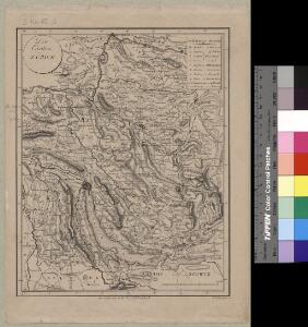
<<Der>> Canton Zürich
1 : 230000 1 Karte H. Keller del. ; J.J. Scheurmann sc.
Wegekarte vom Canton Zürich
1 : 240000 1 Karte gezeichnet und herausgegeben von Hch. Keller ; gest. v. J. Scheurmann
<<Der>> Canton Zürich mit seinen nähern Angränzungen
1 : 118000 1 Karte gezeichnet und herausgegeben von Heinrich Keller ; gest. v. J. Scheurmann
Karte des Zürichgebiets nach Murdochs Entwerfungsart
Aktualisierte Ausgabe der ersten Auflage von 1803. Mit Distriktseinteilung (5 Distrikte) und Erklärung der Zeichen. Orell Füssli und Cie., in Zürich
Atlas novus Reipublicae Helveticae
1 Atlas ([40] Bl., 97 S.) bey Orell, Gessner und Compagnie, Zürich
<<Der>> Canton Zürich
1 : 230000 1 Karte Orell Füssli & Cp., Zürich
<<Der>> Kanton Zürich
1 : 180000 1 Karte als Lehrmaterial der Erziehungsanstalt im Seefeld auf Stein gezeichnet von F. Beust
Tabula topographica parochiarum synodo Tigurinae obstrictarum opera
1 : 190000 1 Karte Joh. Heinr. Freytag
Karte des Kantons Zürich
1 : 125000 1 Karte J.M. Ziegler ; [gestochen von R. Leuzinger ; Schrift v. P. Steiner]
Karte des Kantons Zürich
1 : 125000 1 Karte J.M. Ziegler ; gestochen von R. Leuzinger ; Schrift v. P. Steiner
Canton Zürich sive illustris Helvetiorum respublica Tigurina cum subditis suis et confinibus
1 : 275000 1 Karte [Gabriel Walser?]