Maps of Zurich

Canton de Zurich
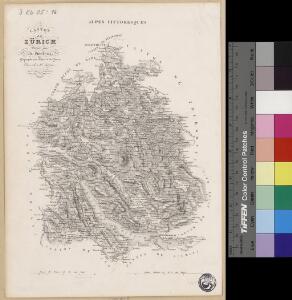
1 : 291000 1 Karte dressé par Th. Duvotenay ; gravé par C. Dyonnet ; Bénard sc.
Carte des Cantons Zürich
1 : 275000 1 Karte gezeichnet und gestochen von J.H. Bachofen ; hrsg. und im Verlag von J.H. Locher
Canton Zürich
1 : 240000 1 Karte gezeichnet und herausgegeben von Hch. Keller
<<Der>> Canton Zürich
1 : 230000 1 Karte
<<Der>> Canton Zürich
1 : 230000 1 Karte H. Keller del. ; J.J. Scheurmann sc.
Karte des Kantons Zürich
1 : 250000 1 Karte
Bodenverbesserungen im Kanton Zürich
1 : 280000 1 Karte zusammengestellt von J. Girsberger
Canton Zürich
1 : 230000 1 Karte gezeichnet und herausgegeben von Hch. Keller ; gest. v. J. Scheurmann
<<Der>> Canton Zürich
1 : 230000 1 Karte H. Keller del. ; J. J. Scheurmann sc.
Karte des Kantons Zürich
1 : 250000 1 Karte
Karte des Kantons Zürich
1 : 250000 1 Karte
[Karte des Kantons Zürich]
1 : 250000 1 Karte
<<Der>> Canton Zürich
1 : 230000 1 Karte H. Keller del. ; J.J. Scheurmann sc.
[Karte des Kantons Zürich]
1 : 250000 1 Karte
[Geologische Karte des Kantons Zürich]
1 : 250000 1 Karte
<<Der>> Canton Zürich
1 : 230000 1 Karte
Atlas novus Reipublicae Helveticae
1 Atlas ([40] Bl., 97 S.) bey Orell, Gessner und Compagnie, Zürich
Atlas der alten Eidgenossenschaft in 20 Karten: Kanton Zürich
Originaltitel: Canton Zürich sive Illustris Helvetiorum Respublica Tigurina cum Subditis suis et Confinibus. Mit Erklärung der Zeichen sowie Nebenkarte der Landvogtei Sax. Zeichnung: Walser, Gabriel (1695-1776), reformierter Pfarrer, von Teufen AR Herausgeber: Homännische Erben
Canton Zürich sive illustris Helvetiorum respublica Tigurina cum subditis suis et confinibus
1 : 275000 1 Karte [Gabriel Walser?]
Kanton Zürich: Trigonometrisches Netz
1 : 100000 Auftraggebung: Eidgenössisches Topographisches Büro, in Bern Jacky, W., Ingenieur; Pfändler, L., Ingenieur
Canton Zürich
1 : 240000 1 Karte gezeichnet und herausgegeben von Hch. Keller
Karte des Kantons Zürich
1 : 125000 1 Karte J.M. Ziegler ; gestochen von R. Leuzinger ; Schrift von P. Steiner
Tabula topographica parochiarum synodo Tigurinae obstrictarum opera
1 : 190000 1 Karte Joh. Heinr. Freytag
Karte des Kantons Zürich
1 : 125000 1 Karte J.M. Ziegler ; gestochen von R. Leuzinger ; Schrift von P. Steiner
Canton Zürich sive illustris Helvetiorum respublica Tigurina cum subditis suis et confinibus
1 : 275000 1 Karte [Gabriel Walser?]
Karte des Zürichgebiets nach Murdochs Entwerfungsart
Mit Distriktseinteilung (15 Distrikte) und Erklärung der Zeichen. Orell Füssli und Cie., in Zürich Stich: Senn
Canton Zürich
1 : 230000 1 Karte gezeichnet und herausgegeben von Hch. Keller ; gest. v. J. Scheurmann
Geographische Vertheilung der landwirthschaftlichen Bevölkerung und der wichtigsten Fabriketablissements
1 : 125000 1 Karte entworfen von C.K. Müller ; Topogr. Anst. v. Wurster, Randegger & Cie. in Winterthur
<<Der>> Kanton Zürich
1 : 200000 1 Karte [gez. v. Beust]