Maps of Crystal Mountains

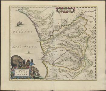
REGNA | CONGO | et | ANGOLA.
[Amsterdam : Joan Blaeu]
Afrique équatoriale Francaise
1 : 5000000 Afrika střední Barralier, Emmanuel Emile Larose
Regna Congo et Angola
1 : 3000000 Annotatie: Origineel is Blad 209 in atlas factice; Annotatie geografische gegevens: Schaalstok op kaart: 2 Milliaria Germanica Communia (=7,2 cm) [Amstelædami] : [Labore et Sumptibus Ioannis Blaev]
Carte géologique de l'Afrique équatoriale française. Planche sud
1 : 5000000 Loir, Erasme, géologue 18..-19.. Paris : Larose
Carte de Angola: esboço / Ministerio das Colonias, Comissâo de Cartografia
1 Mapa. Ministerio das Colonias (Portugal). Comissâo de Cartografia
Afrique equatoriale Française
1 : 2000000 Kongo (Brazzaville) Meunier, A. Courtier
Anzico. Afrique 38.
1 : 1641836 Vandermaelen, Philippe, 1795-1869
Congo et Angola. Afrique 41.
1 : 1641836 Vandermaelen, Philippe, 1795-1869
Colonie du Gabon. Afrique Equatoriale Française
1 : 1000000 Meunier, A., cartographe Paris : Ministère des colonies
Carte internationale du monde au 1.000.000 E
1 : 1000000 Kinshasa (Kongo) Service géographique du Ministere des colonies
Matamba. Afrique 42.
1 : 1641836 Vandermaelen, Philippe, 1795-1869
Provincia de Angola Porto do Ambriz à Baía dos Elefantes
1 : 750000 Hydrographic Map Instituto Hidrográfico Portugal Instituto Hidrográfico Portugal
Partie du Congo. Afrique 39.
1 : 1641836 Vandermaelen, Philippe, 1795-1869
Croquis hypsométrique du Congo occidental
1 : 1000000 Kongo (Kinshasa) Delhaye, F. Sluys, M. E. Patesson
Karte des Handelsgebiets von West-Aequatoreal-Afrika
1 : 780000 L. Friedrichsen Hambourg : Friederichsen
Région des cours supérieurs de l'Ogôoué, de l'Alima et de la Licona (Carte provisoire)
1 : 1000000 Brazza, Pierre Savorgnan de 1852-1905 Paris : Société de géographie
Cours du Congo entre le Pool et Bonga, rivières Alima et Nkeni
1 : 308333 Rouvier, Charles 18..-.... Paris : imp. Lemercier et Cie
Cours du Congo entre Bonga et l'Equateur, rivières Ubangui et Sangha
1 : 308333 Rouvier, Charles 18..-.... Paris : imp. Lemercier et Cie
Région du chemin de fer Congo-océan (esquisse topographique). Feuille 1 : Brazzaville-Kimbédi
1 : 250000 Lombard, Jean 1895-.... Paris : H. Barrère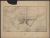
Carte du bassin du Niari (Loudima-Comba)
1 : 250000 Lamy, François 1858-1900 Paris : Aron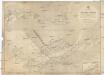
Afrika west coast
1 : 160000 Kongo (řeka) Vidal, R.N. Medlycott, Mervyn Bradford Admirality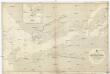
Afrika west coast
1 : 73000 Kongo (řeka) Medlycott, Mervyn Bradford Admirality
Provincia de Angola Porto de Luanda à Ponta das Palmeiras
1 : 60000 Hydrographic Map Instituto Hidrográfico Portugal Instituto Hidrográfico Portugal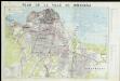
Plan de ville de Kinshasa

De baij en stadt Loand de St. Paulo geleegen aen de kust van Angola in Guinea
Angola Gerard van Keulen
Provincia de Angola Baía de Benguela
1 : 20000 Hydrographic Map Instituto Hidrográfico Portugal Instituto Hidrográfico Portugal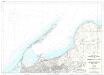
Provincia de Angola Porto de Luanda
1 : 15000 Hydrographic Map Instituto Hidrográfico Portugal Instituto Hidrográfico Portugal
Provincia de Angola Enseada do Quicombo
1 : 15000 Hydrographic Map Instituto Hidrográfico Portugal Instituto Hidrográfico Portugal
Provincia de Angola Porto do Lobito
1 : 10000 Hydrographic Map Instituto Hidrográfico Portugal Instituto Hidrográfico Portugal