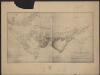
Maps of Brazzaville

Région du chemin de fer Congo-océan (esquisse topographique). Feuille 1 : Brazzaville-Kimbédi
1 : 250000 Lombard, Jean 1895-.... Paris : H. Barrère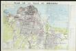
Plan de ville de Kinshasa
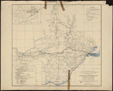
Carte du bassin du Niari (Loudima-Comba)
1 : 250000 Lamy, François 1858-1900 Paris : Aron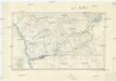
Croquis hypsométrique du Congo occidental
1 : 1000000 Kongo (Kinshasa) Delhaye, F. Sluys, M. E. Patesson
Anzico. Afrique 38.
1 : 1641836 Vandermaelen, Philippe, 1795-1869
Carte de Angola: esboço / Ministerio das Colonias, Comissâo de Cartografia
1 Mapa. Ministerio das Colonias (Portugal). Comissâo de Cartografia
Afrique equatoriale Française
1 : 2000000 Kongo (Brazzaville) Meunier, A. Courtier
Afrique équatoriale Francaise
1 : 5000000 Afrika střední Barralier, Emmanuel Emile Larose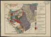
Carte géologique de l'Afrique équatoriale française. Planche sud
1 : 5000000 Loir, Erasme, géologue 18..-19.. Paris : Larose
Západní polovice rovníkové Afriky s výzpytnými cestami po suchu a po vodě Henryho Stanleye v letech 1874-1877
1 : 3000000 Afrika střední
REGNA | CONGO | et | ANGOLA.
[Amsterdam : Joan Blaeu]
West Africa.
1 : 2500000 Andree, Richard; Times (London, England)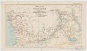
Map of a portion of South Africa : illustrative of Lieut. Cameron's route from lake Tangayika to the west coast
1 : 5000000 Ravenstein, Ernst Georg, 1834-1913 Geogr. Mag.
Central Africa - western section.
1 : 5000000 John Bartholomew and Son
Triangulations principales du Congo Belge
1 : 4000000 Ministére des colonies, Service cartographique
Der Congo-Staat nach seiner Districts-Eintheilung
1 : 8000000 Kongo (Kinshasa) A. Hartleben
Congo Belge
1 : 5000000 Kongo (Kinshasa) Institut cartographique militaire
Spezial-Karte von Afrika
1 : 4000000 Blatt 7 Habenicht, Hermann Perthes
Carte de l'Etat indépendant du Congo [et] Carte du Bassin du Congo
1 : 8000000 Wauters, A.-J. 1845-1916; Institut national de géographie. Belgique Bruxelles : Institut national de géographie
Western half of Equatorial Africa and the expeditions on land and sea by Henry M. Stanley during 1874-77

Stanley's Discoveries in Africa.
1 : 17500000 Colton, G.W.
Carte géologique de l'Afrique équatoriale Franc[ai]se
1 : 5000000 Afrika střední Barralier, Emmanuel Millet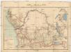
Carte du bassin du Congo
1 : 4000000 Kongo (Kinshasa) Kiepert, Richard Droysen, Wilhelm Dietrich Reimer
Regna Congo et Angola. [Karte], in: Novus atlas absolutissimus, Bd. 6, S. 180.
1 Karte aus Atlas Janssonius Offizin
Carte du Congo Belge
1 : 4000000 Belgie Falk fils
Afrique equator.le franc.se
1 : 3000000 Afrika střední Meunier, Alexandre
Carte du réseau fluviale navigable de l'Afrique equatoriale française
1 : 3000000 Afrika střední
Charte von Nieder Guinea
Angola
CHARTE von NIEDER GUINEA
Angola