Maps of Luanda
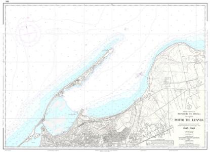
Provincia de Angola Porto de Luanda
1 : 15000 Hydrographic Map Instituto Hidrográfico Portugal Instituto Hidrográfico Portugal
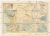
De baij en stadt Loand de St. Paulo geleegen aen de kust van Angola in Guinea
Angola Gerard van Keulen
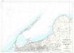
Provincia de Angola Porto de Luanda à Ponta das Palmeiras
1 : 60000 Hydrographic Map Instituto Hidrográfico Portugal Instituto Hidrográfico Portugal
Provincia de Angola Porto do Ambriz à Baía dos Elefantes
1 : 750000 Hydrographic Map Instituto Hidrográfico Portugal Instituto Hidrográfico Portugal
Congo et Angola. Afrique 41.
1 : 1641836 Vandermaelen, Philippe, 1795-1869
Carte de Angola: esboço / Ministerio das Colonias, Comissâo de Cartografia
1 Mapa. Ministerio das Colonias (Portugal). Comissâo de Cartografia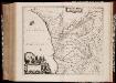
Regna Congo et Angola
1 : 3000000 Annotatie: Origineel is Blad 209 in atlas factice; Annotatie geografische gegevens: Schaalstok op kaart: 2 Milliaria Germanica Communia (=7,2 cm) [Amstelædami] : [Labore et Sumptibus Ioannis Blaev]
Carta de Angola
1 : 2000000 Wall Map Junta de Investigações do Ultramar Governo Geral de Angola
Carta do Sul de Angola compreendendo a regiao situada ao sul do paralello 14\00BA
1 : 500000 Angola Ministerio das Colonias, Comissao de Cartografia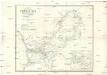
Carte d'une partie de l'Afrique équinoxiale
1 : 3300000 Angola Brué, A. M. Jules Renouard
REGNA | CONGO | et | ANGOLA.
[Amsterdam : Joan Blaeu]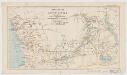
Map of a portion of South Africa : illustrative of Lieut. Cameron's route from lake Tangayika to the west coast
1 : 5000000 Ravenstein, Ernst Georg, 1834-1913 Geogr. Mag.
Central Africa - western section.
1 : 5000000 John Bartholomew and Son
Triangulations principales du Congo Belge
1 : 4000000 Ministére des colonies, Service cartographique
Der Congo-Staat nach seiner Districts-Eintheilung
1 : 8000000 Kongo (Kinshasa) A. Hartleben
Congo Belge
1 : 5000000 Kongo (Kinshasa) Institut cartographique militaire
Spezial-Karte von Afrika
1 : 4000000 Blatt 7 Habenicht, Hermann Perthes
Carte de l'Etat indépendant du Congo [et] Carte du Bassin du Congo
1 : 8000000 Wauters, A.-J. 1845-1916; Institut national de géographie. Belgique Bruxelles : Institut national de géographie
Western half of Equatorial Africa and the expeditions on land and sea by Henry M. Stanley during 1874-77

Stanley's Discoveries in Africa.
1 : 17500000 Colton, G.W.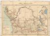
Carte du bassin du Congo
1 : 4000000 Kongo (Kinshasa) Kiepert, Richard Droysen, Wilhelm Dietrich Reimer
Regna Congo et Angola. [Karte], in: Novus atlas absolutissimus, Bd. 6, S. 180.
1 Karte aus Atlas Janssonius Offizin
Carte du Congo Belge
1 : 4000000 Belgie Falk fils
Charte von Nieder Guinea
Angola
CHARTE von NIEDER GUINEA
Angola
Nieder Guinea, W. Mittel-Africa.
1 : 5500000 Weiland, C. F. (Carl Ferdinand), d. 1847
[Recto], uit: Congo physique, économique et administratif / dressé par A. Michiels
1 : 6000000 titelvariant: Nouvelle carte du Congo au 1:6.000.000; Notre colonie; Annotatie: Omslagtitel: Nouvelle carte du Congo au 1:6.000.000; Suppl. bij: Notre colonie : géographie et notice historique / Albert Michiels. - 4e éd. - Bruxelles : Mertens ; [etc.], 1913 Michiels, Albert Bruxelles : Mertens [etc.]
Spezial - karte von AfricaSekt. Congo (7)
1 : 4000000 1 full d'1 mapa en 10 fulls i estoig Hermann Habenicht; Justus Perthes
Congo Belge
1 : 4000000 Afrika střední I.C.M.