Maps of Grand Est

[Duché de Lorraine, Franche Comté, Duché de Wurtemberg, Le Suisse]
1 : 740000 [S.l.] : [s.n.]
Le Cours de la Riviere du Rhein
1 : 1100000 Mollova mapová sbírka Sanson, Guillaume Mortier, Pierre
Accuratissima Rheni superioris Mosae et Mosellae tabula ac minores in eosdem influentes fluvii
1 : 950000 1 Karte : Kupferdruck ; 49 x 57 cm Danckerts, Theodorus [Danckerts]
Le Cours de la Riviere du Rhein
1 : 1100000 Mollova mapová sbírka Sanson, Guillaume Schenk, Peter I
Il Corso Del Fivme Reno :
Mollova mapová sbírka Cantelli, Giacomo Barbey, Antonio De Rossi, Giovanni Giacomo
Postarum seu Veredariorum Stationes Per Germaniam et Provincias Adiacentes.
1 : 400000 Mollova mapová sbírka Danckerts, Justus Danckerts, Cornelis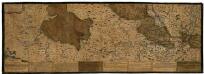
Rhenus Bicornis hoc est Totius Rheni tractus delineatio
Mollova mapová sbírka Vopel, Caspar Tscherning, Johann
Tabula Geographica qua Pars Meridionalis sive Superior Rheni, Mosae et Mosellae
1 : 1100000 Mollova mapová sbírka Visscher, Nicolaes Jansz. Visscher, Nicolaus
Tabula Geographica qua Pars Meridionalis sive Superior Rheni, Mosae et Mosellae
1 : 1100000 Mollova mapová sbírka Visscher, Nicolaes Jansz. Visscher, Nicolaus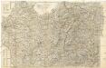
Supplement zur Straßsen-Karte der westlichen Alpen
1 : 700000 Západní Alpy Oesterreichischer Generalquartiermeisterstab
Supplement zur Straßsen-Karte der westlichen Alpen
1 : 700000 Západní Alpy Oesterreichischen Generalquartiermeisterstabs
Supplement zur Strassen-Karte der westlichen Alpen
1 : 700000 Západní Alpy K. u. k. Militärgeographisches Institut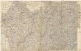
Supplement zur Strassen-Karte der Westlichen Alpen
1 : 700000 Západní Alpy
Carte von Lottringen Elsass Franche Comte Schweizerland und Würtenberg
1 Karte : Kupferdruck ; 47 x 62 cm Riegel Christoph Riegel
Carte von Lottringen Elsass, Franche Comté Schweizerland und Würtenberg
1 Karte : Kupferdruck ; 47 x 62 cm Riegel beÿ Christoph Riegel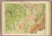
France - north-eastern section, environs of Paris.
1 : 1000000 John Bartholomew & Co.
Landgraviatus Alsatiae
1 : 340000 Alsasko (Francie) Homann, Johann Baptist Ioh. Baptista Homanno
Landgraviatus Alsatiae
1 : 340000 Alsasko (Francie) Homann, Johann Baptist J. B. Homann
Landgraviatus Alsatiae
1 : 340000 Alsasko (Francie) Homann, Johann Baptist Ioh. Baptista Homanno
[Deutschland und der gröste Theil der umliegenden Staaten oder Mittel-Europa]
1 : 1100000 35 Karten [nach astronomischen Ortsbestimmungen und den besten Special-Karten, mit Rücksicht auf die neuesten Grenz-Bestimmungen entworfen, zufolge der Wiener Congress-Akte, des Pariser Friedens vom 21ten Nov. 1815, und der neuesten Austauschungen 1816 von H.H. Gotthold] ; [geschrieben und gestochen von H. Kliewer] ; sämtliche Gebürge im Atlas sind gezeichnet und gestochen von Paulus Schmidt, so wie auch die Sectionen 3,11,16,18,19,21,25,26,31 von demselben gestochen worden [Simon Schropp & Co.], [Berlin]
<<Die>> vierdt Landtafel haltet inn die alt Helvetiam Iulii Cesaris mit iren Anstössen wie die im vierdten Buoch verzeichnet wirt
1 : 700000 1 Karte [Johannes Stumpf] [Froschauer], [Zürich]
Teatre de la Guerre sur le Rhein, Moessele, Mayn & Necker
1 : 420000 Mollova mapová sbírka Sanson, Guillaume Covens, Johannes I
Kurtz verzeichnete Vorstellung dess alten Helvetier-Lands mit ihren Anstoessen nach Julii Caesaris Beschreibung
1 Karte [Johannes Stumpf] [Verlag nicht ermittelbar], [Erscheinungsort nicht ermittelbar]
Helvetiae descriptio
1 Karte : Kupferdruck ; 34 x 44 cm Tschudi; Ortelius s.n.
Helvetiae descriptio
1 Karte : Kupferdruck ; 35 x 45 cm Tschudi; Ortelius s.n.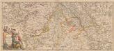
Totius Fluminis Rheni Novissima Descriptio [Karte, Teil 1], in: Novus atlas absolutissimus, Bd. 2, S. 150.
1 Karte aus Atlas Janssonius Offizin
Partie des Grisons du haut Rheinthal et ses frontieres au Gouvernement d' Arlberg et Tyrol.
From Atlas Suisse. Levé et dessiné par J. H. Weiss aux fraix de J. R. Meyer á Aarau dans les années 1786 á 1802. Gravée par Guerin, Eichler, et Scheurmann.
Kurtz verzeichnete Vorstellung dess alten Helvetier-Lands mit ihren Anstoessen nach Iulii Caesaris Beschreibung
1 : 700000 1 Karte [Johannes Stumpf] [Verlag nicht ermittelbar], [Zürich?]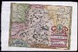
Provincia Helvetiae
Johannes a Montecalerio
![[Duché de Lorraine, Franche Comté, Duché de Wurtemberg, Le Suisse]](https://images-2.georeferencer.com/images/iiif/531976347397/full/,300/0/native.jpg)

