Maps of Grand Est

Teatre de la Guerre sur le Rhein, Moessele, Mayn & Necker
1 : 420000 Mollova mapová sbírka Sanson, Guillaume Covens, Johannes I
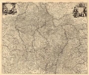
Rhenus Bicornis hoc est Totius Rheni tractus delineatio
Mollova mapová sbírka Vopel, Caspar Tscherning, Johann
Nova tractus totius Rheni.T
1 : 740000 Evropa západní Funck, David David Funck
Nova Tractus Totius Rheni T.
1 : 740000 Mollova mapová sbírka Funck, David Funck, David
Kriegsschauplatz oder Graenzkarte zwischen Deutschland u. Frankreich enthaltend die Oesterreichische Niederlanden, das Bisthum Lüttich, Chur Cöln, Trier, Maynz, und Pfaltz, Ober, und Chur Rhein, Fränkischer, und Schwäbisher Kreis, einen Theil von Westphalen, Hessen, Cassel, Darmstadt, und Zweybrücken nebst Breisgau, das Französische Flandern, Artois, Henegau, Picardie, Isle de France mit Paris, Champagne, Lothringen und Elsas
1 : 680000 Alsasko (Francie) Ioh. Walch
Kriegsschauplatz oder Graenzkarte zwischen Deutschland u. Franckreich
1 : 680000 Alsasko (Francie) Walch, Johann bey Joh. Walch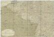
Kriegstheater oder Graenzkarte zwischen Deutschland und Frankreich
1 : 500000 Belgie
Kriegsschauplatz oder Graenzkarte zwischen Deutschland u. Frankreich enthaltend die Oesterreichische Niederlanden, das Bisthum Lüttich, Chur Cöln, Trier, Maynz, und Pfaltz, Ober, und Chur Rhein, Fränkischer, und Schwäbisher Kreis, einen Theil von Westphalen, Hessen, Cassel, Darmstadt, und Zweybrücken nebst Breisgau, das Französische Flandern, Artois, Henegau, Picardie, Isle de France mit Paris, Champagne, Lothringen und Elsas
1 : 680000 Alsasko (Francie) Ioh. Walch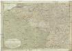
Kriegstheater oder Graenzkarte zwischen Deutschland und Frankreich
1 : 660000 Alsasko (Francie) Müller, Franz Artaria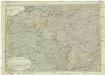
Kriegstheater oder Graenzkarte zwischen Deutschland und Frankreich
1 : 1015000 Evropa západní Müller, Franz bey Artaria

Martis Area et Alea per Tractum Rheni, Mosellae, ac Mosae in qua per plurimos annorum tractus variante eventu saepius certatum, Curatißime designata
1 : 1100000 Mollova mapová sbírka Seutter, Matthäus Seutter, Matthäus

Schauplatz des dermahligen Krieges, 1793
1 : 2775000 Belgie Stöber, Joseph
Der Rhein, die Maass und Mosel mit den anliegenden Ländern des Ober-Chur und Nieder-Rhein. wie auch des Burgundischen Kreises ing. Elsass ünd Lothringen &cc
1 : 902000 Alsasko (Francie) Güssefeld, Franz L. bey denen Homaen[n]ischen Erben
Theatrum belli Rhenani
1 : 1100000 Evropa západní Homann, Johann Baptist Ioan. Baptist Homann
Theatrum belli Rhenani
1 : 1260000 Maas Homann, Johann Baptist Ioan. Baptista Homan
Theatrum Belli Rhenani
1 : 1100000 Mollova mapová sbírka Homann, Johann Baptist Homann, Johann Baptista
Fluviorum Rheni Mosae ac Mosellae novissima exhibitio
1 : 1100000 Alsasko (Francie) Schenk, Pieter Petro Schenk
Fluviorum Rheni Mosae ac Mosellae Novissima Exhibitio
1 : 1100000 Mollova mapová sbírka Schenk, Pieter Schenk, Peter I
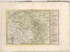
Sedes ac theatrvm bellorvm per plurimos annos in Regionibus Rheni, Mosae ac Mosellae
1 : 920000 Alsasko (Francie) Bodenehr, Gabriel Tobias Conrad Lotter
Accurate Land Charte des Rheins Mossel und Neckar-Stroms
1 : 845700 Mosela, řeka-oblast Christoph Riegel
Martis Area et Alea per Tractum Rheni, Mosellae, ac Mosae, in qua per plurimos annorum tractus variante eventu saepius certatum, Curatißime designata caelo et studio
1 : 11100000 Mollova mapová sbírka Seutter, Matthäus Seutter, Matthäus
Totius Fluminis Rheni Novissima Descriptio
1 : 820000 Mollova mapová sbírka Danckerts, Justus Danckerts, Justus
Totius Fluminis Rheni Novissima Descriptio
1 : 790000 Mollova mapová sbírka Visscher, Nicolaes Jansz. Schenk, Peter I
Totius fluminis Rheni novissima descriptio
1 : 820000 Evropa západní Danckerts, Justus I. Danckerts
Secunda Rheni Et IX. Nova Tabula. [Karte], in: Claud. Ptolemaeus. Geographia lat. cum mappis [...], S. 362.
1 Karte aus Atlas Münster, Sebastian [und Ptolemaeus, Claudius]
Der gantze Rhein Strom Von Seinem Ursprung biß zu seinem Ausfluß
1 : 1100000 Mollova mapová sbírka Haupt, Gottfried Jacob Haupt, Gottfried Jacob