Maps of Netherlands

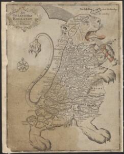
Het Graafschap Hollandt.
1 : 4500000 Te Amsterdam : bij B. Mourik
Algemeene kaarte der Nederlandsche Republiek, verdeeld naar derzelver kerkelyk bestuur
door W.A. Bachiene ... J. van Jagen sculps. 1767. Amsterdam : bij D. onder de Linden
[25]. Nederland : de dijken weggedacht ..., uit: Geologische kaart van Nederland : schaal van 1:200.000 / door W.C.H. Staring ; uitgevoerd door het Topographisch Bureau van Oorlog ; uitgegeven op last van Zijne Majesteit Den Koning
Annotatie: Impressum ontleend aan omslag; Kaart "Nederland de dijken weggedacht" [kaart 25] en kaart 13 (bladwijzer) vermelden het jaar 1869; Kaart 'Limburg en de Hesbaije' (bladnr. 26) vermeldt het jaar 1868; Blad 5/9 ontbreekt Topographische Inrichting, 's-Gravenhage; Topographisch Bureau Haarlem : A.C. Kruseman
Belgii faederati nova descriptio
1 : 700000 auctore Jodoco Hondio. T'Amsterdam : by Clemendt de Jonghe exc.
Belgica Foederata
1 : 610000 Mollova mapová sbírka Lotter, Tobias Conrad Lotter, Tobias Conrad
Des Burgundischen Creisses Nordlicher Theil oder Vereinigte Niederlande
1 : 2200000 Mollova mapová sbírka Weigel, Christoph Weigel, Christoph I. - dědici
Belgium foederatum
1 Karte : Kupferdruck ; 47 x 55 cm Seutter Matthäus Seutter
Seven United Provinces.
1 : 1550000 Bowen, Emanuel
BELGICA | FOEDERATA
[Amsterdam : Joan Blaeu]

Belgium foederatum / emendatius auctum et novissimé editum per Iustinum Danckerts Amstelodami
1 : 500000 Annotatie: Cum privil. Ordin. Holl. et Westfrisiae; Annotatie geografische gegevens: Met 2 schaalstokken Justus Danckertsz 1635-1701 [Amsterdam : Justus Danckerts]
Belgium foederatum
1 : 630000 1 Karte : Kupferdruck ; 49 x 55 cm Danckerts, Justus [Danckerts]
Belgii Pars Septentrionalis communi nomine Vulgo Hollandia nuncupata
1 : 650000 Mollova mapová sbírka Homann, Johann Baptist Homann, Johann Baptista - dědici
Belgium Foederatum
1 : 620000 Mollova mapová sbírka Visscher, Nicolaes Schenk, Peter II
Seven United Provinces.
1 : 1460000 Bowen, Frances
Karte der itzo vereinigten Niederlande
1 : 990000 Nizozemsko
The United Provinces or Netherlands
1 : 1500000 Mollova mapová sbírka Moll, Herman Moll, Hermann
Holland.
1 : 1330560 Tallis, J. & F.
Belgium Foederatum mendatè auctum et novissimè editum [Karte], in: Novus atlas absolutissimus, Bd. 3, S. 165.
1 Karte aus Atlas Janssonius Offizin
Carte nouvelle des Provinces Unies des Pais Bas dressée suivant les dernières observations = Nieuwe kaart van de VII Provintien naar de nieuwste waarneemingen.
1 : 580000 Te Amsterdam : bij I. Covens & Zoon
Nieuwe algemeene kaart der Bataafsche Republiek : verdeeld in 94 districten bevattende ieder nagenoeg 20000 zielen
1 : 1400000 C. Covens delin. C. van Baarsel sculps. Te Amsterdam : bij Mortier Covens & Zoon
Belgica foederata complectens septem provincias, ducatum Geldriae, comitatus Hollandiae et Zeelandiae dioec. traject. transisul. Groningam et Frisiam et circumjacentes provincias mappa geographica
1 : 610000 Belgie Lotter, Tobias Conrad per Tobia[m] Conr. Lotter
Belgica foederata complectens septem provincias, ducatum Geldriae, comitatus Hollandiae et Zeelandiae dioec. traject. transisul. Groningam et Frisiam et circumjacentes provincias mappa geographica
1 : 610000 Belgie Lotter, Tobias Conrad Lotter, Matthäus Albrecht per Tobia[m] Conr. Lotter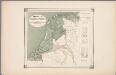
25. Nederland : de dijken weggedacht ..., uit: Geologische kaart van Nederland / door W.C.H. Staring ; bew. aan de Topographische Inrichting
1 : 200000 Winand Carel Hugo Staring 1808-1877; Topographische Inrichting, 's-Gravenhage 's-Gravenhage : Belinfante
Nieuwe kaart van het Koningrijk Holland verdeeld in X Departementen.
1 : 570000 Te Amsterdam : bij Mortier Covens en Zoon
Nieuwe kaart der Vereenigde Nederlanden
1 : 900000 Amsterdam : by Isaak Tirion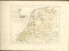

Belgium foederatum
1 : 625000 Maastricht (Nizozemsko) Visscher, Nicolaes Jansz. Schenk, Pieter P. Schenk iunior
Belgium foederatum
1 : 625000 Maastricht (Nizozemsko) Visscher, Nicolaes Jansz. par Nicolaum Visscher