Maps of Netherlands

Belgii faederati nova descriptio
1 : 700000 auctore Jodoco Hondio. T'Amsterdam : by Clemendt de Jonghe exc.
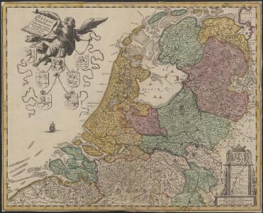
Belgii Pars Septentrionalis communi nomine Vulgo Hollandia nuncupata
1 : 650000 Mollova mapová sbírka Homann, Johann Baptist Homann, Johann Baptista - dědici
Belgium Foederatum
1 : 620000 Mollova mapová sbírka Visscher, Nicolaes Schenk, Peter II
Belgica Foederata complectens septem Provincias,
1 : 610000 Mollova mapová sbírka Valk, Gerhard Valck, Gerard
Nieuwe algemeene kaart der Bataafsche Republiek : verdeeld in 94 districten bevattende ieder nagenoeg 20000 zielen
1 : 1400000 C. Covens delin. C. van Baarsel sculps. Te Amsterdam : bij Mortier Covens & Zoon
Belgium foederatum
1 Karte : Kupferdruck ; 47 x 55 cm Seutter Matthäus Seutter
BELGICA | FOEDERATA
[Amsterdam : Joan Blaeu]

Belgica Foederata
1 : 610000 Mollova mapová sbírka Lotter, Tobias Conrad Lotter, Tobias Conrad
Belgium foederatum
1 : 625000 Maastricht (Nizozemsko) Visscher, Nicolaes Jansz. Schenk, Pieter P. Schenk iunior
Belgium foederatum
1 : 625000 Maastricht (Nizozemsko) Visscher, Nicolaes Jansz. par Nicolaum Visscher
Belgium foederatum
1 : 630000 Belgie Visscher, Nicolaus per Nicolaum Visscher
Holland (Netherlands).
1 : 1270000 Higgins, W.M.
Belgica foederata complectens septem provincias, ducatum Geldriae, comitatus Hollandiae et Zeelandiae dioec. traject. transisul. Groningam et Frisiam et circumjacentes provincias mappa geographica
1 : 610000 Belgie Lotter, Tobias Conrad per Tobia[m] Conr. Lotter
Belgica foederata complectens septem provincias, ducatum Geldriae, comitatus Hollandiae et Zeelandiae dioec. traject. transisul. Groningam et Frisiam et circumjacentes provincias mappa geographica
1 : 610000 Belgie Lotter, Tobias Conrad Lotter, Matthäus Albrecht per Tobia[m] Conr. Lotter
Des Burgundischen Creisses Nordlicher Theil oder Vereinigte Niederlande
1 : 2200000 Mollova mapová sbírka Weigel, Christoph Weigel, Christoph I. - dědici
Septem Provinciae seu Belgium Foederatum, quod generaliter audit Hollandia, secundum recentissimas observationes.
1 : 500000 Prostat Augustae Vindelicorum : apud Joannem Walch
Belgium Foederatum mendatè auctum et novissimè editum [Karte], in: Novus atlas absolutissimus, Bd. 3, S. 165.
1 Karte aus Atlas Janssonius Offizin
Algemeene kaarte der Nederlandsche Republiek, verdeeld naar derzelver kerkelyk bestuur
door W.A. Bachiene ... J. van Jagen sculps. 1767. Amsterdam : bij D. onder de Linden
Belgium foederatum
1 : 640000 Indonésie Seutter, Matthäus studio [Mattha]ei Seutteri
Belgium Foederatum auctius et emendatius
1 : 780000 Mollova mapová sbírka Seutter, Matthäus Lotter, Tobias Conrad Seutter, Matthäus
Les Provinces Unies ou la Partie Septentrionale des Pays Bas
1 : 780000 Mollova mapová sbírka Coronelli, Vincenzo Maria Loon, Herman van Nolin, Jean Baptist François
Belgii Foederati Nova Descriptio. [Karte], in: Novus atlas absolutissimus, Bd. 3, S. 28.
1 Karte aus Atlas Janssonius Offizin
[25]. Nederland : de dijken weggedacht ..., uit: Geologische kaart van Nederland : schaal van 1:200.000 / door W.C.H. Staring ; uitgevoerd door het Topographisch Bureau van Oorlog ; uitgegeven op last van Zijne Majesteit Den Koning
Annotatie: Impressum ontleend aan omslag; Kaart "Nederland de dijken weggedacht" [kaart 25] en kaart 13 (bladwijzer) vermelden het jaar 1869; Kaart 'Limburg en de Hesbaije' (bladnr. 26) vermeldt het jaar 1868; Blad 5/9 ontbreekt Topographische Inrichting, 's-Gravenhage; Topographisch Bureau Haarlem : A.C. Kruseman
Nieuwe kaart van het Koningrijk Holland verdeeld in X Departementen.
1 : 570000 Te Amsterdam : bij Mortier Covens en Zoon
Belgii pars septentrionalis communi nomine vulgo Hollandia ...
1 : 640000 edente Petro Schenkio Amstelaedami : Petrus Schenkius
Carte nouvelle des Provinces Unies des Pais Bas dressée suivant les dernières observations = Nieuwe kaart van de VII Provintien naar de nieuwste waarneemingen.
1 : 580000 Te Amsterdam : bij I. Covens & Zoon
Foederatae Belgicae tabvla
1 : 728000 Limburg (Belgie) Wit, Frederick de F. de Wit