Maps of Netherlands

Septem Provinciae seu Belgium Foederatum, quod generaliter audit Hollandia, secundum recentissimas observationes.
1 : 500000 Prostat Augustae Vindelicorum : apud Joannem Walch
Belgium Foederatum mendatè auctum et novissimè editum [Karte], in: Novus atlas absolutissimus, Bd. 3, S. 165.
1 Karte aus Atlas Janssonius Offizin
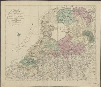
Belgica Foederata complectens septem Provincias,
1 : 610000 Mollova mapová sbírka Valk, Gerhard Valck, Gerard
Belgica Foederata
1 : 610000 Mollova mapová sbírka Lotter, Tobias Conrad Lotter, Tobias Conrad
Belgii Foederati Nova Descriptio. [Karte], in: Novus atlas absolutissimus, Bd. 3, S. 28.
1 Karte aus Atlas Janssonius Offizin
Provinces Vnies de Pays Bas
1 : 861000 Nizozemsko
A new and correct map of the seven provinces : drawn from the most approved maps and charts : the whole being regulated by astronomical observations
1 : 920000 by Eman Bowen. [London] : Tyndal

Belgii pars septentrionalis communi nomine vulgo Hollandia ... = Land caerte van ’t Verenigde Nederland met ’t gene daer onderhoort, verdeelt in syn provincien en minder verdelingen
1 : 800000 naaukeurig aangewesen en uyt de beste aantekeninge opgestelt. Ultrajecti : Cornelius Kribber
Belgii pars septentrionalis communi nomine vulgo Hollandia ...
1 : 640000 edente Petro Schenkio Amstelaedami : Petrus Schenkius
Foederatae Belgicae tabvla
1 : 728000 Limburg (Belgie) Wit, Frederick de F. de Wit

Belgii faederati nova descriptio
1 : 700000 auctore Jodoco Hondio. T'Amsterdam : by Clemendt de Jonghe exc.
Holland.
1 : 1048000 Hughes, William
Les Dix-Sept Provinces Des Pays-Bas
1 : 760000 Mollova mapová sbírka Sanson, Guillaume Sanson, Guillaume
Belgium foederatum
1 Karte : Kupferdruck ; 47 x 55 cm Seutter Matthäus Seutter
BELGICA | FOEDERATA
[Amsterdam : Joan Blaeu]
Belgium foederatum
1 : 625000 Maastricht (Nizozemsko) Visscher, Nicolaes Jansz. Schenk, Pieter P. Schenk iunior
Belgium foederatum
1 : 625000 Maastricht (Nizozemsko) Visscher, Nicolaes Jansz. par Nicolaum Visscher
Belgium foederatum
1 : 630000 Belgie Visscher, Nicolaus per Nicolaum Visscher
Karte von der Republik der vereinigten Niederlande
1 : 470000 Nizozemsko Reilly, Franz Johann Josef von Stöber, Joseph Franz Joh. Jos. von Reilly
Belgii Pars Septentrionalis communi nomine Vulgo Hollandia nuncupata
1 : 650000 Mollova mapová sbírka Homann, Johann Baptist Homann, Johann Baptista - dědici
Belgium Foederatum
1 : 620000 Mollova mapová sbírka Visscher, Nicolaes Schenk, Peter II
The Seven United Provinces of Holland, Groningen, Gelders, Friesland, Overyssel, Utrecht, and Zealand.
1 : 1180000 Melish, John
Karte der itzo vereinigten Niederlande
1 : 990000 Nizozemsko
Belgium foederatum / emendatius auctum et novissimé editum per Iustinum Danckerts Amstelodami
1 : 500000 Annotatie: Cum privil. Ordin. Holl. et Westfrisiae; Annotatie geografische gegevens: Met 2 schaalstokken Justus Danckertsz 1635-1701 [Amsterdam : Justus Danckerts]
Republik der Vereinigten Niederlande Innerer Aufbau 1648
Niederlande Verwaltungsgliederung Kunz, Andreas ; Moeschl, Joachim Robert
Belgica foederata complectens septem provincias, ducatum Geldriae, comitatus Hollandiae et Zeelandiae dioec. traject. transisul. Groningam et Frisiam et circumjacentes provincias mappa geographica
1 : 610000 Belgie Lotter, Tobias Conrad per Tobia[m] Conr. Lotter
Belgica foederata complectens septem provincias, ducatum Geldriae, comitatus Hollandiae et Zeelandiae dioec. traject. transisul. Groningam et Frisiam et circumjacentes provincias mappa geographica
1 : 610000 Belgie Lotter, Tobias Conrad Lotter, Matthäus Albrecht per Tobia[m] Conr. Lotter