Maps of Netherlands

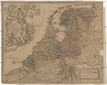
Belgica foederata complectens septem provincias, ducatum Geldriae, comitatus Hollandiae et Zeelandiae dioec. traject. transisul. Groningam et Frisiam et circumjacentes provincias mappa geographica
1 : 610000 Belgie Lotter, Tobias Conrad per Tobia[m] Conr. Lotter
Belgica foederata complectens septem provincias, ducatum Geldriae, comitatus Hollandiae et Zeelandiae dioec. traject. transisul. Groningam et Frisiam et circumjacentes provincias mappa geographica
1 : 610000 Belgie Lotter, Tobias Conrad Lotter, Matthäus Albrecht per Tobia[m] Conr. Lotter
Belgium foederatum
1 : 640000 Indonésie Seutter, Matthäus studio [Mattha]ei Seutteri
Belgium foederatum
1 Karte : Kupferdruck ; 47 x 55 cm Seutter Matthäus Seutter

Belgii Pars Septentrionalis communi nomine Vulgo Hollandia nuncupata
1 : 650000 Mollova mapová sbírka Homann, Johann Baptist Homann, Johann Baptista - dědici
Belgium Foederatum
1 : 620000 Mollova mapová sbírka Visscher, Nicolaes Schenk, Peter II
Foederatae Belgicae tabvla
1 : 728000 Limburg (Belgie) Wit, Frederick de F. de Wit
Karte der itzo vereinigten Niederlande
1 : 990000 Nizozemsko
Des Burgundischen Creisses Nordlicher Theil oder Vereinigte Niederlande
1 : 2200000 Mollova mapová sbírka Weigel, Christoph Weigel, Christoph I. - dědici
BELGICA | FOEDERATA
[Amsterdam : Joan Blaeu]
Belgii pars septentrionalis communi nomine vulgo Hollandia ...
1 : 640000 edente Petro Schenkio Amstelaedami : Petrus Schenkius
Nieuwe kaart der Vereenigde Nederlanden
1 : 900000 Amsterdam : by Isaak Tirion
Holland.
1 : 1048000 Hughes, William
Belgium Foederatum mendatè auctum et novissimè editum [Karte], in: Novus atlas absolutissimus, Bd. 3, S. 165.
1 Karte aus Atlas Janssonius Offizin
Seven United Provinces.
1 : 1460000 Bowen, Frances
Belgica Foederata
1 : 610000 Mollova mapová sbírka Lotter, Tobias Conrad Lotter, Tobias Conrad
Belgium Foederatum auctius et emendatius
1 : 780000 Mollova mapová sbírka Seutter, Matthäus Lotter, Tobias Conrad Seutter, Matthäus
Les Provinces Unies ou la Partie Septentrionale des Pays Bas
1 : 780000 Mollova mapová sbírka Coronelli, Vincenzo Maria Loon, Herman van Nolin, Jean Baptist François
Belgii pars septentrionalis communi nomine vulgo Hollandia ... = Land caerte van ’t Verenigde Nederland met ’t gene daer onderhoort, verdeelt in syn provincien en minder verdelingen
1 : 800000 naaukeurig aangewesen en uyt de beste aantekeninge opgestelt. Ultrajecti : Cornelius Kribber
Nieuwe algemeene kaart der Bataafsche Republiek : verdeeld in 94 districten bevattende ieder nagenoeg 20000 zielen
1 : 1400000 C. Covens delin. C. van Baarsel sculps. Te Amsterdam : bij Mortier Covens & Zoon
Provincie unite de Paesi Bassi
1 : 870000 descritte da Nicolo Sansone d'Abbeville ... e novamente intagliate da Gio. Batt.a Falda. Roma : Gio. Giacomo Rossi
Belgium foederatum
1 : 625000 Maastricht (Nizozemsko) Visscher, Nicolaes Jansz. Schenk, Pieter P. Schenk iunior
Belgium foederatum
1 : 625000 Maastricht (Nizozemsko) Visscher, Nicolaes Jansz. par Nicolaum Visscher
Belgium foederatum
1 : 630000 Belgie Visscher, Nicolaus per Nicolaum Visscher
A new and correct map of the seven provinces : drawn from the most approved maps and charts : the whole being regulated by astronomical observations
1 : 920000 by Eman Bowen. [London] : Tyndal
The United Provinces or Netherlands and Arx Britannica.
1 : 1450000 Moll, Herman, d. 1732
Descriptio veteris Agri Batavi et Frisi omnisque regionis quae hodie est in dicione VII. Foederatorvm cis et ultra Rhenvm
1 : 1100000 Mollova mapová sbírka Alting, Menso
Belgii Foederati Nova Descriptio. [Karte], in: Novus atlas absolutissimus, Bd. 3, S. 28.
1 Karte aus Atlas Janssonius Offizin