Maps of Netherlands

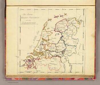
Seven United Provinces.
1 : 1460000 Bowen, Frances
Holland.
1 : 1290000 Finley, Anthony
Karte der itzo vereinigten Niederlande
1 : 990000 Nizozemsko
Holland.
1 : 1048000 Hughes, William
[Nizozemsko]
Nizozemsko Bilderdyk, W Veelwaard, D.
Nieuwe kaart der Vereenigde Nederlanden
1 : 900000 Amsterdam : by Isaak Tirion
Foederatae Belgicae tabvla
1 : 728000 Limburg (Belgie) Wit, Frederick de F. de Wit
Belgium foederatum
1 : 640000 Indonésie Seutter, Matthäus studio [Mattha]ei Seutteri
Belgica foederata complectens septem provincias, ducatum Geldriae, comitatus Hollandiae et Zeelandiae dioec. traject. transisul. Groningam et Frisiam et circumjacentes provincias mappa geographica
1 : 610000 Belgie Lotter, Tobias Conrad per Tobia[m] Conr. Lotter
Belgica foederata complectens septem provincias, ducatum Geldriae, comitatus Hollandiae et Zeelandiae dioec. traject. transisul. Groningam et Frisiam et circumjacentes provincias mappa geographica
1 : 610000 Belgie Lotter, Tobias Conrad Lotter, Matthäus Albrecht per Tobia[m] Conr. Lotter
Belgium foederatum / emendatius auctum et novissimé editum per Iustinum Danckerts Amstelodami
1 : 500000 Annotatie: Cum privil. Ordin. Holl. et Westfrisiae; Annotatie geografische gegevens: Met 2 schaalstokken Justus Danckertsz 1635-1701 [Amsterdam : Justus Danckerts]
Belgium foederatum
1 : 630000 1 Karte : Kupferdruck ; 49 x 55 cm Danckerts, Justus [Danckerts]
Belgica Foederata
1 : 610000 Mollova mapová sbírka Lotter, Tobias Conrad Lotter, Tobias Conrad
Comitatus Hollandiae denuo forma leonis
1 : 570000 Alkmaar (Nizozemnsko) Visscher, Claes Jansz. Nassau-Usingen, Karel van a Nicolao Iohannis Visscher

Des Burgundischen Creisses Nordlicher Theil oder Vereinigte Niederlande
1 : 2200000 Mollova mapová sbírka Weigel, Christoph Weigel, Christoph I. - dědici
Belgium Foederatum mendatè auctum et novissimè editum [Karte], in: Novus atlas absolutissimus, Bd. 3, S. 165.
1 Karte aus Atlas Janssonius Offizin
Belgium foederatum
1 Karte : Kupferdruck ; 47 x 55 cm Seutter Matthäus Seutter
Bladwijzer van de kaarten op de schaal van 1:25 000, 1:50 000 en 1:200 000
1 : 600000 Nizozemsko Topogr. Inrichting
Proef eener geologische kaart van de Nederlanden
1 : 800000 door W.C.H. Staring op steen geteekend en gegraveerd door J.Jaeger. Groningen : J. Oomkens Jz
[25]. Nederland : de dijken weggedacht ..., uit: Geologische kaart van Nederland : schaal van 1:200.000 / door W.C.H. Staring ; uitgevoerd door het Topographisch Bureau van Oorlog ; uitgegeven op last van Zijne Majesteit Den Koning
Annotatie: Impressum ontleend aan omslag; Kaart "Nederland de dijken weggedacht" [kaart 25] en kaart 13 (bladwijzer) vermelden het jaar 1869; Kaart 'Limburg en de Hesbaije' (bladnr. 26) vermeldt het jaar 1868; Blad 5/9 ontbreekt Topographische Inrichting, 's-Gravenhage; Topographisch Bureau Haarlem : A.C. Kruseman
Seven United Provinces.
1 : 950000 Playfair, Principal
Pays-Bas.
1 : 700000 Vivien St Martin, L.
Nouvelle carte de la Hollande, d'apres Krayenhoff et les meilleurs cartes connues : 24 feuilles
1 : 115200 Établissement Géographique de Bruxelles, Fondé par Ph. Vander Maelen. Bruxelles : Etablissement geographique, fondé par Ph. Vander Maelen
Netherlands.
1 : 1290000 Hughes, William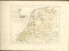

Belgii Pars Septentrionalis communi nomine Vulgo Hollandia nuncupata
1 : 650000 Mollova mapová sbírka Homann, Johann Baptist Homann, Johann Baptista - dědici
Belgium Foederatum
1 : 620000 Mollova mapová sbírka Visscher, Nicolaes Schenk, Peter II
Holland.
1 : 1300000 Darton, William