Maps of West Indies
Archipelague du Mexique ou sont les Isles de Cuba, Espagnole, Jamaïque &c.
1 : 5000000 [par Pierre Mortier]
A NEW MAPP of the WEST INDIES, or the ISLANDS of AMERICA in the NORTH SEA; Together with the adjacent DOMINIONS; Explaining what belongs to SPAIN, ENGLAND, FRANCE, HOLLAND &C. As also the severall Tracts made by the Gallions and Flota from place to place,
This interesting map published in 1740 is a later edition of one published by Robert Morden, William Knight and Philip Lea. The colonising powers are indicated in words but colouring is mainly for decoration. Notes give an idea of shipping routes and practices, and in the Gulf of Mexico the number of fathoms in depth are said to be equal to the distance in leagues from the coast! The sketch at bottom left which forms part of the title cartouche shows a group of sailors presenting a pair of shoes to a native in exchange for a chest of gold coins. Morden, Robert. Cartographer.
Archipelague du Mexique ou sont les Isles de Cuba, Espagnole, Jamaïque &c.
1 : 5000000 [par Pierre Mortier] A Amsterdam : nouvellement mis au jour par Covens & Mortier
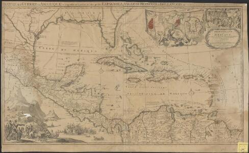
Teatre de la guerre en Amerique telle que'elle est a present possedee par les Espagnols, Anglois, Francois, et Hollandois &c. : nouvellement mis au jour
1 : 5533975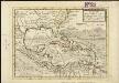
A map of the West-Indies &c. Mexico or New Spain, also ye trade winds, and ye several tracts made by ye galeons and flota from place to place
1 : 18000000
Mappa Geographica, complectens I. Indiae Occidentalis Partem Mediam Circum Isthmum Panamensem II. Ipsumq[ue] Isthmum III. Ichnographiam praecipuorum locorum & portuum ad has terras pertinentium

Insulae Americanae In Oceano Septentrionali, cum Terris Adiacentibus. [Karte], in: Le théâtre du monde, ou, Nouvel atlas contenant les chartes et descriptions de tous les païs de la terre, Bd. 2, S. 308.
1 Karte aus Atlas Blaeu, Willem Janszoon und Blaeu, Joan Blaeu, Willem Janszoon
A map of the West-Indies &c. with the adjacent countries: also ye trade winds, and ye several tracts made by ye galeons and flota from place to place / by H. Moll, g., 1727.; A set of thirty-two new and correct maps of the principal parts of Europe, &c.: with the great or post-roads, and principal cross-roads, done in the year 1725, 1726 and 1727: all except four, viz. England, Scotland, Ireland, and a general map of Turky in Europe, which have been done and printed before ... / all done according to the latest observations, by Herman Moll, geographer.
from A set of thirty-two new and correct maps of the principal parts of Europe, &c. : with the great or post-roads, and principal cross-roads, done in the year 1725, 1726 and 1727 : all except four, viz. England, Scotland, Ireland, and a general map of Turky in Europe, which have been done and printed before ... / all done according to the latest observations, by Herman Moll, geographer. Moll, Herman,
Insulae Americanae In Oceano Septentrionali, cum Terris adiacentibus. [Karte], in: Theatrum orbis terrarum, sive, Atlas novus, Bd. 2, S. 312.
1 Karte aus Atlas Blaeu, Joan Blaeu, Willem Janszoon
Insulae Americanae In Oceano Septentrionali, cum Terris adiacentibus. [Karte], in: Novus atlas absolutissimus, Bd. 6, S. 219.
1 Karte aus Atlas Janssonius Offizin
Mittel-America und Westindien
Neuer Handatlas über alle Theile der Erde Kiepert, Heinrich Verlag von Dietrich Reimer
Iles-Antilles ou Indes Occidentales.
1 : 9300000 Brue, Adrien Hubert, 1786-1832
Insulae Americanae In Oceano Septentrionali, cum Terris adiacentibus. [Karte], in: Gerardi Mercatoris et I. Hondii Newer Atlas, oder, Grosses Weltbuch, Bd. 2, S. 379.
1 Karte aus Atlas Mercator, Gerhard und Hondius, Jodocus Jansson, Jan
Carte Particuliere des Antilles du Golfe du Mexique avec l'Isthme de Panama.
1 : 12700000 Vivien de St Martin, L.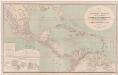
A new map of tropical-America, north of the Equator : comprising the West-Indies, Central-America, Mexico, New Cranada [sic] and Venezuela
1 : 3600000 Kiepert, Heinrich, 1818-1899 Dietrich Reimer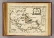
Golfe du Mexique, Isles Antilles.
1 : 19500000 Delamarche, Charles Francois
[144][147] Indiarum Occidentalium Tractus Littorales cum Insulis Caribicis ..., uit: Atlas sive Descriptio terrarum orbis
Annotatie: Gedigitaliseerde versie. Amsterdam. Heiloo : Picturae (vervaardiger), 2015. tiff-bestand. Gedigitaliseerd: 07-01-2015; Origineel: Universiteitsbibliotheek Vrije Universiteit (XL.05127.-) ; Netherlands; Titelpagina ontbreekt Wit, Frederik de Amsterdam : Frederick de Wit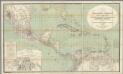
H. Kiepert's Karte des nordlichen Tropischen America.
1 : 3600000 Smith, Martin Luther, 1819-1866
Texas, der Mexicanische Bundesstaat, der Mittelamericanische Bundesstaat, und West Indien
Schul-Atlas in 36 Karten Völter, Daniel Verlag der J.M. Dannheimer'schen Buchhandlung
The West Indies and coast adjacent, reduced from the sheet map
1 : 16663680
INSULAE AMERICANAE in Oceano Septentrionalis ac REGIONES ADIACENTES
1 : 10300000 Karibská oblast Visscher, Nicolaes Jansz. per Nicolaum Visscher
Chart of the West Indies.
1 : 11750000 Carey, Mathew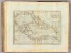
Chart of the West Indies.
1 : 11750000 Carey, Mathew
Chart of the West Indies.
1 : 11000000 Carey, Mathew
Chart of the West Indies.
1 : 11750000 Carey, Mathew
Chart Of The West Indies And Spanish Dominions In North America.
1 : 2700000 Arrowsmith, Aaron
West India Islands.
1 : 14500000 Darton, William
INSVLÆ AMERICANÆ | IN OCEANO SEPTENTRIONALI, | cum Terris adiacentibus
[Amsterdam : Joan Blaeu]
Map of the West-Indies, Mexico or New Spain.
1 : 21000000 Moll, Herman, d. 1732