Maps of West Indies
Golfe du Mexique, Isles Antilles.
1 : 19500000 Delamarche, Charles Francois
Westindien
Atlas der Hydrographie Berghaus, Hermann Justus Perthes
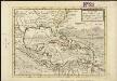
A NEW MAPP of the WEST INDIES, or the ISLANDS of AMERICA in the NORTH SEA; Together with the adjacent DOMINIONS; Explaining what belongs to SPAIN, ENGLAND, FRANCE, HOLLAND &C. As also the severall Tracts made by the Gallions and Flota from place to place,
This interesting map published in 1740 is a later edition of one published by Robert Morden, William Knight and Philip Lea. The colonising powers are indicated in words but colouring is mainly for decoration. Notes give an idea of shipping routes and practices, and in the Gulf of Mexico the number of fathoms in depth are said to be equal to the distance in leagues from the coast! The sketch at bottom left which forms part of the title cartouche shows a group of sailors presenting a pair of shoes to a native in exchange for a chest of gold coins. Morden, Robert. Cartographer.
[West-Indien und Centro-America, nebst dem Meerbusen von Mexico]
Schul-Atlas über alle Theile der Erde nach dem neuesten Zustande, und über das Weltgebäude Stieler, Adolf bei Justus Perthes
Mappa geographica Americae Septentrionalis : ad emendatiora exemplaria adhuc edita jussu Acad. reg. scient. et eleg. litt. descripta.
from Charts and maps
Archipelague du Mexique ou sont les Isles de Cuba, Espagnole, Jamaïque &c.
1 : 5000000 [par Pierre Mortier]
Insulae Americanae in Oceano Septentrionali ac regiones adjacentes a C. de May usque ad Lineam Aequinoctialem
1 : 10000000 per Nicolaum Visscher [Amsterdam] : nunc apud Petrum Schenk Junior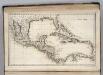
West Indies.
1 : 12500000 Carey, Mathew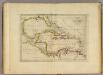
Chart of the West Indies.
1 : 11750000 Carey, Mathew
[West-Indien und Centro-America, nebst dem Meerbusen von Mexico]
Schul-Atlas über alle Theile der Erde nach dem neuesten Zustande, und über das Weltgebäude Stieler, Adolf Justus Perthes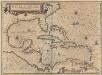
Insulae Americanae In Oceano Septentrionali, cum Terris adiacentibus. [Karte], in: Novus atlas absolutissimus, Bd. 6, S. 219.
1 Karte aus Atlas Janssonius Offizin
Insulae Americanae in Oceano Septentrionali ac REGIONES ADIACENTES, a C. de May usque ad Lineam Aequinoctialem
This early 18th century map of the West Indies was produced by Nicolaes Visscher II who was the grandson of celebrated Dutch map maker Claes Jansz Visscher. It was originally published in c.1690 in his Atlas Minor but this is a reprint of c.1717 by Pieter Schenk. It is a typical elaborately decorated Dutch map and the colouring of the islands is decorative as opposed to functional. Visscher, Nicholaum. Cartographer.
Texas, der Mexicanische Bundesstaat, der Mittelamericanische Bundesstaat, und West Indien
Schul-Atlas in 36 Karten Völter, Daniel Verlag der J.M. Dannheimer'schen Buchhandlung
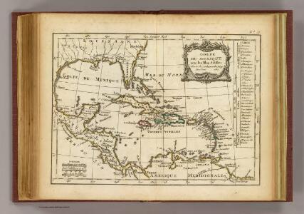
Carte du Golfe du Mexique et des Isles Antilles
1 : 10168000
Insulae Americanae in Oceano Septentrionali ac regiones adiacentes, a C. de May usque ad Lineam Aequinoctialem
1 : 9936000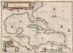
Insulae Americanae In Oceano Septentrionali, cum Terris adiacentibus. [Karte], in: Theatrum orbis terrarum, sive, Atlas novus, Bd. 2, S. 312.
1 Karte aus Atlas Blaeu, Joan Blaeu, Willem Janszoon
Insulae Americanae In Oceano Septentrionali, cum Terris Adiacentibus. [Karte], in: Le théâtre du monde, ou, Nouvel atlas contenant les chartes et descriptions de tous les païs de la terre, Bd. 2, S. 308.
1 Karte aus Atlas Blaeu, Willem Janszoon und Blaeu, Joan Blaeu, Willem Janszoon
Mappa Geographica, complectens I. Indiae Occidentalis Partem Mediam Circum Isthmum Panamensem II. Ipsumq[ue] Isthmum III. Ichnographiam praecipuorum locorum & portuum ad has terras pertinentium
A map of the West-Indies &c. Mexico or New Spain, also ye trade winds, and ye several tracts made by ye galeons and flota from place to place
1 : 18000000
INSULAE AMERICANAE in Oceano Septentrionalis ac REGIONES ADIACENTES
1 : 10300000 Karibská oblast Visscher, Nicolaes Jansz. per Nicolaum Visscher
Mittel-America und Westindien
Neuer Handatlas über alle Theile der Erde Kiepert, Heinrich Verlag von Dietrich Reimer
215-216. Central America and West Indies. The World Atlas.
1 : 7500000 USSR (Union of Soviet Socialist Republics).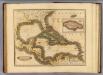
West India Islands.
1 : 13400000 Lizars, Daniel
Archipelague du Mexique ou sont les Isles de Cuba, Espagnole, Jamaïque &c.
1 : 5000000 [par Pierre Mortier] A Amsterdam : nouvellement mis au jour par Covens & Mortier
Insulae Americanae in Oceano Septentrionali ac Regiones Adiacentes, a. C. de May usque ad Lineam Aequinoctialem. [Karte], in: Novus atlas absolutissimus, Bd. 9, S. 68.
1 Karte aus Atlas Janssonius Offizin
Insulae Americanae In Oceano Septentrionali, cum Terris adiacentibus. [Karte], in: Gerardi Mercatoris et I. Hondii Newer Atlas, oder, Grosses Weltbuch, Bd. 2, S. 379.
1 Karte aus Atlas Mercator, Gerhard und Hondius, Jodocus Jansson, Jan
A map of the West-Indies &c. with the adjacent countries: also ye trade winds, and ye several tracts made by ye galeons and flota from place to place / by H. Moll, g., 1727.; A set of thirty-two new and correct maps of the principal parts of Europe, &c.: with the great or post-roads, and principal cross-roads, done in the year 1725, 1726 and 1727: all except four, viz. England, Scotland, Ireland, and a general map of Turky in Europe, which have been done and printed before ... / all done according to the latest observations, by Herman Moll, geographer.
from A set of thirty-two new and correct maps of the principal parts of Europe, &c. : with the great or post-roads, and principal cross-roads, done in the year 1725, 1726 and 1727 : all except four, viz. England, Scotland, Ireland, and a general map of Turky in Europe, which have been done and printed before ... / all done according to the latest observations, by Herman Moll, geographer. Moll, Herman,
INSVLÆ AMERICANÆ | IN OCEANO SEPTENTRIONALI, | cum Terris adiacentibus
[Amsterdam : Joan Blaeu]
West Indies.
1 : 7900000 Thomson, John