Maps of West Indies
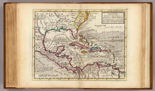
Map of the West-Indies, Mexico or New Spain.
1 : 21000000 Moll, Herman, d. 1732
West Indies.
1 : 12500000 Bowen, Emanuel

Regni Mexicani seu Novae Hispaniae, Ludovicianae, N. Angliae, Carolinae, Virginiae, Pensylvaniae, ... in America Septentrionali
from John H. Levine Collection
Carte générale de l'Amérique séptentrionale: avec les posséssions Angloises dans cette partie du nouveau monde / dressée sur la carte de Pople [sic], publiée à Londres en 20 feuilles, pour servir à l'intelligence de la guerre présente.
from Whole Henry Popple,
A map of the West-Indies &c. with the adjacent countries: also ye trade winds, and ye several tracts made by ye galeons and flota from place to place / by H. Moll, g., 1727.; A set of thirty-two new and correct maps of the principal parts of Europe, &c.: with the great or post-roads, and principal cross-roads, done in the year 1725, 1726 and 1727: all except four, viz. England, Scotland, Ireland, and a general map of Turky in Europe, which have been done and printed before ... / all done according to the latest observations, by Herman Moll, geographer.
from A set of thirty-two new and correct maps of the principal parts of Europe, &c. : with the great or post-roads, and principal cross-roads, done in the year 1725, 1726 and 1727 : all except four, viz. England, Scotland, Ireland, and a general map of Turky in Europe, which have been done and printed before ... / all done according to the latest observations, by Herman Moll, geographer. Moll, Herman,
Composite: North America.
1 : 5400000 Jefferys, Thomas
Amerikanisch-spanischer Kriegsschauplatz
1 : 7500000 Habenicht, Hermann Justus Perthes
Map of the United States of America, the British provinces, Mexico, the West Indies and Central America, with part of New Granada and Venezuela / map drawn by Geo. W. Colton; engraved by John M. Atwood; border desig'd. & eng'd. by W.S. Barnard.
from Parts George W. Colton; John M. Atwood; W. S. Barnard,
Carte du Méxique, des Antilles, d'une partie des Etats-Unis, et des pays circonvoisins
1 : 8333000 dressée d'après les nouvelles divisions, et les dernières observations par A. H. Dufour [gravée par] Guyot ; [écrite par] A. Pelicier Paris : Guyot [etc.]
A new map of North America with the West India Islands: divided according to the preliminary articles of peace, signed at Versailles, 20, Jan. 1783; wherein are particularly distinguished the United States and the several provinces, governments & ca. which compose the British dominions / laid down according to the latest surveys and corrected from the original materials of Goverr. Pownall, Membr. of Parliamt., 1783.
from Charts and maps Governor Pownall,
Composite: North America.
1 : 5400000 Robert Laurie & James Whittle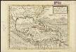
A map of the West-Indies &c. Mexico or New Spain, also ye trade winds, and ye several tracts made by ye galeons and flota from place to place
1 : 18000000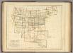
Index Map. Explanation of Signs Used In The Atlas.
1 : 17233920 Rogers, Henry Darwin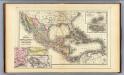
Mexico, Central America, West Indies.
1 : 12000000 Mitchell, Samuel Augustus
Cuba.
1 : 3300000 Mitchell, Samuel Augustus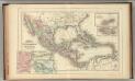
Mexico, Central America, West Indies.
1 : 12000000 Mitchell, Samuel Augustus Jr.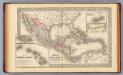
Mexico, Central America, West Indies.
1 : 12000000 Mitchell, Samuel Augustus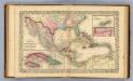
Mexico, Central America, West Indies.
1 : 12000000 Williams, W. (Wellington)
Mappa geographica regionem Mexicanam et Floridam terrasque adjacentes, ut et anteriores Americae insulas, cursus itidem et reditus navigantium versus flumen Missisipi et alias colonias ob oculos ponens
1 : 9300000 cura et sumptibus Tobiae Conradi Lotteri, Geographi Et Chalcographi Tob. Con. Lotter sculps. Augustae Vindel : [Tobias Conrad Lotter]
Insulae Americanae in Oceano Septentrionali ac regiones adiacentes, a C. de May usque ad Lineam Aequinoctialem
1 : 9936000
[144][147] Indiarum Occidentalium Tractus Littorales cum Insulis Caribicis ..., uit: Atlas sive Descriptio terrarum orbis
Annotatie: Gedigitaliseerde versie. Amsterdam. Heiloo : Picturae (vervaardiger), 2015. tiff-bestand. Gedigitaliseerd: 07-01-2015; Origineel: Universiteitsbibliotheek Vrije Universiteit (XL.05127.-) ; Netherlands; Titelpagina ontbreekt Wit, Frederik de Amsterdam : Frederick de Wit
Insulae Americanae in Oceano Septentrionali ac REGIONES ADIACENTES, a C. de May usque ad Lineam Aequinoctialem
This early 18th century map of the West Indies was produced by Nicolaes Visscher II who was the grandson of celebrated Dutch map maker Claes Jansz Visscher. It was originally published in c.1690 in his Atlas Minor but this is a reprint of c.1717 by Pieter Schenk. It is a typical elaborately decorated Dutch map and the colouring of the islands is decorative as opposed to functional. Visscher, Nicholaum. Cartographer.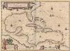
Insulae Americanae In Oceano Septentrionali, cum Terris adiacentibus. [Karte], in: Novus Atlas, das ist, Weltbeschreibung, Bd. 2, S. 311.
1 Karte aus Atlas Blaeu, Joan Blaeu, Willem Janszoon
Carte du Mexique et de la Floride des Terres Angloises et des Isles Antilles du cours et des environs de la riviere de Mississipi
1 : 9000000 dressée sur un grand nombre de memoires principalement sur ceux de Mrs. d'Iberville et le Sueur par Guillaume De l'Isle geographe de l'Academie Royale des Sciences I. Stemmers Senior sculp. A Amsterdam : chez Jean Covens & Corneille Mortier
A map of the British Empire in America: with the French, Spanish and Hollandish settlements adjacent thereto / by Henry Popple; I. Condet s.
from John H. Levine Collection Henry Popple; I. Condet s.,
Amerique septentrionale: suivant la carte de Pople faite à Londres en 20 feuilles.
from Charts and maps Par et chez le Sr. le Rouge ...: Paris; Lawson, Oscar A.; Le Rouge, Georges-Louis,
America Septentrionalis A Map of the British Empire in America.
1 : 11000000 Popple, Henry
Composite: British Empire in America.
1 : 2000000 Popple, Henry