Maps of Millstone Township

Roosevelt
1 : 24000
Roosevelt
1 : 24000
Roosevelt
1 : 24000
Roosevelt
1 : 24000
Roosevelt
1 : 24000
Roosevelt
1 : 24000
Lakehurst
1 : 62500
Lakehurst
1 : 62500
Cassville
1 : 62500
Cassville
1 : 62500
Cassville
1 : 62500
Cassville
1 : 62500
Cassville
1 : 62500
8 Trenton.
1 : 63360 Vermeule, C. C. (Cornelius Clarkson), 1858-1950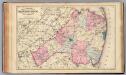
Monmouth Co., N.J.
1 : 126720 Beers, F. W. (Frederick W.)
Navesink
1 : 125000
Navesink
1 : 125000
Navesink
1 : 125000
Upper Freehold [Township]
from Atlas of Monmouth co., New Jersey. From recent and actual surveys and records, under the superintendence of F.W. Beers.
Camp Dix
1 : 62500
Freehold [Township]; Freehold Business Notices.
from Atlas of Monmouth co., New Jersey. From recent and actual surveys and records, under the superintendence of F.W. Beers.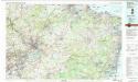
Trenton
1 : 100000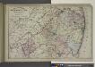
Topographical Map of Monmouth Co., New Jersey.
from Atlas of Monmouth co., New Jersey. From recent and actual surveys and records, under the superintendence of F.W. Beers.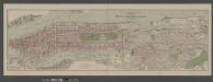
Boroughs of Manhattan and Bronx, showing the electric service of the New York Edison Co.
From Manhattan
General map of the city of New York, consisting of boroughs of Manhattan, Brooklyn, Bronx, Queens and Richmond : consolidated into one municipality by act of the legislature of the state of New York (Chapter 378 of the laws of 1897) : showing in addit...
From Whole
Map of Long Island with the environs of New-York and the southern part of Connecticut / compiled from various surveys & documents by J. Calvin Smith ; engraved & printed by S. Stiles & Co., N. York.
From Long Island
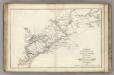
A plan of the northern part of New Jersey : shewing the positions of the American and British armies after crossing the North River in 1776 / drawn by S. Lewis from surveys by order of Gen. Washington ; engrav'd by Fs. Shallus.
from Revolutionary War, 1775-1783
[Map of the vicinity of City Hall, Brooklyn.]
From Brooklyn
A New and accurate map of the present seat of war in North America, comprehending New Jersey, Philadelphia, Pensylvania, New-York, &c.
1 : 550000