Maps of Monmouth County

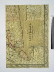
Map of Long Island with the environs of New-York and the southern part of Connecticut / compiled from various surveys & documents by J. Calvin Smith ; engraved & printed by S. Stiles & Co., N. York.
From Long Island
Map of the counties of New York, Queens, Kings, and Richmond.
from An atlas of the state of New York : containing a map of the state and of the several counties. / Projected and drawn under the superintendence and direction of Simeon de Witt ... And also the physical geography of the State ...
The country twenty five miles round New York
1 : 220000 ... W. Hawkes (successor to T. Kitchin), No. 59, Holborn Hill
Thirty miles round the city of New York
from Whole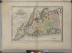
Map of the counties of New York, Queens, Kings, and Richmond.
from An atlas of the state of New York, designed for the use of engineers, containing a map of the state and of the several counties. / Projected and drawn ... under the superintendence and direction of Simeon de Witt.
Map of the counties of New York, Queens, Kings, and Richmond.
from An atlas of the state of New York : containing a map of the state and of the several counties / by David H. Burr.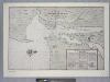
Vingboons map of Manhattan, 1639 : a facsimile from the Library of Congress.
from Whole
Map of the progress of His Majesty's armies in New York during the late campaign : illustrating the accounts publish'd in the London Gazette.
from Revolutionary War
40 miles around New York
1 : 158400 H.H. Lloyd & Co
Map of the country thirty miles round the city of New York
1 : 190080 Disturnell, John, 1801-1877 J. Disturnell
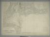
Map of Long Island with the environs of New-York and the southern part of Connecticut / compiled from various surveys & documents by J. Calvin Smith ; engraved & printed by S. Stiles & Co., N. York.
From Long Island
Thirty miles round the city of New York
from Whole
General map of the city of New York, consisting of boroughs of Manhattan, Brooklyn, Bronx, Queens and Richmond : consolidated into one municipality by act of the legislature of the state of New York (Chapter 378 of the laws of 1897) : showing in addit...
From Whole
Map Of The Country Thirty Miles Round the City of New York.
1 : 190080 Eddy, John H.
Map ... Around The City Of New York.
1 : 205920 Colton, J. H.
Chief Engineer's Office. Board of Estimate and Apportionment. Index Map. Showing Location of the Sectional Plans of the City of New York.
from Height district map / City of New York, Board of Estimate and Apportionment.
A draught of New York and Perthamboy Harbour.
from Charts and maps
Map of New-York and its vicinity /drawn by D.H. Burr, geographer ; engraved by S. Stiles, Sherman & Smith.
from New York harbor
United States--east coast, New York--New Jersey, New York Harbor / Coast Survey.
from New York harbor
New York and vicinity [map]
1 : 24000 Geological Survey (U.S.) Geological Survey
Map of New-York Bay and Harbor and the environs / founded upon a trigonometrical survey under the direction of F.R. Hassler, superintendent of the Survey of the Coast of the United States ; triangulation by James Ferguson and Edmund Blunt, assistants ; t
from New York harbor
Map of the Country Twenty Five Miles Round The City Of New-York.
1 : 300000 Greenleaf, Jeremiah
Map of the Country Twenty Five Miles Round The City Of New-York.
1 : 316800 Greenleaf, Jeremiah
Hammond's complete map of Brooklyn.
From Brooklyn
Watson's guide map to summer resorts around New York.
from Whole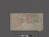
Map of New York City showing portions of Brooklyn, Jersey City, and Westchester Co.
From Manhattan
Map of the Country Twenty Five Miles Round The City Of New-York.
1 : 211200 Burr, David H., 1803-1875
Nature's estuary: the historic tidelands of the New York New Jersey harbor estuary / cartographic design by Jennifer Cox; cartographers George Colbert and Guenter Vollath.
Jennifer Cox; George Colbert; Guenter Vollath,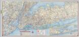
Shell Metropolitan New York and Long Island. Eastern Long Island.
1 : 126720 Shell Oil Company