Maps of Monmouth County
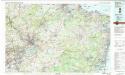
Trenton
1 : 100000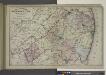
Topographical Map of Monmouth Co., New Jersey.
from Atlas of Monmouth co., New Jersey. From recent and actual surveys and records, under the superintendence of F.W. Beers.
Trenton
1 : 125000
Trenton
1 : 125000
Trenton
1 : 125000
Navesink
1 : 125000
Navesink
1 : 125000
Navesink
1 : 125000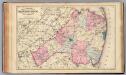
Monmouth Co., N.J.
1 : 126720 Beers, F. W. (Frederick W.)
Plan of the operations of General Washington against the Kings troops in New Jersey : from the 26th of December, 1776, to the 3d January, 1777 / by William Faden.
from Cartographic materials from the Emmet Collection of Manuscripts Etc. Relating to American History.
Hammods Atlas of New York City and the metropolitan district

8 Trenton.
1 : 63360 Vermeule, C. C. (Cornelius Clarkson), 1858-1950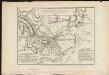
Plan of the operations of General Washington, against the Kings troops in New Jersey : from the 26th. of December 1776, to the 3d. January 1777
1 : 113000 Faden, William Faden, William
Mercer Co., N.J.
1 : 126720 Beers, F. W. (Frederick W.)
9 Monmouth shore.
1 : 63360 Vermeule, C. C. (Cornelius Clarkson), 1858-1950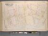
Monmouth County, Double Page Plate No. 6 [Map of Rumson Rd., and Adjaining Properties]
From Wolverton's atlas of Monmouth County, New Jersey : compiled from actual surveys, state and county official records and private plans.
Bordentown
1 : 62500
Bordentown
1 : 62500
Lakehurst
1 : 62500
Lakehurst
1 : 62500
Bordentown
1 : 62500
Bordentown
1 : 62500
Bordentown
1 : 62500
Bordentown
1 : 62500
Bordentown
1 : 62500
Bordentown
1 : 62500
Asbury Park
1 : 62500
Asbury Park
1 : 62500
Asbury Park
1 : 62500
Asbury Park
1 : 62500
Asbury Park
1 : 62500
Cassville
1 : 62500
Cassville
1 : 62500
Cassville
1 : 62500
Cassville
1 : 62500
Bordentown
1 : 62500
Bordentown
1 : 62500
Bordentown
1 : 62500
Asbury Park
1 : 62500
Asbury Park
1 : 62500
Bordentown
1 : 62500
Cassville
1 : 62500

