Maps of Bayeux
Capitaineries garde costes de Grais Port S.te Honorine Grand Camp Carentan et de la Hougue
1 Karte : 22 x 33 cm de Fer
France 1:50,000 , Series GSGS 4250, Isigny
France 1:50,000 , Series GSGS 4250. Great Britain. War Office. General Staff. Geographical Section. [London] : Ordnance Survey
France 1:50,000 , Series GSGS 4250, Creully
France 1:50,000 , Series GSGS 4250. Great Britain. War Office. General Staff. Geographical Section. [London] : Ordnance Survey
93 La Hougue.
1 : 86400 Cassini family; Cassini, Cesar-Francois, 1714-1784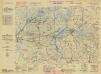
France, 1:25,000, GSGS 4347 [Defence O/P], Isigny
France, 1:25,000, GSGS 4347 [Defence O/P]. Defence overprinted in blue, red and purple on GSGS 4347. -- Mixture of 'Bigot' and non-'Bigot' sheets. Most sheets marked 'Defences'. -- Includes various editions. -- Sheets show German defences in Normandy. Great Britain. War Office. [London] : War Office
France 1:25,000, Ryes
France 1:25,000 , Series GSGS 4347. Great Britain. War Office. [S.l.] : [s.n.]
France 1:25,000, Isigny
France 1:25,000 , Series GSGS 4347. Great Britain. War Office. [S.l.] : [s.n.]
France 1:25,000, Creully
France 1:25,000 , Series GSGS 4347. Great Britain. War Office. [S.l.] : [s.n.]
Isigny [Town plan] (1944)
Town plan Isigny, US Misc 91. United States. Army. Engineer Topographical Battalion, 654th. [S.l.] : [s.n.]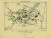
Caretan, France 1:2,500 (1944)
France. Carentan. Scale 1 : 2,500. [G.S.G.S. No. 4234]
France 1:25,000, Thaon
France 1:25,000 , Series GSGS 4347. Great Britain. War Office. [S.l.] : [s.n.]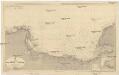
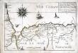
Der Kanal
1 : 150000 Francie Reichs-Marine-Amt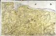
[Bayeux - Caen]
1 Blatt : 60 x 92 cm s.n.
Carte topographique du diocese de Bayeux, 1
1 Blatt : Jaillot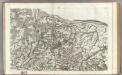
94 Bayeux, Caen.
1 : 86400 Cassini family; Cassini, Cesar-Francois, 1714-1784
[La Hougue]
1 Blatt : 60 x 47 cm Seguin; Le Roy s.n.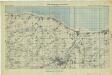
Arromanches - Carourg (Special), 21A Gp No 2
Arromanches - Carourg (Special), 21A Gp No 2. [S.l.] : [21st Army Group, United Kingdom]
France 1:50,000 , Series GSGS 4250, St. Lo
France 1:50,000 , Series GSGS 4250. Great Britain. War Office. General Staff. Geographical Section. [London] : Ordnance Survey
France 1 : 50,000 [GSGS 4250 AMS M762], Caen
Sheet 7F-1 from the map series: France 1 : 50,000. [G.S.G.S. 4250. A.M.S. M762] [London] : War Office
France, 1:25,000, GSGS 4347 [Defence O/P], Carentan
France, 1:25,000, GSGS 4347 [Defence O/P]. Defence overprinted in blue, red and purple on GSGS 4347. -- Mixture of 'Bigot' and non-'Bigot' sheets. Most sheets marked 'Defences'. -- Includes various editions. -- Sheets show German defences in Normandy. Great Britain. War Office. [London] : War Office
France 1:25,000, Carentan
France 1:25,000 , Series GSGS 4347. Great Britain. War Office. [S.l.] : [s.n.]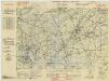
France, 1:25,000, GSGS 4347 [Defence O/P], Ste Mere Eglise
France, 1:25,000, GSGS 4347 [Defence O/P]. Defence overprinted in blue, red and purple on GSGS 4347. -- Mixture of 'Bigot' and non-'Bigot' sheets. Most sheets marked 'Defences'. -- Includes various editions. -- Sheets show German defences in Normandy. Great Britain. War Office. [London] : War Office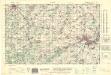
France 1:50,000 , Series GSGS 4250, Caen
France 1:50,000 , Series GSGS 4250. Great Britain. War Office. General Staff. Geographical Section. [London] : Ordnance Survey
Carte de la province de Normandie, 1
1 Blatt : Esnauts et Rapilly
Le gouvernement general de Normandie, 1
1 Blatt : chez l'auteur Jaillot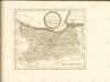

Northwestern Normandy : natural regions
1 : 550000 Provisional ed. Relief shown by shading. "Map no. 2369, 8 July 1943." "Restricted." "Reliability code: 00--2B--2." United States. Office of Strategic Services. Research and Analysis Branch [Washington, D.C.] : R & A, OSS
De Fransche Kanaalkust : (Cherbourg-Le Tréport)
1 : 1000000 Den Haag : Kompas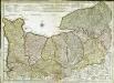
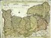
Carte de Normandie
1 Karte : Kupferdruck ; 47 x 65 cm L'Isle; Buache; Dezauche chez Dezauche graveur successeur et possesseur du fond géographique des S.rs Delisle et Buache et chargés de l'entrepo't général des cartes de la marine rue des Noyers