Maps of Saint-Lô

Carte topographique du diocese de Bayeux, 1
1 Blatt : Jaillot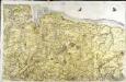
[Bayeux - Caen]
1 Blatt : 60 x 92 cm s.n.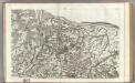
94 Bayeux, Caen.
1 : 86400 Cassini family; Cassini, Cesar-Francois, 1714-1784
France 1:50,000 , Series GSGS 4250, St. Lo
France 1:50,000 , Series GSGS 4250. Great Britain. War Office. General Staff. Geographical Section. [London] : Ordnance Survey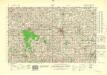
France 1:50,000 , Series GSGS 4250, Vire
France 1:50,000 , Series GSGS 4250. Great Britain. War Office. General Staff. Geographical Section. [London] : Ordnance Survey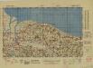
France 1:50,000 , Series GSGS 4250, Isigny
France 1:50,000 , Series GSGS 4250. Great Britain. War Office. General Staff. Geographical Section. [London] : Ordnance Survey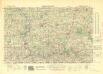
France 1:50,000 , Series GSGS 4250, Torigni-sur-Vire
France 1:50,000 , Series GSGS 4250. Great Britain. War Office. General Staff. Geographical Section. [London] : Ordnance Survey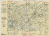
France, 1:25,000, GSGS 4347 [Defence O/P], Ste Mere Eglise
France, 1:25,000, GSGS 4347 [Defence O/P]. Defence overprinted in blue, red and purple on GSGS 4347. -- Mixture of 'Bigot' and non-'Bigot' sheets. Most sheets marked 'Defences'. -- Includes various editions. -- Sheets show German defences in Normandy. Great Britain. War Office. [London] : War Office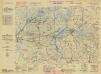
France, 1:25,000, GSGS 4347 [Defence O/P], Isigny
France, 1:25,000, GSGS 4347 [Defence O/P]. Defence overprinted in blue, red and purple on GSGS 4347. -- Mixture of 'Bigot' and non-'Bigot' sheets. Most sheets marked 'Defences'. -- Includes various editions. -- Sheets show German defences in Normandy. Great Britain. War Office. [London] : War Office
France, 1:25,000, GSGS 4347 [Defence O/P], Carentan
France, 1:25,000, GSGS 4347 [Defence O/P]. Defence overprinted in blue, red and purple on GSGS 4347. -- Mixture of 'Bigot' and non-'Bigot' sheets. Most sheets marked 'Defences'. -- Includes various editions. -- Sheets show German defences in Normandy. Great Britain. War Office. [London] : War Office
France 1:25,000, Carentan
France 1:25,000 , Series GSGS 4347. Great Britain. War Office. [S.l.] : [s.n.]
France 1:25,000, Ryes
France 1:25,000 , Series GSGS 4347. Great Britain. War Office. [S.l.] : [s.n.]
France 1:25,000, Isigny
France 1:25,000 , Series GSGS 4347. Great Britain. War Office. [S.l.] : [s.n.]
Isigny [Town plan] (1944)
Town plan Isigny, US Misc 91. United States. Army. Engineer Topographical Battalion, 654th. [S.l.] : [s.n.]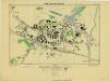
Caretan, France 1:2,500 (1944)
France. Carentan. Scale 1 : 2,500. [G.S.G.S. No. 4234]

Département de la Manche
1 Karte : Kupferdruck ; 41 x 34 cm Capitaine s.n.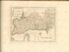


France 1:250,000, Caen
Sheet 8 of the 40-sheet map series, France 1:250 000, Series GSGS 2738. Great Britain. General Staff. Geographical Section. [London] : [GSGS, War Office]
Département de la Manche
1 Karte : Kupferdruck ; 60 x 40 cm au bureau de l'atlas national rue de la Harpe n.o 26, et au dépost de cet atlas rue de la Monnoie n.o 5
Dept. De La Manche.
1 : 455000 Levasseur, Victor.
Diocese de Coutances, [feuille 2 et 4]
2 Blätter : Dezauche
Département du Calvados
1 Karte : Kupferdruck ; 32 x 40 cm Capitaine s.n.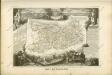

Calvados
Normandie (Francie) Levasseur, V. Aumont-Thiéville
Département du Calvados
1 Karte : Kupferdruck ; 48 x 48 cm Houdan au bureau de l'atlas national rue de la Harpe n.o 26, et au dépôt du dit atlas rue de la Monnoye n.o 5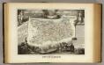
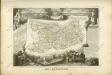
Dept. Du Calvados.
1 : 465000 Levasseur, Victor.


