Maps of Manche


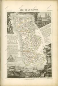
Département de la Manche
1 Karte : Kupferdruck ; 60 x 40 cm au bureau de l'atlas national rue de la Harpe n.o 26, et au dépost de cet atlas rue de la Monnoie n.o 5
Dept. De La Manche.
1 : 455000 Levasseur, Victor.
Département de la Manche
1 Karte : Kupferdruck ; 41 x 34 cm Capitaine s.n.
Le gouvernement general de Normandie, 1
1 Blatt : chez l'auteur Jaillot
Carte de la province de Normandie, 1
1 Blatt : Esnauts et Rapilly
France 1:250,000, Caen
Sheet 8 of the 40-sheet map series, France 1:250 000, Series GSGS 2738. Great Britain. General Staff. Geographical Section. [London] : [GSGS, War Office]
Diocese de Coutances, [feuille 2 et 4]
2 Blätter : Dezauche
Carte topographique du diocese de Bayeux, 1
1 Blatt : Jaillot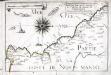
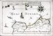
Capitaineries garde costes de Port Bail Coutenville et partie de celle de Cherbourg
1 Karte : 22 x 32 cm de Fer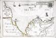
Capitaineries garde costes de Regneville Granville et de Genetz
1 Karte : 22 x 33 cm de Fer
93 La Hougue.
1 : 86400 Cassini family; Cassini, Cesar-Francois, 1714-1784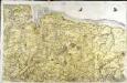
[Bayeux - Caen]
1 Blatt : 60 x 92 cm s.n.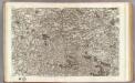
95 Vire, Avranches.
1 : 86400 Cassini family; Cassini, Cesar-Francois, 1714-1784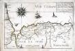
Capitaineries garde costes de Grais Port S.te Honorine Grand Camp Carentan et de la Hougue
1 Karte : 22 x 33 cm de Fer
[Vire - Avranches]
1 Blatt : 59 x 90 cm s.n.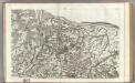
94 Bayeux, Caen.
1 : 86400 Cassini family; Cassini, Cesar-Francois, 1714-1784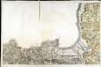
[Saint-Malo - Granville]
1 Blatt : 61 x 92 cm s.n.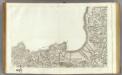
127 St.-Malo, Granville.
1 : 86400 Cassini family; Cassini, Cesar-Francois, 1714-1784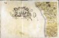
[Coutances]
1 Blatt : 60 x 92 cm Defehrt s.n.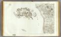
126 Coutances.
1 : 86400 Cassini family; Cassini, Cesar-Francois, 1714-1784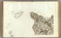
125 Cherbourg.
1 : 86400 Cassini family; Cassini, Cesar-Francois, 1714-1784
[La Hougue]
1 Blatt : 60 x 47 cm Seguin; Le Roy s.n.
France 1:50,000 , Series GSGS 4250, St. Lo
France 1:50,000 , Series GSGS 4250. Great Britain. War Office. General Staff. Geographical Section. [London] : Ordnance Survey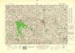
France 1:50,000 , Series GSGS 4250, Vire
France 1:50,000 , Series GSGS 4250. Great Britain. War Office. General Staff. Geographical Section. [London] : Ordnance Survey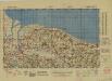
France 1:50,000 , Series GSGS 4250, Isigny
France 1:50,000 , Series GSGS 4250. Great Britain. War Office. General Staff. Geographical Section. [London] : Ordnance Survey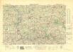
France 1:50,000 , Series GSGS 4250, Torigni-sur-Vire
France 1:50,000 , Series GSGS 4250. Great Britain. War Office. General Staff. Geographical Section. [London] : Ordnance Survey