Maps of Normandie

Normannia
1 Karte : Kupferdruck ; 47 x 56 cm L'Isle Homännische Erben
De Fransche Kanaalkust : (Cherbourg-Le Tréport)
1 : 1000000 Den Haag : Kompas
Carte de Normandie
1 Karte : Kupferdruck ; 47 x 65 cm L'Isle; Buache; Dezauche chez Dezauche graveur successeur et possesseur du fond géographique des S.rs Delisle et Buache et chargés de l'entrepo't général des cartes de la marine rue des Noyers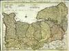
Carte de Normandie
1 Karte auf 2 Blättern : Kupferdruck ; 47 x 64 cm L'Isle; Condet chez J. Cóvens et C. Mortier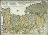
Carte de Normandie
1 Karte : Kupferdruck ; 47 x 65 cm L'Isle chez l'auteur sur le quay de l'Horloge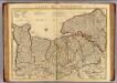
Normandie.
1 : 388000 L'Isle, Guillaume de, 1675-1726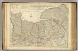
Normandie.
1 : 388000 L'Isle, Guillaume de, 1675-1726
NORMANNIA GALLIAE celebris Provincia in terras suas et Ballifiatus divisa
1 : 450000 Normandie (Francie) Delisle, Guillaume curantibus Homannianis Heredibus
NORMANNIA GALLIAE celebris Provincia in terras suas et Ballifiatus divisa
1 : 450000 Normandie (Francie) Delisle, Guillaume curantibus Homannianis Heredibus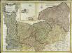
Carte de la province de Normandie
1 Karte : Kupferdruck ; 48 x 68 cm Duperrier chez l'auteur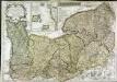
Le Duché et gouvernement de Normandie
1 Karte : Kupferdruck ; 48 x 68 cm Crépy; Crépy chez Crepy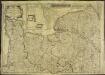
Le Duché et gouvernement de Normandie
1 Karte : Kupferdruck ; 48 x 68 cm Crépy chez Crepy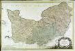
Carte de la Normandie
1 Karte auf 2 Blättern : Kupferdruck ; 62 x 96 cm Legendre; Lattré chez Lattré graveur ordinaire du roi de M. le Duc d'Orleans et de la ville rue St. Jacques a la ville de Bordeaux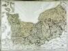
Gouvernement de Normandie
1 Karte auf 4 Blättern : Kupferdruck ; 60 x 82 cm Mentelle; Tardieu; Macquet Mentelle
Normandia ducatus
1 : 514000 Normandie (Francie) Hondius, Henricus Henricus Hondius
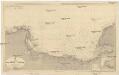
Northwestern Normandy : natural regions
1 : 550000 Provisional ed. Relief shown by shading. "Map no. 2369, 8 July 1943." "Restricted." "Reliability code: 00--2B--2." United States. Office of Strategic Services. Research and Analysis Branch [Washington, D.C.] : R & A, OSS
Carte de la province de Normandie, 1
1 Blatt : Esnauts et Rapilly
9) V.N.O. ''Le Havre'', uit: Carte géologique de France
1 : 500000 Annotatie: Voor aanwezige bladen zie bladoverzicht [S.l : s.n.]
Le gouvernement general de Normandie, 1
1 Blatt : chez l'auteur Jaillot
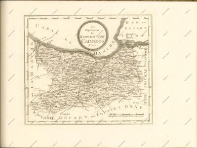
Département du Calvados
1 Karte : Kupferdruck ; 32 x 40 cm Capitaine s.n.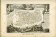

France 1:250,000, Caen
Sheet 8 of the 40-sheet map series, France 1:250 000, Series GSGS 2738. Great Britain. General Staff. Geographical Section. [London] : [GSGS, War Office]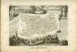
Der Kanal
1 : 150000 Francie Reichs-Marine-Amt
Département du Calvados
1 Karte : Kupferdruck ; 48 x 48 cm Houdan au bureau de l'atlas national rue de la Harpe n.o 26, et au dépôt du dit atlas rue de la Monnoye n.o 5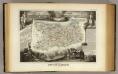
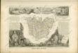
Dept. Du Calvados.
1 : 465000 Levasseur, Victor.
Calvados
Normandie (Francie) Levasseur, V. Aumont-Thiéville