Maps of Tonbridge and Malling

A topographical-map, of the county of Kent, 12
1 Blatt : 54 x 71 cm A. Dury, W. Herbert
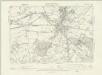
Tonbridge (Kent)(002OSD000000005U00354000)
1 : 21120 Drawing showing the area around Tonbridge in Kent. The lack of hill sketching on this drawing suggests an intermediate rather than a finished plan. Field boundaries, woodland and buildings are intricately presented. Individual trees are meticulously drawn along the avenue in Knowle Park. Measurements in ink are given in the bottom left of this drawing. A triangulation diagram appears on the reverse of the manuscript. This was used by the draughtsman to plot topographical features.
TQ64 - OS 1:25,000 Provisional Series Map
1 : 25000 Topographic maps Ordnance Survey Ordnance Survey
Tonbridge (Kent)(002OSD000000005U00352000)
1 : 21120 Drawing showing the area around Tonbridge in Kent. Annotations in ink confirm these drawings as being field sketches. The loose nature of the hill sketching contrasts with that of later, finished drawings. A cross marked Bluborough indicates an observation station from which angular measurements were taken during the surveying.
TQ74 - OS 1:25,000 Provisional Series Map
1 : 25000 Topographic maps Ordnance Survey Ordnance Survey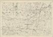
Kent LI - OS Six-Inch Map
1 : 10560 Topographic maps Ordnance Survey Ordnance Survey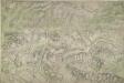
Addington (Kent)
1 : 10560 This map of north-west Kent is drawn on rectangular sheet lines and enclosed by a black border. Fields are coloured brown where cultivated, and green or blank if untilled. Stonework buildings and structures are drawn in red ink at major settlements. Infilled or blocked areas of black or sepia ink indicate structures and buildings made from less permanent materials, such as wood. Spot heights (altitudes)are drawn in red ink figures. This is the earliest plan to distinguish pictorially between coniferous and deciduous trees.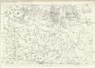
Kent LII - OS Six-Inch Map
1 : 10560 Topographic maps Ordnance Survey Ordnance Survey
Mereworth, Kent
1 : 10560 Irregular field boundaries enclosing agricultural land dominate the Medway Valley in Kent, around the main settlements of Hadlow, Mereworth and Yalding. Rays in red ink intersect the map, evidence of measurements taken by the surveyor between fixed triangulation points. The ruled black-sheet lines indicate the edges of the area that was copied for plans 100 and 119.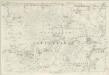
Kent XLI - OS Six-Inch Map
1 : 10560 Topographic maps Ordnance Survey Ordnance Survey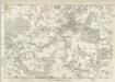
Kent XLII - OS Six-Inch Map
1 : 10560 Topographic maps Ordnance Survey Ordnance Survey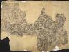
Penshurst Park, Kent
1 : 21120 Drawing of the area around Penshurst Park, to the west of Tonbridge in Kent. Although this field sketch appears loosely drawn, it includes carefully observed details such as the layout of avenues of trees in Penshurst Park itself.
TQ65 - OS 1:25,000 Provisional Series Map
1 : 25000 Topographic maps Ordnance Survey Ordnance Survey
TQ75 - OS 1:25,000 Provisional Series Map
1 : 25000 Topographic maps Ordnance Survey Ordnance Survey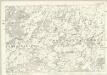
Kent LXI - OS Six-Inch Map
1 : 10560 Topographic maps Ordnance Survey Ordnance Survey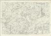
Kent LXII - OS Six-Inch Map
1 : 10560 Topographic maps Ordnance Survey Ordnance Survey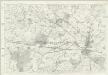
Kent L - OS Six-Inch Map
1 : 10560 Topographic maps Ordnance Survey Ordnance Survey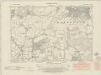
Kent XL.SE - OS Six-Inch Map
1 : 10560 Topographic maps Ordnance Survey Ordnance Survey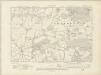
Kent XL.SE - OS Six-Inch Map
1 : 10560 Topographic maps Ordnance Survey Ordnance Survey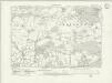
Kent XL.SE - OS Six-Inch Map
1 : 10560 Topographic maps Ordnance Survey Ordnance Survey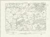
Kent XL.SE - OS Six-Inch Map
1 : 10560 Topographic maps Ordnance Survey Ordnance Survey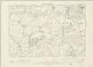
Kent XL.SE - OS Six-Inch Map
1 : 10560 Topographic maps Ordnance Survey Ordnance Survey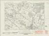
Kent L.NE - OS Six-Inch Map
1 : 10560 Topographic maps Ordnance Survey Ordnance Survey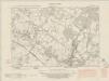
Kent L.NE - OS Six-Inch Map
1 : 10560 Topographic maps Ordnance Survey Ordnance Survey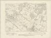
Kent L.NE - OS Six-Inch Map
1 : 10560 Topographic maps Ordnance Survey Ordnance Survey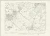
Kent L.NE - OS Six-Inch Map
1 : 10560 Topographic maps Ordnance Survey Ordnance Survey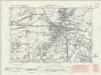
Kent L.SE - OS Six-Inch Map
1 : 10560 Topographic maps Ordnance Survey Ordnance Survey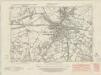
Kent L.SE - OS Six-Inch Map
1 : 10560 Topographic maps Ordnance Survey Ordnance Survey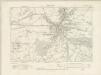
Kent L.SE - OS Six-Inch Map
1 : 10560 Topographic maps Ordnance Survey Ordnance Survey