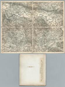
Maps of Rinteln

309. Lemgo.
1 : 100000 Reichsamt fur Landesaufnahme
Meßtischblatt 2152 : Bösingfeld, 1932
1 : 250000 Bösingfeld. - Hrsg. 1912, einz. Nachtr. 1932. - 1:25000. - [Berlin]: Reichsamt für Landesaufnahme, 1932. - 1 Kt.
Meßtischblatt 2151 : Lemgo, 1912
1 : 250000 Lemgo. - Aufn. 1910. - 1:25000. - [Berlin]: Reichsamt für Landesaufnahme, 1912. - 1 Kt.
Meßtischblatt 2085 : Rinteln, 1932
1 : 250000 Rinteln. - Hrsg. 1898/1912, bericht. 1911, einz. Nachtr. 1932. - 1:25000. - [Berlin]: Reichsamt für Landesaufnahme, 1932. - 1 Kt.
Meßtischblatt 2085, 2152 : Rinteln, 1898
1 : 250000 Rinteln. - Aufn. 1896. - 1:25000. - [Berlin]: Reichsamt für Landesaufnahme, 1898. - 1 Kt.
Meßtischblatt 2084 : Vlotho, 1930
1 : 250000 Vlotho. - Hrsg. 1912, einz. Nachtr. 1926, gedr. [19]30. - 1:25000. - [Berlin]: Reichsamt für Landesaufnahme, 1930. - 1 Kt.
Meßtischblatt 2084 : Vlotho, 1898
1 : 250000 Vlotho. - Aufn. 1896. - 1:25000. - [Berlin]: Reichsamt für Landesaufnahme, 1898. - 1 Kt.
Meßtischblatt 2153 : Ärzen, 1897
1 : 250000 Ärzen. - Aufn. 1896. - 1:25000. - [Berlin]: Reichsamt für Landesaufnahme, 1897. - 1 Kt.
Meßtischblatt 2086 : Hess. Oldendorf, 1898
1 : 250000 Hess. Oldendorf. - Aufn. 1896, hrsg. 1898. - 1:25000. - [Berlin]: Reichsamt für Landesaufnahme, 1898. - 1 Kt.
Meßtischblatt 2016 : Minden, 1921
1 : 250000 Minden. - Aufn. 1896, Nachtr. 1921. - 1:25000. - [Berlin]: Reichsamt für Landesaufnahme, 1921. - 1 Kt.
Meßtischblatt 2016 : Minden, 1914
1 : 250000 Minden. - Aufn. 1896, hrsg. 1898, Aufl.-dr. 1914. - 1:25000. - [Berlin]: Reichsamt für Landesaufnahme, 1914. - 1 Kt.
Meßtischblatt 2017 : Bückeburg, 1929
1 : 250000 Bückeburg. - Hrsg. 1898, bericht. 1924, einz. Nachtr. 1929. - 1:25000. - [Berlin]: Reichsamt für Landesaufnahme, 1929. - 1 Kt.
Meßtischblatt 2018 : Kathrinhagen, 1913
1 : 250000 Kathrinhagen. - Aufn. 1896, hrsg. 1898, Auflagendr. 1913. - 1:25000. - [Berlin]: Reichsamt für Landesaufnahme, 1913. - 1 Kt.
Composite: 309. Lemgo.
1 : 100000 Reichsamt fur Landesaufnahme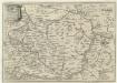
Descriptio Comitatus Lippiensis.
Mollova mapová sbírka Hoffmann, Jakob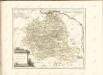

Topographish-petrographische Karte des Fürstenthums Pyrmont und dessen Umgegend
1 : 70000 Dolní Sasko (Německo) Curtze, G. Kirchner, W. Georg Uslar
Die Grafschaft Pyrmont
1 : 50000 Mollova mapová sbírka Overheide, J. A. Homann, Johann Baptista - dědici
Meßtischblatt 2150 : Salzuflen, 1932
1 : 250000 Salzuflen. - Hrsg. 1912, einz. Nachtr. 1926, gedr. [19]32. - 1:25000. - [Berlin]: Reichsamt für Landesaufnahme, 1932. - 1 Kt.
Meßtischblatt 2150 : Salzuflen, 1912
1 : 250000 Salzuflen. - Aufn. 1910. - 1:25000. - [Berlin]: Reichsamt für Landesaufnahme, 1912. - 1 Kt.
Meßtischblatt 2083 : Herford (Ost), 1926
1 : 250000 Herford (Ost). - Aufn. 1895, einz. Nachtr. 1926. - 1:25000. - [Berlin]: Reichsamt für Landesaufnahme, 1926. - 1 Kt.
Meßtischblatt 2083 : Herford (Ost), 1897
1 : 250000 Herford (Ost). - Aufn. 1895. - 1:25000. - [Berlin]: Reichsamt für Landesaufnahme, 1897. - 1 Kt.
Die umliegenden Gegenden um Minden, und die Schlacht bey Gofeld vom 1sten des Augustmonats, 1759
Minden (Německo) Trattner, Johann Thomas
Carte géographique du comté de Lippe
1 : 119000 Lippe (Německo) Lotter, Tobias Conrad Lotter, Georg F. par Tobie Conrad Lotter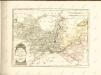

Minden 57, uit: Special-Karte von Mittel-Europa / nach amtlichen Quellen bearbeitet von W. Liebenow
1 : 300000 titelvariant: W. Liebenow's Mittel-Europa; Annotatie: Titel boven de bladen: W. Liebenow's Mittel-Europa Johannes Wilhelm Liebenow 1822-1897 Frankfurt a. M. : Ludwig Ravenstein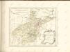

Minden 57, uit: [W. Liebenow's Special-Karte von Mittel-Europa]
1 : 300000 titelvariant: W. Liebenow's Mittel-Europa; Annotatie: Titel boven de bladen: W. Liebenow's Mittel-Europa Johannes Wilhelm Liebenow 1822-1897 Hannover : Hermann Oppermann
Episcopatvs Paderborn nec non Abbatiae Corvei Territorium seculare
1 : 190000 Mollova mapová sbírka Gigas, Johann Michael Homann, Johann Baptista - dědici