Maps of Kalletal

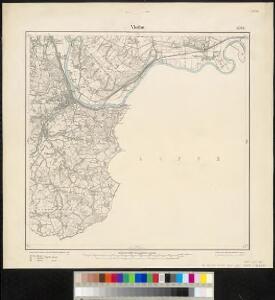
Meßtischblatt 2084 : Vlotho, 1930
1 : 250000 Vlotho. - Hrsg. 1912, einz. Nachtr. 1926, gedr. [19]30. - 1:25000. - [Berlin]: Reichsamt für Landesaufnahme, 1930. - 1 Kt.
Meßtischblatt 2084 : Vlotho, 1898
1 : 250000 Vlotho. - Aufn. 1896. - 1:25000. - [Berlin]: Reichsamt für Landesaufnahme, 1898. - 1 Kt.
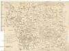
309. Lemgo.
1 : 100000 Reichsamt fur Landesaufnahme
Composite: 309. Lemgo.
1 : 100000 Reichsamt fur Landesaufnahme
85. Minden, uit: Topographische Uebersichtskarte des Deutschen Reiches / herausgegeben v. d. Kartogr. Abt. d. Königl. Preuß. Landesaufnahme
1 : 200000 titelvariant: Topogr. Übersichtskarte des Deutschen Reiches; Annotatie: Titel boven bladen ook: Topogr. Übersichtskarte des Deutschen Reiches; Annotatie geografische gegevens: Op elk blad twee maatstokken: 10 Kilometer = 5,5 cm; 1 geogr. Meile = 3,6 cm; Legenda onder op elk blad Königlich Preußische Landesaufnahme. Kartographische Abtheilung [S.l : Königlich Preußische Landesaufnahme, Kartographische Abtheilung]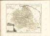
Descriptio Comitatus Lippiensis.
Mollova mapová sbírka Hoffmann, Jakob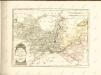

Die umliegenden Gegenden um Minden, und die Schlacht bey Gofeld vom 1sten des Augustmonats, 1759
Minden (Německo) Trattner, Johann Thomas
Minden 57, uit: [W. Liebenow's Special-Karte von Mittel-Europa]
1 : 300000 titelvariant: W. Liebenow's Mittel-Europa; Annotatie: Titel boven de bladen: W. Liebenow's Mittel-Europa Johannes Wilhelm Liebenow 1822-1897 Hannover : Hermann Oppermann
Minden 57, uit: Special-Karte von Mittel-Europa / nach amtlichen Quellen bearbeitet von W. Liebenow
1 : 300000 titelvariant: W. Liebenow's Mittel-Europa; Annotatie: Titel boven de bladen: W. Liebenow's Mittel-Europa Johannes Wilhelm Liebenow 1822-1897 Frankfurt a. M. : Ludwig Ravenstein
Carte géographique du comté de Lippe
1 : 119000 Lippe (Německo) Lotter, Tobias Conrad Lotter, Georg F. par Tobie Conrad Lotter
DUCATUS BRUNSVICENSIS FEREQUE LUNAEBURGENSIS
1 : 370000 Braunschweig (Německo) Visscher, Claes Jansz. C.I. Visscher excudit
Übersichts Karte der Operationen von der Schlacht bei Vellinghausen bis zum Übergange des Marschalls Broglio über die Weser, vom 16ten Juli bis 21ten August 1761
Carta delli dvcati di Brvnsvvic, e Lvnebvrg
1 : 368000 Braunschweig (Německo : historické území)
Ducatus Brunsuicensis
1 : 400000 Braunschweig (Německo : historické území) Homann, Johann Baptist Ioh. Bapt. Homanni
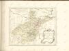
Carte Du Théatre De La Guerre Présente En Westphaliae Avec Les Pays Voisins
1 : 290000 Mollova mapová sbírka Rizzi Zannoni, Giovanni Antonio Back, Jakob Conrad Broenner, Heinrich Ludwig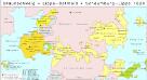
Braunschweig, Lippe-Detmold, Schaumburg-Lippe 1820
Staat Braunschweig, Lippe-Detmold Kunz, Andreas ; Moeschl, Joachim Robert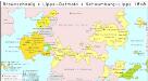
Braunschweig, Lippe-Detmold, Schaumburg-Lippe 1848
Staat Braunschweig, Lippe-Detmold Kunz, Andreas ; Moeschl, Joachim Robert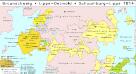
Braunschweig, Lippe-Detmold, Schaumburg-Lippe 1814
Staat Braunschweig, Lippe-Detmold Kunz, Andreas ; Moeschl, Joachim Robert
Ducatus Brunsuicensis
1 : 385000 Braunschweig (Německo : historické území) Seutter, Matthäus sumptibus Matthaei Seutteri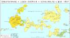
Braunschweig, Lippe-Detmold, Schaumburg-Lippe 1867
Staat Braunschweig, Lippe-Detmold Kunz, Andreas ; Moeschl, Joachim Robert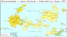
Braunschweig, Lippe-Detmold, Schaumburg-Lippe 1871
Staat Braunschweig, Lippe-Detmold Kunz, Andreas ; Moeschl, Joachim Robert
Ducatus Brunsuicensis
1 : 394000 Braunschweig (Německo) Homann, Johann Baptist cura Ioh. Bapt. Homanni
Dvcatvs Brvnsvicensis fereq. Lvnaeburgensis
1 : 540000 Mollova mapová sbírka Merian, Matthaeus Merian, Matthäus - dědici
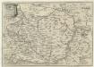
[Westfaliae secunda tabula]
1 Karte : Kupferdruck ; 34 x 44 cm Mercator; Hondius sumptibus Henrici Hondij
[Westfaliae secunda tabula]
1 Karte : Kupferdruck ; 34 x 44 cm Mercator s.n.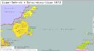
Lippe-Detmold, Schaumburg-Lippe 1812
Lippe-Detmold, Schaumburg-Lippe Hundt, Michael