Maps of Bad Salzuflen

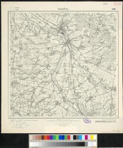
Meßtischblatt 2150 : Salzuflen, 1932
1 : 250000 Salzuflen. - Hrsg. 1912, einz. Nachtr. 1926, gedr. [19]32. - 1:25000. - [Berlin]: Reichsamt für Landesaufnahme, 1932. - 1 Kt.
Meßtischblatt 2150 : Salzuflen, 1912
1 : 250000 Salzuflen. - Aufn. 1910. - 1:25000. - [Berlin]: Reichsamt für Landesaufnahme, 1912. - 1 Kt.
308. Bielefeld.
1 : 100000 Reichsamt fur Landesaufnahme
Composite: 308. Bielefeld.
1 : 100000 Reichsamt fur Landesaufnahme
203. Bunde. (Germany)
1 : 100000 Reichsamt fur Landesaufnahme
Composite: 309. Lemgo.
1 : 100000 Reichsamt fur Landesaufnahme
Descriptio Comitatus Lippiensis.
Mollova mapová sbírka Hoffmann, Jakob
Carte géographique du comté de Lippe
1 : 119000 Lippe (Německo) Lotter, Tobias Conrad Lotter, Georg F. par Tobie Conrad Lotter
Die umliegenden Gegenden um Minden, und die Schlacht bey Gofeld vom 1sten des Augustmonats, 1759
Minden (Německo) Trattner, Johann Thomas
Episcopatvs Paderborn nec non Abbatiae Corvei Territorium seculare
1 : 190000 Mollova mapová sbírka Gigas, Johann Michael Homann, Johann Baptista - dědici
Minden 57, uit: [W. Liebenow's Special-Karte von Mittel-Europa]
1 : 300000 titelvariant: W. Liebenow's Mittel-Europa; Annotatie: Titel boven de bladen: W. Liebenow's Mittel-Europa Johannes Wilhelm Liebenow 1822-1897 Hannover : Hermann Oppermann
Osnabrvgensis episcopatvs
1 : 236000 Osnabrück (Německo) Gigas, Johann Michael Blaeu, Willem Janszoon Guilielm Blaeuw
Minden 57, uit: Special-Karte von Mittel-Europa / nach amtlichen Quellen bearbeitet von W. Liebenow
1 : 300000 titelvariant: W. Liebenow's Mittel-Europa; Annotatie: Titel boven de bladen: W. Liebenow's Mittel-Europa Johannes Wilhelm Liebenow 1822-1897 Frankfurt a. M. : Ludwig Ravenstein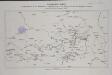
Übersichts Karte der Operationen von der Schlacht bei Vellinghausen bis zum Übergange des Marschalls Broglio über die Weser, vom 16ten Juli bis 21ten August 1761

Carte Du Théatre De La Guerre Présente En Westphaliae Avec Les Pays Voisins
1 : 290000 Mollova mapová sbírka Rizzi Zannoni, Giovanni Antonio Back, Jakob Conrad Broenner, Heinrich Ludwig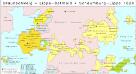
Braunschweig, Lippe-Detmold, Schaumburg-Lippe 1820
Staat Braunschweig, Lippe-Detmold Kunz, Andreas ; Moeschl, Joachim Robert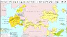
Braunschweig, Lippe-Detmold, Schaumburg-Lippe 1848
Staat Braunschweig, Lippe-Detmold Kunz, Andreas ; Moeschl, Joachim Robert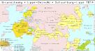
Braunschweig, Lippe-Detmold, Schaumburg-Lippe 1814
Staat Braunschweig, Lippe-Detmold Kunz, Andreas ; Moeschl, Joachim Robert
Braunschweig, Lippe-Detmold, Schaumburg-Lippe 1867
Staat Braunschweig, Lippe-Detmold Kunz, Andreas ; Moeschl, Joachim Robert
Braunschweig, Lippe-Detmold, Schaumburg-Lippe 1871
Staat Braunschweig, Lippe-Detmold Kunz, Andreas ; Moeschl, Joachim Robert
[Westfaliae secunda tabula]
1 Karte : Kupferdruck ; 34 x 44 cm Mercator; Hondius sumptibus Henrici Hondij
[Westfaliae secunda tabula]
1 Karte : Kupferdruck ; 34 x 44 cm Mercator s.n.
Lippe-Detmold, Schaumburg-Lippe 1812
Lippe-Detmold, Schaumburg-Lippe Hundt, Michael
Hassia Superior
1 : 360000 Mollova mapová sbírka Valk, Gerhard Schenk, Peter I
Episcopatuum Monasteriensis et Osnabrugensis ut et comitatum Bentheim, Teclenburg, Stenford, Lingen, Diepholt, Delmenhorst, Rietberg etc. etc. novissima et accuratissima designatio
1 : 330000 cura et sumptibus Tobiae Conradi Lotter Tob. Con. Lotter sculp. Aug. Vind : Tob. Conr. Lotter

Episcopatus Monasteriensis et Osnabrugensis nec non Comitatuum Bentheim Teckelenburg Stanford Lingen Diepholt Delmenhorst Ritberg etc. Tabula
1 : 410000 Mollova mapová sbírka Danckerts, Justus Danckerts, Justus
Charte von Wesergebirge
1 : 925000