Maps of Kreis Lippe
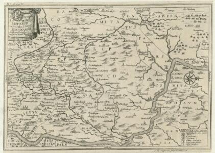
Descriptio Comitatus Lippiensis.
Mollova mapová sbírka Hoffmann, Jakob

Die umliegenden Gegenden um Minden, und die Schlacht bey Gofeld vom 1sten des Augustmonats, 1759
Minden (Německo) Trattner, Johann Thomas
Carte géographique du comté de Lippe
1 : 119000 Lippe (Německo) Lotter, Tobias Conrad Lotter, Georg F. par Tobie Conrad Lotter
Composite: 309. Lemgo.
1 : 100000 Reichsamt fur Landesaufnahme
309. Lemgo.
1 : 100000 Reichsamt fur Landesaufnahme
Topographish-petrographische Karte des Fürstenthums Pyrmont und dessen Umgegend
1 : 70000 Dolní Sasko (Německo) Curtze, G. Kirchner, W. Georg Uslar
Die Grafschaft Pyrmont
1 : 50000 Mollova mapová sbírka Overheide, J. A. Homann, Johann Baptista - dědici
333. Detmold.
1 : 100000 Reichsamt fur Landesaufnahme
Composite: 333. Detmold.
1 : 100000 Reichsamt fur Landesaufnahme
Composite: 308. Bielefeld.
1 : 100000 Reichsamt fur Landesaufnahme
308. Bielefeld.
1 : 100000 Reichsamt fur Landesaufnahme

Meßtischblatt 2296 : Schwalenberg, 1924
1 : 250000 Schwalenberg. - Aufn. 1896, kl. Nachtr. 1924. - 1:25000. - [Berlin]: Reichsamt für Landesaufnahme, 1924. - 1 Kt.
Meßtischblatt 2295 : Steinheim, 1932
1 : 250000 Steinheim. - Hrsg. 1898, bericht. 1912, einz. Nachtr. 1932. - 1:25000. - [Berlin]: Reichsamt für Landesaufnahme, 1932. - 1 Kt.
Meßtischblatt 2294 : Horn, 1932
1 : 250000 Horn. - Hrsg. 1912, Nachtr. 1932. - 1:25000. - [Berlin]: Reichsamt für Landesaufnahme, 1932. - 1 Kt.
Meßtischblatt 2294 : Sandebeck, 1898
1 : 250000 Sandebeck. - Aufn. 1896. - 1:25000. - [Berlin]: Reichsamt für Landesaufnahme, 1898. - 1 Kt.
Meßtischblatt 2293 : Senne, 1897
1 : 250000 Senne. - Aufn. 1895. - 1:25000. - [Berlin]: Reichsamt für Landesaufnahme, 1897. - 1 Kt.
Meßtischblatt 2224 : Ottenstein (in Braunschweig), 1897
1 : 250000 Ottenstein (in Braunschweig). - Aufn. 1896. - 1:25000. - [Berlin]: Reichsamt für Landesaufnahme, 1897. - 1 Kt.
Meßtischblatt 2223 : Bad Pyrmont, 1936
1 : 250000 Bad Pyrmont. - Hrsg. 1898, bericht. 1912, einz. Nachtr. 1932. - 1:25000. - [Berlin]: Reichsamt für Landesaufnahme, 1936. - 1 Kt.
Meßtischblatt 2222, neue 4020 : Blomberg, 1944
1 : 250000 Blomberg. - Hrsg. 1911, einz. Nachtr. 1937, gedr. 1944. - 1:25000. - [Berlin]: Reichsamt für Landesaufnahme, 1944. - 1 Kt.
Meßtischblatt 4019 : Detmold, 1950
1 : 250000 Detmold. - Aufn. 1912, hrsg. 1912, letzte Nachtr. 1937. - 1:25000. - Münster : Landesvermessungsamt, 1950. - 1 Kt.
Meßtischblatt 2220 : Lage, 1937
1 : 250000 Lage. - Hrsg. 1912, einz. Nachtr. 1921, gedr. [19]37. - 1:25000. - [Berlin]: Reichsamt für Landesaufnahme, 1937. - 1 Kt.
Meßtischblatt 2154 : Kirchohsen, 1934
1 : 250000 Kirchohsen. - Aufn. 1896, Nachtr. 1926, gedr. [19]34. - 1:25000. - [Berlin]: Reichsamt für Landesaufnahme, 1934. - 1 Kt.
Meßtischblatt 2154 : Kirchohsen, 1898
1 : 250000 Kirchohsen. - Aufn. 1896. - 1:25000. - [Berlin]: Reichsamt für Landesaufnahme, 1898. - 1 Kt.
Meßtischblatt 2153 : Ärzen, 1897
1 : 250000 Ärzen. - Aufn. 1896. - 1:25000. - [Berlin]: Reichsamt für Landesaufnahme, 1897. - 1 Kt.
Meßtischblatt 2152 : Bösingfeld, 1932
1 : 250000 Bösingfeld. - Hrsg. 1912, einz. Nachtr. 1932. - 1:25000. - [Berlin]: Reichsamt für Landesaufnahme, 1932. - 1 Kt.
Meßtischblatt 2151 : Lemgo, 1912
1 : 250000 Lemgo. - Aufn. 1910. - 1:25000. - [Berlin]: Reichsamt für Landesaufnahme, 1912. - 1 Kt.
Meßtischblatt 2150 : Salzuflen, 1932
1 : 250000 Salzuflen. - Hrsg. 1912, einz. Nachtr. 1926, gedr. [19]32. - 1:25000. - [Berlin]: Reichsamt für Landesaufnahme, 1932. - 1 Kt.