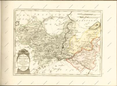
Maps of Kreis Minden-Lübbecke
Germany/Central Europe 1:100,000, Minden
Germany / Central Europe 1:100,000, Series GSGS 4416. Great Britain. War Office. [London] : Ordnance Survey
Plan de la bataille de Tonhausen

Composite: 284. Lubbecke.
1 : 100000 Reichsamt fur Landesaufnahme
Composite: 309. Lemgo.
1 : 100000 Reichsamt fur Landesaufnahme
284. Lubbecke.
1 : 100000 Reichsamt fur Landesaufnahme
285. Minden.
1 : 100000 Reichsamt fur Landesaufnahme
Composite: 285. Minden.
1 : 100000 Reichsamt fur Landesaufnahme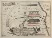
Bataille welche der Herzog Ferdinand über die Franzosische Haupt-Armee ohnweit Minden d. 1. August 1759 mit Ruhm erfochten
1 : 100000
Plan de la Bataille de Tonhausen
1 : 100000 Mollova mapová sbírka Bauer, Friedrich Wilhelm von Schley, Jacobus van der Hondt, Pierre de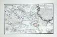
Plan der Battaille bey Minden zwischen der Französ. Armee unter Commando des Mr. des Contades und der Alliirten Armee commandirt von Sr. Durchl. den Herzog Ferdinand von Braunschweig den 1ten Augustus 1759

309. Lemgo.
1 : 100000 Reichsamt fur Landesaufnahme
203. Bunde. (Germany)
1 : 100000 Reichsamt fur Landesaufnahme
Composite: 308. Bielefeld.
1 : 100000 Reichsamt fur Landesaufnahme
308. Bielefeld.
1 : 100000 Reichsamt fur Landesaufnahme
Meßtischblatt 2086 : Hess. Oldendorf, 1898
1 : 250000 Hess. Oldendorf. - Aufn. 1896, hrsg. 1898. - 1:25000. - [Berlin]: Reichsamt für Landesaufnahme, 1898. - 1 Kt.
Meßtischblatt 2085 : Rinteln, 1932
1 : 250000 Rinteln. - Hrsg. 1898/1912, bericht. 1911, einz. Nachtr. 1932. - 1:25000. - [Berlin]: Reichsamt für Landesaufnahme, 1932. - 1 Kt.
Meßtischblatt 2085, 2152 : Rinteln, 1898
1 : 250000 Rinteln. - Aufn. 1896. - 1:25000. - [Berlin]: Reichsamt für Landesaufnahme, 1898. - 1 Kt.
Meßtischblatt 2084 : Vlotho, 1930
1 : 250000 Vlotho. - Hrsg. 1912, einz. Nachtr. 1926, gedr. [19]30. - 1:25000. - [Berlin]: Reichsamt für Landesaufnahme, 1930. - 1 Kt.
Meßtischblatt 2084 : Vlotho, 1898
1 : 250000 Vlotho. - Aufn. 1896. - 1:25000. - [Berlin]: Reichsamt für Landesaufnahme, 1898. - 1 Kt.
Meßtischblatt 2083 : Herford (Ost), 1926
1 : 250000 Herford (Ost). - Aufn. 1895, einz. Nachtr. 1926. - 1:25000. - [Berlin]: Reichsamt für Landesaufnahme, 1926. - 1 Kt.
Meßtischblatt 2083 : Herford (Ost), 1897
1 : 250000 Herford (Ost). - Aufn. 1895. - 1:25000. - [Berlin]: Reichsamt für Landesaufnahme, 1897. - 1 Kt.
Meßtischblatt 2082 : Herford (West), 1926
1 : 250000 Herford (West). - Aufn. 1895, einz. Nachtr. 1926. - 1:25000. - [Berlin]: Reichsamt für Landesaufnahme, 1926. - 1 Kt.
Meßtischblatt 2082 : Herford (West), 1897
1 : 250000 Herford (West). - Aufn. 1895. - 1:25000. - [Berlin]: Reichsamt für Landesaufnahme, 1897. - 1 Kt.
Meßtischblatt 2081 : Neuenkirchen (Kr. Melle), 1936
1 : 250000 Neuenkirchen (Kr. Melle). - Aufn. 1895, bericht. 1912, einz. Nachtr. 1926, gedr. [19]36. - 1:25000. - [Berlin]: Reichsamt für Landesaufnahme, 1936. - 1 Kt.
Meßtischblatt 2081 : Neuenkirchen (Kr. Melle), 1897
1 : 250000 Neuenkirchen (Kr. Melle). - Aufn. 1895. - 1:25000. - [Berlin]: Reichsamt für Landesaufnahme, 1897. - 1 Kt.
Meßtischblatt 2018 : Kathrinhagen, 1913
1 : 250000 Kathrinhagen. - Aufn. 1896, hrsg. 1898, Auflagendr. 1913. - 1:25000. - [Berlin]: Reichsamt für Landesaufnahme, 1913. - 1 Kt.
Meßtischblatt 2017 : Bückeburg, 1929
1 : 250000 Bückeburg. - Hrsg. 1898, bericht. 1924, einz. Nachtr. 1929. - 1:25000. - [Berlin]: Reichsamt für Landesaufnahme, 1929. - 1 Kt.
Meßtischblatt 2016 : Minden, 1921
1 : 250000 Minden. - Aufn. 1896, Nachtr. 1921. - 1:25000. - [Berlin]: Reichsamt für Landesaufnahme, 1921. - 1 Kt.