Maps of Minnesota

State of Kansas, and Nebraska and Indian Territories.
1 : 3000000 Colton, G.W.
Kansas, and Nebraska and Indian Territories.
1 : 3000000 Colton, G.W.
Commercial Map, Chicago to Denver.
1 : 3950000 Rand McNally and Company
Nebraska And Kansas.
1 : 3850000 Colton, J. H.
Spojené státy severoamerické II. Prostřední část
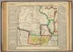
Map Of Arkansas Territory.
1 : 4752000 Lea, I.
(United States) Denver to Chicago.
1 : 3802000 Rand McNally and Company
Shell Highway Map of Central United States.
1 : 3421440 Shell Oil Company
Country drained by the Mississippi Western Section.
1 : 4752000 Long, Stephen H.
Map of an exploring expedition to the Rocky Mountains in the year 1842 and to Oregon & north California in the years 1843-44 / by Brevet Capt. J.C. Frémont of the Corps of Topographical Engineers under the orders of Col. J.J. Abert, Chief of the Topog...
From Parts
Map showing the lands assigned to emigrant Indians west of Arkansas & Missouri / prepared at the Topographical Bureau Feby. 23d, 1836, [by] R. Jones, Adj. Gene.
from Parts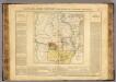
Arkansas.
1 : 4700000 Buchon, J. A. C.; Carey, H. C.; Lea, I.
Nebraska and Kansas.
1 : 3850000 Colton, J. H.
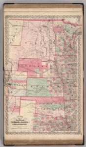
Map of Kansas, Nebraska, and Colorado. Showing also the eastern portion of Idaho.
from New general atlas.
Nebraska and Kansas.
1 : 3850000 Colton, J. H.
Nebraska And Kanzas.
1 : 4800000 Colton, G.W.
Vereinigte Staaten Von Nord-Amerika In 6 Blattern, Bl. 2.
1 : 3700000 Petermann, A.
A Map of the British Empire in America. (Sheet 5).
1 : 2000000 Popple, Henry
Nebraska and Kansas.
1 : 3850000 Colton, J. H.
Nebraska and Kansas. Minnesota.
1 : 3623775 Fisher, Richard Swainson
[Die Vereinigten Staaten von Nord-Amerika, Blatt 2]
Handatlas über alle Theile der Erde und über das Weltgebäude Stieler, Adolf Justus Perthes
[Die Vereinigten Staaten von Amerika in 6 Blättern, Blatt 2]
Adolf Stieler's Handatlas über alle Theile der Erde und über das Weltgebäude Stieler, Adolf Justus Perthes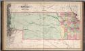
A New Map of Kansas.
1 : 1457280 Mitchell, Samuel Augustus
Nebraska, Kansas, New Mexico, and Indian Territories
1 : 6600000 Mitchell, Samuel Augustus
Nebraska, Kansas, New Mexico, and Indian Territories
1 : 6600000 Mitchell, Samuel Augustus
Kansas, Texas, Indian Territory.
1 : 1900000 United States. War Department
Indian Territory, Northern Texas and New Mexico.
1 : 3600000 Gregg, Josiah, 1806-1850
Indian Terr., N. Texas, N.M.
1 : 3500000 Morse, Sidney E. (Sidney Edwards), 1794-1871
Hydrographical Basin of the Upper Mississippi River.
1 : 1200000 Nicollet, J. N. (Joseph Nicolas), 1786-1843