Maps of Ozark Plateau
Arkansas.
1 : 4700000 Buchon, J. A. C.; Carey, H. C.; Lea, I.
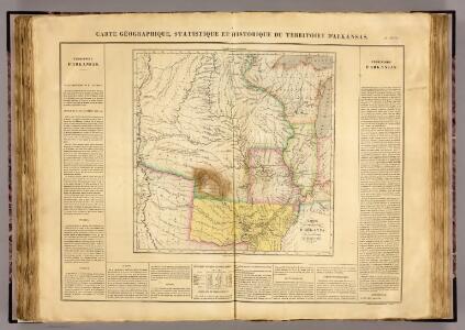
Map Of Arkansas Territory.
1 : 4752000 Lea, I.
(United States) Denver to Chicago.
1 : 3802000 Rand McNally and Company
Commercial Map, Chicago to Denver.
1 : 3950000 Rand McNally and Company
Composite: Country drained by the Mississippi.
1 : 4625280 Long, Stephen H.
Spojené státy severoamerické II. Prostřední část

Kansas, and Nebraska and Indian Territories.
1 : 3000000 Colton, G.W.
Map of an exploring expedition to the Rocky Mountains in the year 1842 and to Oregon & north California in the years 1843-44 / by Brevet Capt. J.C. Frémont of the Corps of Topographical Engineers under the orders of Col. J.J. Abert, Chief of the Topog...
From Parts
State of Kansas, and Nebraska and Indian Territories.
1 : 3000000 Colton, G.W.
Map showing the lands assigned to emigrant Indians west of Arkansas & Missouri / prepared at the Topographical Bureau Feby. 23d, 1836, [by] R. Jones, Adj. Gene.
from Parts
Les États Unis de l'Amérique septentrionale
1 : 6050000 Spojené státy americké-oblast západní Bonne, Rigobert André
Country drained by the Mississippi Western Section.
1 : 4752000 Long, Stephen H.
Il paese de' Selvaggi Outagamiani, Mascoutensi, Illinesi, e parte delle VI. Nazioni.
from Le colonie unite dell' America settentrle : di nuova projezione a s.s.e.e. li Signori Riformatori dello Studio di Padova.
Map of Kansas, Nebraska, and Colorado. Showing also the eastern portion of Idaho.
from New general atlas.
Post route map of the states of Kansas and Nebraska : showing post offices with the intermediate distances and mail routes in operation on the 1st of December, 1900 / published by order of Postmaster General Charles Emory Smith under the direction of ...
From Parts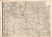
A Map of the British Empire in America. (Sheet 5).
1 : 2000000 Popple, Henry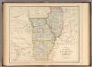
States Of Illinois, Missouri, And Arkansas.
1 : 3453120 Rogers, Henry Darwin
Nebraska and Kansas.
1 : 3850000 Colton, J. H.
[Horní tok Mississippi]
Mississippi, řeka-oblast
County map of the States of Iowa and Missouri.
from Mitchell's new general atlas, containing maps of the various countries of the world, plans of cities, etc., embraced in fifty-three quarto maps., forming a series of eighty four maps and plans, together with valuable statistical tables.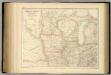
United States ... North Central Section.
1 : 2851200 Fullarton, A. & Co.
Illinois, Iowa, and Missouri.
1 : 3651000 Fisher, Richard Swainson
Nebraska and Kansas.
1 : 3850000 Colton, J. H.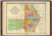
Map of the State of Missouri And Territory of Arkansas.
1 : 2200000 Finley, Anthony
Vereinigte Staaten Von Nord-Amerika In 6 Blattern, Bl. 2.
1 : 3700000 Petermann, A.
Nebraska and Kansas. Minnesota.
1 : 3623775 Fisher, Richard Swainson
Illinois, Missouri, Iowa, Nebraska And Kansas.
1 : 3600000 Mitchell, Samuel Augustus
Nebraska and Kansas.
1 : 3850000 Colton, J. H.
Shell Sectional Map No. 7 - South Central States.
1 : 1710720 Shell Oil Company