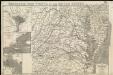
Maps of Maryland
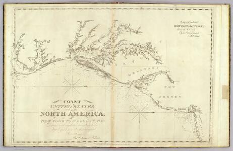
The coast of the United States from New York to St. Augustine (2nd sheet)
1 : 900000 Blunt, Edmund M. (Edmund March), 1770-1862
Map of Virginia, Maryland and Delaware / I. Mutlow sc. 6 James St. Covt. Gardn.
from Charts and maps
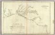
A map of that part of America where a degree of latitude was measured for the Royal Society / by Cha. Mason & Jere. Dixon.
from Charts and maps
Carte de la Virginie et du Maryland dressée sur la grande carte angloise de Mrs. Josué Fry et Pierre Jefferson, / par le Sr. Robert de Vaugondy, géographe; Groux.
from John H. Levine Collection Robert de Vaugondy; Mrs. Josué Fry et Pierre Jefferson,
A new and accurate map of the province of Virginia in North America.
from Virginia
Nova Virginiae Tabula [Karte], in: Gerardi Mercatoris et I. Hondii Newer Atlas, oder, Grosses Weltbuch, Bd. 2, S. 392.
1 Karte aus Atlas Mercator, Gerhard und Hondius, Jodocus Jansson, Jan
Nova Virginiae Tabula [Karte], in: Novus Atlas, das ist, Weltbeschreibung, Bd. 2, S. 325.
1 Karte aus Atlas Blaeu, Joan Blaeu, Willem Janszoon
The tourist's pocket map of the state of Virginia: exhibiting its internal improvements, roads, distances, &c. / by J.H. Young; engraved by E. Yeager & F. Dankworth.
from Virginia J. H. Young; E. Yeager; F. Dankworth,
The tourist's pocket map of the state of Virginia: exhibiting its internal improvements, roads, distances, &c. / by J.H. Young; engraved by E. Yeager & F. Dankworth.
from Virginia J. H. Young; E. Yeager; F. Dankworth,
The travellers pocket map of Virginia: with its canals, rail-roads & distances from place to place along the stage roads / by H.S. Tanner; engraved by W. Brose, Philadelphia, 1830.
from Virginia Henry S. Tanner; W. Brose,
Virginia
1 : 1300000 Smith, John [Merianische Erben]
One Hundred & Fifty Miles Around Richmond.
1 : 887040 Magnus, Charles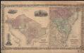
Colton's Georgetown and the city of Washington : the capital of the United States of America ; Colton's map showing part of Virginia, Maryland, Pennsylvania, New Jersey & New York
1 : 525000 Colton, J. H. Colton, J. H.
Nova Virginae Tabula [Karte], in: Theatrum orbis terrarum, sive, Atlas novus, Bd. 2, S. 327.
1 Karte aus Atlas Blaeu, Joan Blaeu, Willem Janszoon
Nova Virginiae Tabula [Karte], in: Le théâtre du monde, ou, Nouvel atlas contenant les chartes et descriptions de tous les païs de la terre, Bd. 2, S. 318.
1 Karte aus Atlas Blaeu, Willem Janszoon und Blaeu, Joan Blaeu, Willem Janszoon
Americae pars, nunc Virginia dicta : primum ab Anglis inuenta, sumtibus Dn. Walteri Raleigh, Equestris ordinis Viri, Anno Dni. MDLXXXV regni Vero Sereniss. nostrae Reginae Elisabethae XXVII, hujus vero Historia peculiari Libro descripta est, additis etia
from John H. Levine Collection
(Virginia, N. Carolina) Railroad Map of the United States.
1 : 506880 Rand McNally and Company

Strategic War Points of the United States no.3: the country round the Chesapeake and the Potomac to Washington
Strategic War points of the United States no.3: the country round the Chesapeake and the Potomac to Washington J. Wyld
A map of Virginia and Maryland
1 : 1150000 Speed, John Basset, Thomas
A map of Virginia : formed from actual surveys and the latest as well as the most accurate observations / by James Madison ; drawn by Wm. Davis ; with extensive additions and corrections to the year 1818.
from Charts and maps
Map Of The Seat Of War.
1 : 633600 Monk, Jacob
Map of part of Virginia, Maryland and Delaware from the best authorities
1 : 400000 Heyne, Charles E. & G.W. Blunt (Firm)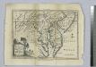
A map of Maryland with the Delaware counties and the southern part of New Jersey &c. / by T. Kitchin, geogr.
from Charts and maps Thomas Kitchin,
NOVA VIRGINIÆ TABVLA
DGrijp Sculpt [Amsterdam : Joan Blaeu]
A map of Virginia : formed from actual surveys, and the latest as well as most accurate observations / by James Madison, D.D., president of Wm. & Mary College. ; drawn by Wm. Davis ; engraved by Fred. Bossler, Richmd.
From Charts and maps
Virginia / discovered and described by Captayn John Smith, 1606.
from Charts and maps
A Chart of the Chesapeake And Delaware Bays
1 : 354816 Lucas, Fielding Jr.
Shell Highway Map of Delaware - Maryland, Virginia, W. Virginia. (western portion).
1 : 950400 Shell Oil Company