Maps of Carpathian Mountains

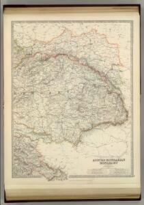
Austro-Hungarian Monarchy (eastern sheet).
1 : 1642000 Johnston, Alexander Keith
Austria E.
1 : 1642000 Johnston, Alexander Keith, 1804-1871
Russia in Europe / the map drawn & engraved by J. Rapkin ; the illustrations by A.H. Wray & engraved
1 : 15206400 1 Karte : Lithographie ; 29 x 22 cm Wray, A.H. J. & F. Tallis
Russia in Europe / drawn & engraved by J. Dower ...
1 : 15000000 1 Karte : Lithogr. (mehrfarb.) ; 25 x 20 cm Dower, John Orr & Smith
Beschreibung aller laender so etwan dem künigreich Poland underworffen seind gewesen, oder sunst mi
1 : 7500000 1 Karte : Holzschnitt ; 10 x 14 cm Münster, Sebastian [Henricpetri]
Russland. I. Das europaeische Russland, II. Das Königreich Polen, III. Die Republik Krakau
1 : 2500000 1 Karte : Lithographie ; 27 x 20 cm Schlieben, W.E.A. von [Georg Joachim Göschen]
Austria & Hungary (eastern sheet).
1 : 1642000 Johnston, W. & A.K.
Totius imperii Russici tabula generalis / ex optimis quibusvis Academiae Petropolit. mappis, quarum
1 : 7300000 1 Karte auf 3 Blatt : Kupferdruck ; 56 x 129 cm ; Einzelbl. 56 x 43 cm Büsching, Anton Friedrich [Verlag nicht ermittelbar]
Ungariae Loca Praecipua Recens [Karte], in: Theatrum orbis terrarum, S. 363.
1 Karte aus Atlas Ortelius, Abraham Vrients, Jan Baptista
Austro-Hungarian Monarchy (eastern sheet).
1 : 1642000 Johnston, Alexander Keith
Carte Generale l'Empire d'Autriche.
1 : 2700000 Vivien de St Martin, L.
Charte von Galizien und den Ungarischen Ländern
Ungarn, Galizien
Mappa Królestwa Polskiego / ułożona na zasadzie źródeł urzędowych prez M. Nipanicza
1 : 735000 1 Karte : Lithografie, koloriert ; 126 x 99 cm Nipanicz, Mikołaj [Verlag nicht ermittelbar]
A new [and] accurate map of Moscovy, or Russia in Europe, with its aquisitions / by Eman.l Bowen
1 : 2300000 1 Karte : Kupferdruck ; 31 x 21 cm Bowen, Emanuel [Verlag nicht ermittelbar]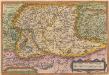
Ungariae Loca Praecipua Recens [Karte], in: Theatrum orbis terrarum, S. 268.
1 Karte aus Atlas Ortelius, Abraham
Karpaten-Land
Donau-Karpaten-Gebiet, Ungarn
Galizien, Ungarn, Slavonien, Kroatien, Siebenburgen, Dalmatien, Moldau, Wallachey.
1 : 10000000 Brudin, J. L.; Stieler, Adolf
OCTAVA EUROPE TABULA / [Kartograph: Nicolaus Germanus ; Stecher: Johannes von Armsheim]
1 : 5100000 1 Karte : Holzschnitt ; 40 x 57 cm Ptolemaeus, Claudius [Johann Reger?]
Hungary and Transylvania.
1 : 3800000 Lucas, Fielding Jr.
Ungarn mit seinen Nebenländern und Galizien
1 : 1600000 Dalmácie jižní (Chorvatsko) Kiepert, Heinrich Eulenstein, F. Geographisches Institut
Ungarn mit seinen Nebenländern und Galizien
1 : 1600000 Dalmácie jižní (Chorvatsko) Kiepert, Heinrich Blaschnek Verlag des Geographischen Institut
Ungarn mit seinen Nebenländern und Galizien
1 : 1600000 Dalmácie jižní (Chorvatsko) Kiepert, Heinrich Blaschnek Verlag des Geographisches Institut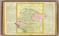
Hongrie.
1 : 2550000 Clouet, J. B. L. (Jean-Baptiste Louis), b. 1730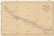
Heerstrasse von Constantinopel nach Nissa
Balkánský poloostrov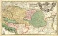
Eigentliche Vorstellung des so berühmten König. Reichs Ungarn neben Siebenbürgen, Moldau, Wallachey, Bosnien, und andern Ländern mehr bis an Constantinopel
1 : 1900000 Mollova mapová sbírka
Eigentlliche Forstellung des soberühmten könig. Reichs Ungarn neben Sibenbürgen, Moldau, Wallachen, Bosnien und anderr Ländern mehr bis an Constantinopel
1 : 2000000 Bosna
Galizien, Ungarn und Nebenländer
Neuer Handatlas über alle Theile der Erde Kiepert, Heinrich Verlag von Dietrich Reimer
Regnorum Hungariae Dalmatiae, Croatiae, Sclavoniae Bosniae et Serviae cum principatu Transylvaniae, maximaque parte Valachiae nova et exacta tabula
1 : 784000 Bosna Homann, Johann Baptist Müller, Johann Christoph á Io. Bapt. Homanno
Regni Hungariae
1 : 1400000 Mollova mapová sbírka Homann, Johann Baptist Homann, Johann Baptista - dědici