Maps of Carpathian Mountains

Galizien, Ungarn und Nebenländer
Neuer Handatlas über alle Theile der Erde Kiepert, Heinrich Verlag von Dietrich Reimer
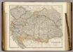
Ungarn mit seinen Nebenländern und Galizien
1 : 1600000 Dalmácie jižní (Chorvatsko) Kiepert, Heinrich Eulenstein, F. Geographisches Institut
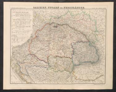
Ungarn mit seinen Nebenländern und Galizien
1 : 1600000 Dalmácie jižní (Chorvatsko) Kiepert, Heinrich Blaschnek Verlag des Geographischen Institut
Ungarn mit seinen Nebenländern und Galizien
1 : 1600000 Dalmácie jižní (Chorvatsko) Kiepert, Heinrich Blaschnek Verlag des Geographisches Institut
[Ungarn, Galizien, Schlavonien, Croatien und Siebenbürgen]
Neuester Schul-Atlas Walch, Johann im Verlag bei Joh. Walch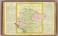
Hongrie.
1 : 2550000 Clouet, J. B. L. (Jean-Baptiste Louis), b. 1730
OCTAVA EUROPE TABULA / [Kartograph: Nicolaus Germanus ; Stecher: Johannes von Armsheim]
1 : 5100000 1 Karte : Holzschnitt ; 40 x 57 cm Ptolemaeus, Claudius [Johann Reger?]
Ungarn und Galizien
Allgemeiner Atlas [Walch, Johannes] im Verlag bei Johannes Walch
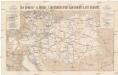
Carte ethnographique historique et stratégique des contrées Hongroises, Slaves, Moldo-Valaques et Allemandes de l'Empire Autrichien impliquées dans la guerre actuelle
Evropa jihovýchodní Bourgoing, Paul Charles Amable de imprimerie Gerdes
Ungarn mit Slavonien und Kroatien, Siebenbürgen die Militairgrenze und Galizien
Schul-Atlas in 36 Karten Völter, Daniel Verlag der J.M. Dannheimer'schen Buchhandlung
Etats Orientaux De L'Empereur a partir De La Baviere Et De La Boheme : pour l'Ouvrage intitulé: De la Monarchie Prussienne
Mentelle, Edme
Místopisná mapa Rakousko-Uherska
1 : 2000000 Rakousko-Uhersko Brunclík, Josef Jos. Švíkal
Místopisná mapa Rakousko-Uherska
1 : 2000000 Rakousko-Uhersko Brunclík, Josef Jos. Švíkal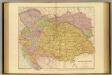
Austria-Hungary.
1 : 1774080 Stanford, Edward
Austrian Empire.
1 : 1774080 Arrowsmith, John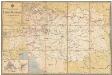
Übersichts-Karte der k. k. österr. Staatsbahnen
1 : 1550000 Evropa jihovýchodní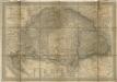
Magyar- Orság
Die Oesterr. u. Ungar. Eisenbahnen der Gegenwart u. der Zukunft
1 : 1850000 Evropa střední Artaria
Ungarn, Siebenburgen und Galizien
1 : 3580000 Halič (Polsko a Ukrajina) Stein, Carl
Etats orientaux de l'empereur a partir de la Baviere et de la Boheme
1 : 3170000 Evropa jihovýchodní Mentelle, Edme Tardieu, Pierre François

Karte von Ungarn und Siebenbürgen
1 : 2056000 Maďarsko Cotta von Cottendorf, Johann Georg Pobuda, W. von der J.G. Cotta'schen geographischen Anstalt
Volkerkarte v. Oesterreich-Ungarn.
1 : 4000000 Andree, Richard
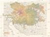
Karpaten-Land
Donau-Karpaten-Gebiet, Ungarn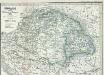
Ungarn seit der Schlacht bei Mohacs 1526
1 : 3700000 Ungarn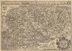
Hungariae Descriptio [Karte], in: Theatrum orbis terrarum, S. 360.
1 Karte aus Atlas Ortelius, Abraham Vrients, Jan Baptista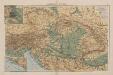
Österreich-Ungarn
1 : 4000000 Österreich-Ungarn