Maps of Carpathian Mountains

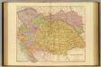
Ungarn und Galizien
Allgemeiner Atlas [Walch, Johannes] im Verlag bei Johannes Walch

Etats orientaux de l'empereur a partir de la Baviere et de la Boheme
1 : 3170000 Evropa jihovýchodní Mentelle, Edme Tardieu, Pierre François
Ethnog. Austria-Hungary
1 : 4000000 Andree, Richard; Times (London, England)
Etats Orientaux De L'Empereur a partir De La Baviere Et De La Boheme : pour l'Ouvrage intitulé: De la Monarchie Prussienne
Mentelle, Edme
Karpathenländer, Polen und Preussen
Ostmitteleuropa Skizzenbuch
General Charte von Ungarn
1 : 2390000 Bukovina (Rumunsko a Ukrajina) Güssefeld, Franz L. Rausch, Johann Lorenz Jakob bey den Homannischen Erben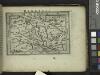
Hungaria.
from Abraham Ortelius his epitome of the theater of the worlde / nowe latlye ... renewed and augmented ... by Micheal Coignet, mathematitian of Antwarpe.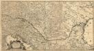
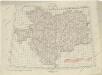
Totius Regni Hungariae
1 : 2200000 Mollova mapová sbírka Visscher, Nicolaes Jansz.
Místopisná mapa Rakousko-Uherska
1 : 2000000 Rakousko-Uhersko Brunclík, Josef Jos. Švíkal
Místopisná mapa Rakousko-Uherska
1 : 2000000 Rakousko-Uhersko Brunclík, Josef Jos. Švíkal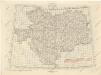
Übersichtblatt der Spezialkarte 1:75 000

Le nouveau systéme politique de l ́Europe centrale
1 : 2800000 Československo Barrere, H. H. Barrére
Osterreichisch. Ungarische Monarchie.
1 : 3700000 Vogel, C.
Neueste Postkarte der Saemtlichen K. k. teutsch und Ungarische Erblaender

Ungarn mit seinen Nebenländern und Galizien
1 : 1600000 Dalmácie jižní (Chorvatsko) Kiepert, Heinrich Eulenstein, F. Geographisches Institut
Ungarn mit seinen Nebenländern und Galizien
1 : 1600000 Dalmácie jižní (Chorvatsko) Kiepert, Heinrich Blaschnek Verlag des Geographischen Institut
Ungarn mit seinen Nebenländern und Galizien
1 : 1600000 Dalmácie jižní (Chorvatsko) Kiepert, Heinrich Blaschnek Verlag des Geographisches Institut
Galizien, Ungarn und Nebenländer
Neuer Handatlas über alle Theile der Erde Kiepert, Heinrich Verlag von Dietrich Reimer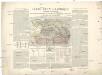
Carte ethnographique historique et stratégique des contrées Hongroises, Slaves, Moldo-Valaques et Allemandes de l'Empire Autrichien impliquées dans la guerre actuelle
Evropa jihovýchodní Bourgoing, Paul Charles Amable de imprimerie Gerdes
Artaria's Eisenbahn- u. Post-Communications-Karte v. Oesterreich-Ungarn
1 : 1745000 Rakousko-Uhersko Artaria
OCTAVA EUROPE TABULA / [Kartograph: Nicolaus Germanus ; Stecher: Johannes von Armsheim]
1 : 5100000 1 Karte : Holzschnitt ; 40 x 57 cm Ptolemaeus, Claudius [Johann Reger?]
Rakousko-Uhersko, mapa národopisná
1 : 2750000 Banát Machát, František J. Otto
Östereich-Ungarn
1 : 1500000 Rakousko-Uhersko Mittelbach's Verlag
Polsko, Československo, Maďarsko a Rumunsko

Kaisertum Österreich 1809 nach dem Frieden von Schönbrunn
Österreich Wien-Schönbrunn / Friede Kunz, Andreas ; Moeschl, Joachim Robert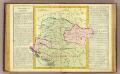
Hongrie.
1 : 2550000 Clouet, J. B. L. (Jean-Baptiste Louis), b. 1730
Übersichtblatt der Spezialkarte 1:75 000