Maps of Gabon

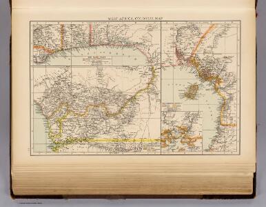
West Africa.
1 : 2500000 Andree, Richard; Times (London, England)
A chart of coast of BIAFRA from Foche Island to Corisco Island together with the Islands of FERNANDO POO and PRINCES
from The sea-atlas : containing an hydrographical description of most of the sea-coasts of the known parts of the world.
Kolonien (Schutzgebiete) des Deutschen Reichs
1 : 6000000 Afrika jihozápadní F.A. Brockhaus Geogr.-artist. Anstalt
Afrique équatoriale Francaise
1 : 5000000 Afrika střední Barralier, Emmanuel Emile Larose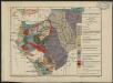
Carte géologique de l'Afrique équatoriale française. Planche sud
1 : 5000000 Loir, Erasme, géologue 18..-19.. Paris : Larose
Afrique equatoriale Française
1 : 2000000 Kongo (Brazzaville) Meunier, A. Courtier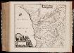
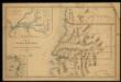
Regna Congo et Angola
1 : 3000000 Annotatie: Origineel is Blad 209 in atlas factice; Annotatie geografische gegevens: Schaalstok op kaart: 2 Milliaria Germanica Communia (=7,2 cm) [Amstelædami] : [Labore et Sumptibus Ioannis Blaev]
Carte du Cameroun
1 : 2000000 Kamerun
Localisatin of ethnic groups. Southern section. Sheet XI

Golfe du Guinee. Afrique 36.
1 : 1641836 Vandermaelen, Philippe, 1795-1869
Anzico. Afrique 38.
1 : 1641836 Vandermaelen, Philippe, 1795-1869
Colonie du Gabon. Afrique Equatoriale Française
1 : 1000000 Meunier, A., cartographe Paris : Ministère des colonies
Vorläufige übersicht von Zintgraff's Reise von Kamerun nach dem Benuë
1 : 3500000 Kamerun C.L. Keller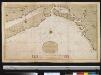
Een gedeelte van de kust van Gunea van Accara tot C. Formosa vertoonende de Bogt van Benin
Ghana Gerard van Keulen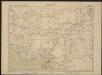
Carte de l'Afrique occidentale française. Forcados
1 : 2000000 France. Service géographique des colonies [Paris] : Service géographique des colonies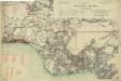
Map of the Gold Coast, Ashanti and Northern Territories
Map of the Gold Coast, Ashanti and Northern Territories, GSGS 2593. Great Britain. General Staff. Geographical Section. [London] : [GSGS, War Office]
Nigeria

Map of the south-western part of Cameroon (containing the Basel Mission area)
Mapa de la Guinea Española / formado y publicado por el Depósito de la Guerra
1 : 500000 1 Mapa, col. Finestra: Plano del Rio Muni y sus afluentes Depósito de la Guerra (Espaya)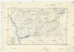
Croquis hypsométrique du Congo occidental
1 : 1000000 Kongo (Kinshasa) Delhaye, F. Sluys, M. E. Patesson
Karte des Handelsgebiets von West-Aequatoreal-Afrika
1 : 780000 L. Friedrichsen Hambourg : Friederichsen
Région des cours supérieurs de l'Ogôoué, de l'Alima et de la Licona (Carte provisoire)
1 : 1000000 Brazza, Pierre Savorgnan de 1852-1905 Paris : Société de géographie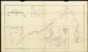
Route sketch of H. Ramsay's expedition in the southern Cameroon regions

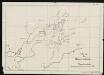
Stationen und Arbeitsgebiete der Basler Mission im Grasland v. Kamerun
Tischhauser, G.
Mapa del Muni : Guinea continental española
1 mapa. Publicat dins: Anuario general de España. Datat a partir de 1900 aproximadament. Pompido, M. Publicado por `Anuarios Bailly-Baillère y Riera reunidos ́. Barcelona (ed. A)
Karte des Kamerun-Gebiets
Sketch of the Bassa region.
Autenrieth
Karte des Gebiets zwischen Bali und Nyasoso, zum Reisebericht Br. Dorsch's
Dorsch, H.
Région du chemin de fer Congo-océan (esquisse topographique). Feuille 1 : Brazzaville-Kimbédi
1 : 250000 Lombard, Jean 1895-.... Paris : H. Barrère