Maps of Manhattan Community Board 9
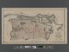
[Long Island City, Queens] Record of searches in relation to the legal status of avenues and streets in the 1st Ward of the Borough of Queens.
From Queens
Map of Newtown Creek and vicinity / prepared by the Department of Health of Brooklyn, N.Y., January 1896 ; W.W. Locke, sanitary engineer.
from Brooklyn
Map of Long Island City, Queens County, N. Y., showing farmlines, reduced from Commissioners new city map.
From Queens
Key
From Atlas 141. Vol. 5, 1903.
Upper West Side, Yorkville, Lenox Hill, Welfare Island. (cont.)
From District 8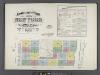
Insurance maps of the City of New York. Surveyed and published by Sanborn-Perris Map Co., Limited. 115 Broadway, 1892. Volume 6. / Key
From Atlas 117. Vol. 6, 1892.
Map of the Harlem River and Spuyten Duyvil Creek from Ward's Island to the Hudson River, showing project for a covered waterway 60 feet wide to be built on the west line of the Harlem River from the easterly side of Third Avenue to 165th street, New Y...
From Manhattan
Morrisania, Westchester Co. N.Y.
from County atlas of Westchester, New York. Published by J.B. Beers & Co., assisted by S.W. Wilson and others.
New York City from 50th street to 127th street showing Central Park, Bloomingdale village, Yorkville, and the southern part of Harlem.
From Manhattan
Outline and Index Map of Atlas of New York City.
from Atlas of the borough of Manhattan, city of New York.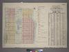
Outline & Index Map of Volume One, Atlas of New York City, Borough of Manhattan : 59th Street to 110th Street.
from Atlas of the city of New York, borough of Manhattan. From actual surveys and official plans / by George W. and Walter S. Bromley.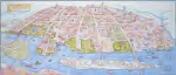
Map of the Astoria, Long Island City waterfront parks and environs: history, culture, ecology, parks / artwork, David Cain (map poster); George Colbert, Guenter Vollath (wayfinding map).
David Cain; George Colbert; Guenter Vollath,
Map and plan showing the street system in the 1st ward of the borough of Queens, formerly Long Island City.
From Queens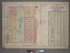
Outline and Index Map of Atlas of New York City, Borough of Manhattan. 59th St. to 110th Street. Street Index.
from Atlas of the city of New York, borough of Manhattan. From actual surveys and official plans / by George W. and Walter S. Bromley.
Map and plan showing the street system in the 1st ward of the borough of Queens, formerly Long Island City.
From Queens
Central Park
1 : 24000
Central Park
1 : 24000
Central Park
1 : 24000
Central Park
1 : 24000
Central Park
1 : 24000
Central Park
1 : 24000
Central Park
1 : 24000
Central Park
1 : 24000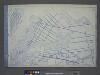
Use District Map Section No. 9
from Use district map / City of New York, Board of Estimate and Apportionment.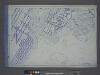
Use District Map Section No. 6
from Use district map / City of New York, Board of Estimate and Apportionment.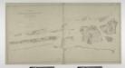
Blackwell's, Ward's and Randall's islands and adjacent shores of East and Harlem Rivers : from 51st St. New York to Lawrence's Pt. / U.S. Coast and Geodetic Survey, F.M. Thorn, superintendent ; surveyed by E. Hergesheimer, assistant, 1885.
from New York harbor
Topographical atlas of the city of New York, including the annexed territory showing original water courses and made land. / prepared under the direction of Egbert L. Viele.
From Topographical atlas of the city of New York, including the annexed territory showing original water courses and made land
Nostrands map of New York house numbers and subway guide. Ohman Map Co.
1 : 16000 Nostrand, George J.
Key
From Atlas 134. Vol. 2, 1915.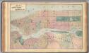
![[Long Island City, Queens] Record of searches in relation to the legal status of avenues and streets in the 1st Ward of the Borough of Queens.](https://images-1.georeferencer.com/images/iiif/532399797221/full/,300/0/native.jpg)

