Maps of Manhattan Community Board 9

Upper West Side, Yorkville, Lenox Hill, Welfare Island. (cont.)
From District 8
Map of the Harlem River and Spuyten Duyvil Creek from Ward's Island to the Hudson River, showing project for a covered waterway 60 feet wide to be built on the west line of the Harlem River from the easterly side of Third Avenue to 165th street, New Y...
From Manhattan
Morrisania, Westchester Co. N.Y.
from County atlas of Westchester, New York. Published by J.B. Beers & Co., assisted by S.W. Wilson and others.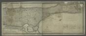
[Map of the city of New York and island of Manhattan as laid out by the commissioners appointed by the Legislature, April 3, 1807]
from Manhattan
Key
From Atlas 141. Vol. 5, 1903.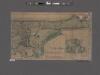
Topographical map of the city of New York, showing original water courses and made land ; prepared under direction of Egbert L. Viele, Topogr. Eng'r. Bound with his Topography and Hydrology of New York.
From Manhattan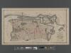
[Long Island City, Queens] Record of searches in relation to the legal status of avenues and streets in the 1st Ward of the Borough of Queens.
From Queens
Central Park
1 : 24000
Central Park
1 : 24000
Central Park
1 : 24000
Central Park
1 : 24000
Central Park
1 : 24000
Central Park
1 : 24000
Central Park
1 : 24000
Central Park
1 : 24000
Map of Newtown Creek and vicinity / prepared by the Department of Health of Brooklyn, N.Y., January 1896 ; W.W. Locke, sanitary engineer.
from Brooklyn
Outline and Index Map, Sections 9 and 10, Borough of the Bronx.
from Atlas and owners names, borough of the Bronx, sections 9 & 10 : from actual surveys and official plans / by George W. and Walter S. Bromley.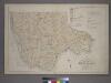
Outline and Index Map of the 23rd Ward, City of New York.
from Atlas of the city of New York : from official records, private plans & actual surveys / compiled under the supervision of E. Robinson & R. H. Pidgeon.
Map and plan showing the street system in the 1st ward of the borough of Queens, formerly Long Island City.
From Queens
Map of Long Island City, Queens County, N. Y., showing farmlines, reduced from Commissioners new city map.
From Queens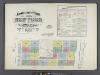
Insurance maps of the City of New York. Surveyed and published by Sanborn-Perris Map Co., Limited. 115 Broadway, 1892. Volume 6. / Key
From Atlas 117. Vol. 6, 1892.
Use District Map Section No. 6
from Use district map / City of New York, Board of Estimate and Apportionment.
Topographical atlas of the city of New York, including the annexed territory showing original water courses and made land. / prepared under the direction of Egbert L. Viele.
From Topographical atlas of the city of New York, including the annexed territory showing original water courses and made land
Use District Map Section No. 9
from Use district map / City of New York, Board of Estimate and Apportionment.
Front Cover
from Height district map / City of New York, Board of Estimate and Apportionment.
Jackson Heights, North Corona, East Elmhurst. (cont.)
From District 3
New York City from 50th street to 127th street showing Central Park, Bloomingdale village, Yorkville, and the southern part of Harlem.
From Manhattan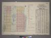
Outline & Index Map of Volume One, Atlas of New York City, Borough of Manhattan : 59th Street to 110th Street.
from Atlas of the city of New York, borough of Manhattan. From actual surveys and official plans / by George W. and Walter S. Bromley.
Key
From Atlas 134. Vol. 2, 1915.